Distance between La cienega and Colonia Luis Donaldo Colosio
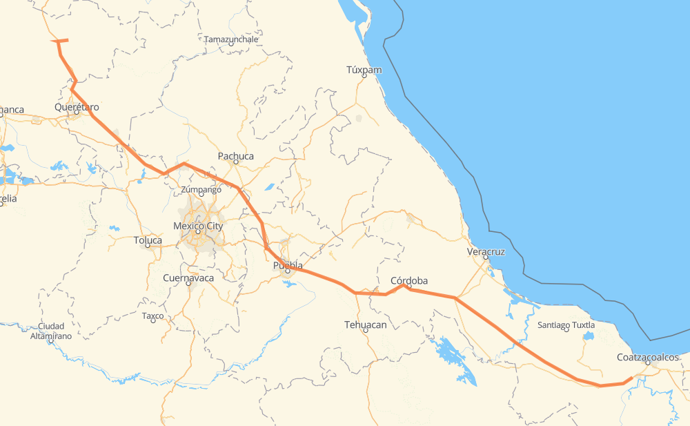
The distance from La cienega to Colonia Luis Donaldo Colosio is 862 kilometers by road including 848 kilometers on motorways. Road takes approximately 9 hours and 12 minutes and goes through San Juan del Rio, Orizaba, Parque Industrial Queretaro, Santa María Moyotzingo, San Miguel Xoxtla, San Francisco Ocotlán (Ocotlán) and Acatzingo de Hidalgo.
| Shortest distance by air | 717 km ✈️ |
| Car route length | 862 km 🚗 |
| Driving time | 9 h 12 min |
| Fuel amount | 68.9 L |
| Fuel cost | 135.1 CAD |
| Toll roads cost | 770 + ? MXN |
| Point | Distance | Time | Fuel | |
| La cienega | 0 km | 00 min | 0.0 L | |
|
MEX 110 MEX 57 72 km, 47 min
|
||||
| Parque Industrial Queretaro | 72 km | 47 min | 5.4 L | |
|
MEX 57 MEX 57D 72 km, 48 min
|
||||
| San Juan del Rio | 145 km | 1 h 36 min | 11.1 L | |
|
MEX 57 MEX M40D 244 km, 2 h 31 min
|
||||
| Santa María Moyotzingo | 389 km | 4 h 07 min | 30.9 L | |
|
MEX 150D 12 km, 07 min
|
||||
| San Miguel Xoxtla | 400 km | 4 h 15 min | 31.5 L | |
|
MEX 150D 8 km, 05 min
|
||||
| San Francisco Ocotlán (Ocotlán) | 408 km | 4 h 20 min | 32.6 L | |
|
MEX 150D 63 km, 40 min
|
||||
| Acatzingo de Hidalgo | 470 km | 5 h 01 min | 37.2 L | |
|
MEX 150D 89 km, 1 h 04 min
|
||||
| Orizaba | 560 km | 6 h 06 min | 44.4 L | |
|
MEX 150D MEX 145D 306 km, 3 h 06 min
|
||||
| Colonia Luis Donaldo Colosio | 865 km | 9 h 12 min | 68.1 L | |
Frequently Asked Questions
How many toll booths are there from La cienega to Colonia Luis Donaldo Colosio?
There are 12 toll booths between La cienega and Colonia Luis Donaldo Colosio: Fortín, Cuitláhuac, Cosamaloapan, Acayucan, Chichimequillas, Queretaro, Palmillas, San Martin Texmelucan, San Martín, Viaducto Elevado de Puebla, Amozoc and Esperanza 27.
How much does the toll booths cost from La cienega to Colonia Luis Donaldo Colosio?
Toll roads cost: Chichimequillas (51 MXN) + Palmillas (89 MXN) + Queretaro (?) + San Martin Texmelucan (?) + San Martín (42 MXN) + Viaducto Elevado de Puebla (?) + Amozoc (72 MXN) + Esperanza 27 (140 MXN) + Fortín (33 MXN) + Cuitláhuac (114 MXN) + Cosamaloapan (229 MXN) + Acayucan (?) = 770 + ? MXN
How much does it cost to drive from La cienega to Colonia Luis Donaldo Colosio?
Fuel cost: 135.1 CAD
This fuel cost is calculated as: (Route length 862 km / 100 km) * (Fuel consumption 8 L/100 km) * (Fuel price 1.96 CAD / L)
You can adjust fuel consumption and fuel price here.
Toll roads cost: 770 + ? MXN
How long is a car ride from La cienega to Colonia Luis Donaldo Colosio?
Driving time: 9 h 12 min
This time is calculated for driving at the maximum permitted speed, taking into account traffic rules restrictions.
- 87 km with a maximum speed 110 km/h = 47 min
- 542 km with a maximum speed 100 km/h = 5 h 25 min
- 20 km with a maximum speed 90 km/h = 13 min
- 198 km with a maximum speed 80 km/h = 2 h 28 min
- 5 km with a maximum speed 70 km/h = 4 min
- 8 km with a maximum speed 60 km/h = 7 min
- 5 km with a maximum speed 50 km/h = 6 min
The calculated driving time does not take into account intermediate stops and traffic jams.
How far is La cienega to Colonia Luis Donaldo Colosio by land?
The distance between La cienega and Colonia Luis Donaldo Colosio is 862 km by road including 848 km on motorways.
Precise satellite coordinates of highways were used for this calculation. The start and finish points are the centers of La cienega and Colonia Luis Donaldo Colosio respectively.
How far is La cienega to Colonia Luis Donaldo Colosio by plane?
The shortest distance (air line, as the crow flies) between La cienega and Colonia Luis Donaldo Colosio is 717 km.
This distance is calculated using the Haversine formula as a great-circle distance between two points on the surface of a sphere. The start and finish points are the centers of La cienega and Colonia Luis Donaldo Colosio respectively. Actual distance between airports may be different.
How many hours is La cienega from Colonia Luis Donaldo Colosio by plane?
Boeing 737 airliner needs 53 min to cover the distance of 717 km at a cruising speed of 800 km/h.
Small plane "Cessna 172" needs 3 h 15 min to flight this distance at average speed of 220 km/h.
This time is approximate and do not take into account takeoff and landing times, airport location and other real world factors.
How long is a helicopter ride from La cienega to Colonia Luis Donaldo Colosio?
Fast helicopter "Eurocopter AS350" or "Hughes OH-6 Cayuse" need 2 h 59 min to cover the distance of 717 km at a cruising speed of 240 km/h.
Popular "Robinson R44" needs 3 h 24 min to flight this distance at average speed of 210 km/h.
This time is approximate and do not take into account takeoff and landing times, aerodrome location and other real world factors.
What city is halfway between La cienega and Colonia Luis Donaldo Colosio?
The halfway point between La cienega and Colonia Luis Donaldo Colosio is San Jacinto. It is located about 4 km from the exact midpoint by road.
The distance from San Jacinto to La cienega is 435 km and driving will take about 4 h 40 min. The road between San Jacinto and Colonia Luis Donaldo Colosio has length 427 km and will take approximately 4 h 32 min.
The other cities located close to halfway point:
Where is La cienega in relation to Colonia Luis Donaldo Colosio?
La cienega is located 717 km north-west of Colonia Luis Donaldo Colosio.
La cienega has geographic coordinates: latitude 21.29989, longitude -100.48323.
Colonia Luis Donaldo Colosio has geographic coordinates: latitude 17.99417, longitude -94.61028.
Which highway goes from La cienega to Colonia Luis Donaldo Colosio?
The route from La cienega to Colonia Luis Donaldo Colosio follows MEX 150D, MEX 145D, MEX M40D, MEX 57.
Other minor sections pass along the road:
- MEX 57D: 95 km
- MEX 45: 40 km
- MEX 110: 13 km
- MEX 120: 12 km