Distance between La Carlota and Las Flores
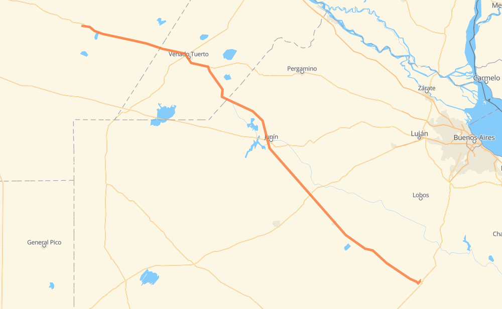
The distance from La Carlota to Las Flores is 529 kilometers by road. Road takes approximately 6 hours and 2 minutes and goes through Junín, Tiro Federal, General Arenales, Chacras del Bragado and 25 de Mayo.
| Shortest distance by air | 480 km ✈️ |
| Car route length | 529 km 🚗 |
| Driving time | 6 h 2 min |
| Fuel amount | 42.3 L |
| Fuel cost | 82.9 CAD |
| Point | Distance | Time | Fuel | |
| La Carlota | 0 km | 00 min | 0.0 L | |
|
RN8 134 km, 1 h 32 min
|
||||
| Tiro Federal | 134 km | 1 h 32 min | 10.6 L | |
|
RN8 34 km, 23 min
|
||||
| Santa Isabel | 168 km | 1 h 56 min | 12.6 L | |
|
RP94 12 km, 09 min
|
||||
| Villa Cañás | 180 km | 2 h 05 min | 14.3 L | |
|
RP65 73 km, 48 min
|
||||
| General Arenales | 253 km | 2 h 54 min | 18.2 L | |
|
RP65 30 km, 20 min
|
||||
| Junín | 283 km | 3 h 15 min | 22.4 L | |
|
RP65 41 km, 28 min
|
||||
| Chacras del Bragado | 324 km | 3 h 44 min | 23.3 L | |
|
RP46 78 km, 53 min
|
||||
| 25 de Mayo | 402 km | 4 h 37 min | 31.9 L | |
|
RP46 RP51 92 km, 1 h 02 min
|
||||
| El Trigo | 495 km | 5 h 39 min | 39.0 L | |
|
RP91 RP61 34 km, 23 min
|
||||
| Las Flores | 529 km | 6 h 02 min | 42.0 L | |
Hotels of Las Flores
Frequently Asked Questions
How much does it cost to drive from La Carlota to Las Flores?
Fuel cost: 82.9 CAD
This fuel cost is calculated as: (Route length 529 km / 100 km) * (Fuel consumption 8 L/100 km) * (Fuel price 1.96 CAD / L)
You can adjust fuel consumption and fuel price here.
How long is a car ride from La Carlota to Las Flores?
Driving time: 6 h 2 min
This time is calculated for driving at the maximum permitted speed, taking into account traffic rules restrictions.
- 448 km with a maximum speed 90 km/h = 4 h 58 min
- 67 km with a maximum speed 80 km/h = 50 min
- 13 km with a maximum speed 60 km/h = 12 min
The calculated driving time does not take into account intermediate stops and traffic jams.
How far is La Carlota to Las Flores by land?
The distance between La Carlota and Las Flores is 529 km by road.
Precise satellite coordinates of highways were used for this calculation. The start and finish points are the centers of La Carlota and Las Flores respectively.
How far is La Carlota to Las Flores by plane?
The shortest distance (air line, as the crow flies) between La Carlota and Las Flores is 480 km.
This distance is calculated using the Haversine formula as a great-circle distance between two points on the surface of a sphere. The start and finish points are the centers of La Carlota and Las Flores respectively. Actual distance between airports may be different.
How many hours is La Carlota from Las Flores by plane?
Boeing 737 airliner needs 36 min to cover the distance of 480 km at a cruising speed of 800 km/h.
Small plane "Cessna 172" needs 2 h 10 min to flight this distance at average speed of 220 km/h.
This time is approximate and do not take into account takeoff and landing times, airport location and other real world factors.
How long is a helicopter ride from La Carlota to Las Flores?
Fast helicopter "Eurocopter AS350" or "Hughes OH-6 Cayuse" need 2 h to cover the distance of 480 km at a cruising speed of 240 km/h.
Popular "Robinson R44" needs 2 h 17 min to flight this distance at average speed of 210 km/h.
This time is approximate and do not take into account takeoff and landing times, aerodrome location and other real world factors.
What city is halfway between La Carlota and Las Flores?
The halfway point between La Carlota and Las Flores is General Arenales. It is located about 11 km from the exact midpoint by road.
The distance from General Arenales to La Carlota is 253 km and driving will take about 2 h 54 min. The road between General Arenales and Las Flores has length 276 km and will take approximately 3 h 8 min.
The other cities located close to halfway point:
Where is La Carlota in relation to Las Flores?
La Carlota is located 480 km north-west of Las Flores.
La Carlota has geographic coordinates: latitude -33.41794, longitude -63.2935.
Las Flores has geographic coordinates: latitude -36.01497, longitude -59.09998.
Which highway goes from La Carlota to Las Flores?
The route from La Carlota to Las Flores follows RN8, RP46.
Other minor sections pass along the road:
- RP65: 82 km
- RP91: 52 km
- RP94: 40 km
- RP51: 39 km
- RP61: 22 km
- RP10-S: 3 km
- RN7: 3 km