Distance between L'Anse-au-Clair NL and Labrador City NL
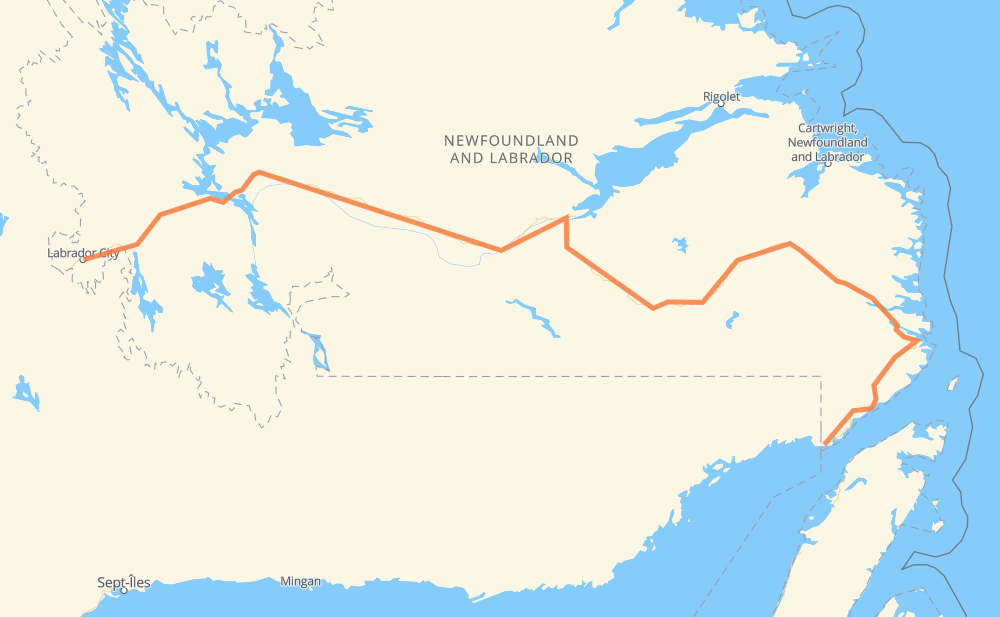
The distance from L'Anse-au-Clair to Labrador City is 1,121 kilometers by road. Road takes approximately 13 hours and goes through Lodge Bay, Mary’s Harbour, Port Hope Simpson, Churchill Falls and Wabush.
| Shortest distance by air | 692 km ✈️ |
| Car route length | 1,121 km 🚗 |
| Driving time | 13 h |
| Fuel amount | 89.7 L |
| Fuel cost | 176.6 CAD |
| Point | Distance | Time | Fuel | |
| L'Anse-au-Clair | 0 km | 00 min | 0.0 L | |
|
510 9 km, 06 min
|
||||
| Forteau | 9 km | 06 min | 0.4 L | |
|
510 24 km, 18 min
|
||||
| L'Anse au Loup | 33 km | 24 min | 1.0 L | |
|
510 75 km, 56 min
|
||||
| Lodge Bay | 108 km | 1 h 20 min | 4.3 L | |
|
510 96 km, 1 h 10 min
|
||||
| Port Hope Simpson | 205 km | 2 h 31 min | 14.9 L | |
|
510 656 km, 7 h 21 min
|
||||
| Churchill Falls | 861 km | 9 h 53 min | 65.8 L | |
|
500 228 km, 2 h 42 min
|
||||
| Wabush | 1,089 km | 12 h 35 min | 84.8 L | |
|
500 32 km, 25 min
|
||||
| Labrador City | 1,121 km | 13 h 00 min | 89.3 L | |
Hotels of Labrador City
Frequently Asked Questions
How much does it cost to drive from L'Anse-au-Clair to Labrador City?
Fuel cost: 176.6 CAD
This fuel cost is calculated as: (Route length 1,121 km / 100 km) * (Fuel consumption 8 L/100 km) * (Fuel price 1.97 CAD / L)
You can adjust fuel consumption and fuel price here.
How long is a car ride from L'Anse-au-Clair to Labrador City?
Driving time: 13 h
This time is calculated for driving at the maximum permitted speed, taking into account traffic rules restrictions.
- 733 km with a maximum speed 90 km/h = 8 h 8 min
- 387 km with a maximum speed 80 km/h = 4 h 50 min
The calculated driving time does not take into account intermediate stops and traffic jams.
How far is L'Anse-au-Clair to Labrador City by land?
The distance between L'Anse-au-Clair and Labrador City is 1,121 km by road.
Precise satellite coordinates of highways were used for this calculation. The start and finish points are the centers of L'Anse-au-Clair and Labrador City respectively.
How far is L'Anse-au-Clair to Labrador City by plane?
The shortest distance (air line, as the crow flies) between L'Anse-au-Clair and Labrador City is 692 km.
This distance is calculated using the Haversine formula as a great-circle distance between two points on the surface of a sphere. The start and finish points are the centers of L'Anse-au-Clair and Labrador City respectively. Actual distance between airports may be different.
How many hours is L'Anse-au-Clair from Labrador City by plane?
Boeing 737 airliner needs 51 min to cover the distance of 692 km at a cruising speed of 800 km/h.
Small plane "Cessna 172" needs 3 h 8 min to flight this distance at average speed of 220 km/h.
This time is approximate and do not take into account takeoff and landing times, airport location and other real world factors.
How long is a helicopter ride from L'Anse-au-Clair to Labrador City?
Fast helicopter "Eurocopter AS350" or "Hughes OH-6 Cayuse" need 2 h 53 min to cover the distance of 692 km at a cruising speed of 240 km/h.
Popular "Robinson R44" needs 3 h 17 min to flight this distance at average speed of 210 km/h.
This time is approximate and do not take into account takeoff and landing times, aerodrome location and other real world factors.
What city is halfway between L'Anse-au-Clair and Labrador City?
The halfway point between L'Anse-au-Clair and Labrador City is Churchill Falls. It is located about 300 km from the exact midpoint by road.
The distance from Churchill Falls to L'Anse-au-Clair is 861 km and driving will take about 9 h 53 min. The road between Churchill Falls and Labrador City has length 260 km and will take approximately 3 h 7 min.
Where is L'Anse-au-Clair in relation to Labrador City?
L'Anse-au-Clair is located 692 km east of Labrador City.
L'Anse-au-Clair has geographic coordinates: latitude 51.43417, longitude -57.0642.
Labrador City has geographic coordinates: latitude 52.94229, longitude -66.91774.
Which highway goes from L'Anse-au-Clair to Labrador City?
The route from L'Anse-au-Clair to Labrador City follows 510, 500.