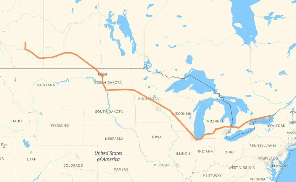
Distance between Kingston ON and Newcastle AB
The distance from Kingston to Newcastle is 3,660 kilometers by road including 2,426 kilometers on motorways. Road takes approximately 37 hours and 7 minutes and goes through Belleville, Oshawa, Ajax, Toronto, Mississauga, Kitchener and Woodstock.
| Shortest distance by air | 2,791 km ✈️ |
| Car route length | 3,660 km 🚗 |
| Driving time | 37 h 7 min |
| Fuel amount | 292.8 L |
| Fuel cost | 565.2 CAD |
| Point | Distance | Time | Fuel | |
| Kingston | 0 km | 00 min | 0.0 L | |
|
401 78 km, 47 min
|
||||
| Belleville | 78 km | 47 min | 5.3 L | |
|
401 126 km, 1 h 15 min
|
||||
| Oshawa | 204 km | 2 h 03 min | 16.0 L | |
|
401 15 km, 08 min
|
||||
| Ajax | 218 km | 2 h 12 min | 17.2 L | |
|
401 32 km, 19 min
|
||||
| Toronto | 250 km | 2 h 31 min | 18.3 L | |
|
401 31 km, 18 min
|
||||
| Mississauga | 281 km | 2 h 49 min | 21.7 L | |
|
401 66 km, 39 min
|
||||
| Kitchener | 347 km | 3 h 29 min | 27.5 L | |
|
401 42 km, 25 min
|
||||
| Woodstock | 389 km | 3 h 54 min | 30.7 L | |
|
401 402 140 km, 1 h 19 min
|
||||
| Sarnia | 529 km | 5 h 14 min | 41.6 L | |
|
402 I 69 122 km, 1 h 12 min
|
||||
| Flint | 651 km | 6 h 26 min | 51.7 L | |
|
I 69 99 km, 53 min
|
||||
| Lansing | 750 km | 7 h 20 min | 59.8 L | |
|
I 69 102 km, 55 min
|
||||
| Kalamazoo | 851 km | 8 h 16 min | 67.9 L | |
|
I 94 I 90 409 km, 3 h 53 min
|
||||
| Janesville | 1,261 km | 12 h 09 min | 100.6 L | |
|
I 39 56 km, 30 min
|
||||
| Madison | 1,317 km | 12 h 40 min | 104.6 L | |
|
I 39 I 94 282 km, 2 h 34 min
|
||||
| Eau Claire | 1,599 km | 15 h 15 min | 127.0 L | |
|
I 94 519 km, 4 h 48 min
|
||||
| Fargo | 2,119 km | 20 h 03 min | 169.3 L | |
|
I 94 7 km, 04 min
|
||||
| West Fargo | 2,126 km | 20 h 08 min | 169.7 L | |
|
I 94 294 km, 2 h 41 min
|
||||
| Bismarck | 2,420 km | 22 h 49 min | 193.0 L | |
|
US 83 158 km, 1 h 54 min
|
||||
| Minot | 2,579 km | 24 h 43 min | 204.5 L | |
|
US 83 US 52 210 km, 2 h 32 min
|
||||
| Estevan | 2,789 km | 27 h 15 min | 222.7 L | |
|
39A 39 87 km, 1 h 01 min
|
||||
| Weyburn | 2,876 km | 28 h 17 min | 224.9 L | |
|
39 178 km, 2 h 01 min
|
||||
| Moose Jaw | 3,055 km | 30 h 18 min | 241.4 L | |
|
1 139 km, 1 h 32 min
|
||||
| Swift Current | 3,194 km | 31 h 50 min | 255.0 L | |
|
1 221 km, 2 h 27 min
|
||||
| Medicine Hat | 3,415 km | 34 h 18 min | 272.7 L | |
|
1 106 km, 1 h 10 min
|
||||
| Brooks | 3,521 km | 35 h 29 min | 281.2 L | |
|
1 56 142 km, 1 h 38 min
|
||||
| Newcastle | 3,663 km | 37 h 08 min | 292.9 L | |
Frequently Asked Questions
How much does it cost to drive from Kingston to Newcastle?
Fuel cost: 565.2 CAD
This fuel cost is calculated as: (Route length 3,660 km / 100 km) * (Fuel consumption 8 L/100 km) * (Fuel price 1.93 CAD / L)
You can adjust fuel consumption and fuel price here.
How long is a car ride from Kingston to Newcastle?
Driving time: 37 h 7 min
This time is calculated for driving at the maximum permitted speed, taking into account traffic rules restrictions.
- 1,750 km with a maximum speed 110 km/h = 15 h 54 min
- 32 km with a maximum speed 105 km/h = 18 min
- 529 km with a maximum speed 100 km/h = 5 h 17 min
- 50 km with a maximum speed 97 km/h = 31 min
- 823 km with a maximum speed 90 km/h = 9 h 8 min
- 29 km with a maximum speed 89 km/h = 19 min
- 439 km with a maximum speed 80 km/h = 5 h 29 min
- 3 km with a maximum speed 72 km/h = 2 min
- 2 km with a maximum speed 70 km/h = 1 min
- 2 km with a maximum speed 50 km/h = 2 min
The calculated driving time does not take into account intermediate stops and traffic jams.
How far is Kingston to Newcastle by land?
The distance between Kingston and Newcastle is 3,660 km by road including 2,426 km on motorways.
Precise satellite coordinates of highways were used for this calculation. The start and finish points are the centers of Kingston and Newcastle respectively.
How far is Kingston to Newcastle by plane?
The shortest distance (air line, as the crow flies) between Kingston and Newcastle is 2,791 km.
This distance is calculated using the Haversine formula as a great-circle distance between two points on the surface of a sphere. The start and finish points are the centers of Kingston and Newcastle respectively. Actual distance between airports may be different.
How many hours is Kingston from Newcastle by plane?
Boeing 737 airliner needs 3 h 29 min to cover the distance of 2,791 km at a cruising speed of 800 km/h.
Small plane "Cessna 172" needs 12 h 41 min to flight this distance at average speed of 220 km/h.
This time is approximate and do not take into account takeoff and landing times, airport location and other real world factors.
How long is a helicopter ride from Kingston to Newcastle?
Fast helicopter "Eurocopter AS350" or "Hughes OH-6 Cayuse" need 11 h 37 min to cover the distance of 2,791 km at a cruising speed of 240 km/h.
Popular "Robinson R44" needs 13 h 17 min to flight this distance at average speed of 210 km/h.
This time is approximate and do not take into account takeoff and landing times, aerodrome location and other real world factors.
What city is halfway between Kingston and Newcastle?
The halfway point between Kingston and Newcastle is Monticello. It is located about 11 km from the exact midpoint by road.
The distance from Monticello to Kingston is 1,820 km and driving will take about 17 h 18 min. The road between Monticello and Newcastle has length 1,841 km and will take approximately 19 h 48 min.
The other cities located close to halfway point:
Where is Kingston in relation to Newcastle?
Kingston is located 2,791 km east of Newcastle.
Kingston has geographic coordinates: latitude 44.23069, longitude -76.48132.
Newcastle has geographic coordinates: latitude 51.46382, longitude -112.73823.
Which highway goes from Kingston to Newcastle?
The route from Kingston to Newcastle follows I 94, 1, 401, I 90, US 52, I 69, 39, US 83, I 39, 402.
Other minor sections pass along the road:
- 56: 74 km
- ND 5: 47 km
- I 694: 46 km
- US 51: 30 km
- 19: 26 km
- US 41: 22 km
- US 2: 20 km
- US 59: 17 km
- 41: 16 km
- ND 3: 12 km
- 39A: 11 km
- 18: 11 km
- US 12: 9 km
- 10: 8 km
- ND 1: 8 km
- I 96: 8 km
- MN 95: 7 km
- ND 200: 6 km
- ND 1804: 5 km
- MN 210: 5 km
- US 31: 5 km
- US 10: 5 km
- WI 35: 4 km
- 6: 4 km
- US 83 Bypass: 4 km
- US 20: 3 km
- WI 11: 3 km
- US 52 Truck: 3 km
- US 281 Truck: 2 km
- 575: 2 km