Distance between Kayadibi and Sancaktepe
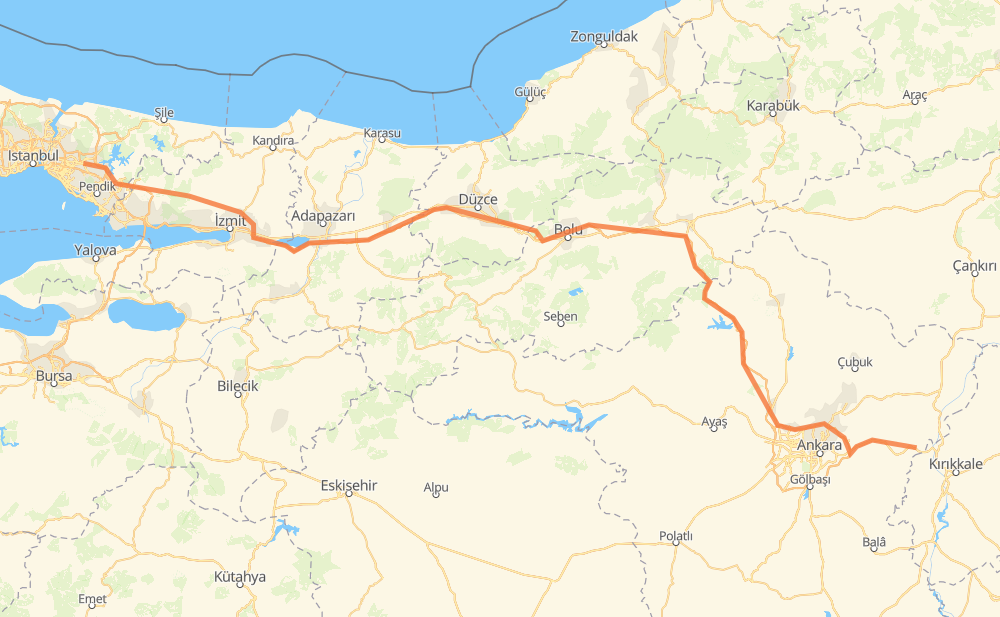
The distance from Kayadibi to Sancaktepe is 473 kilometers by road including 426 kilometers on motorways. Road takes approximately 5 hours and 1 minute and goes through Elmadağ, Bahçelievler Mah., Kızılca Mah., Baraj Mah., Kuzey Yıldızı Mah., Sarayköy Mah. and Osmanfakı.
| Shortest distance by air | 368 km ✈️ |
| Car route length | 473 km 🚗 |
| Driving time | 5 h 1 min |
| Fuel amount | 37.8 L |
| Fuel cost | 74.2 CAD |
| Point | Distance | Time | Fuel | |
| Kayadibi | 0 km | 00 min | 0.0 L | |
|
D200 16 km, 11 min
|
||||
| Elmadağ | 16 km | 11 min | 0.6 L | |
|
D200 24 km, 17 min
|
||||
| Kızılca Mah. | 39 km | 28 min | 3.0 L | |
|
O-20 15 km, 09 min
|
||||
| Baraj Mah. | 55 km | 38 min | 4.0 L | |
|
O-20 8 km, 05 min
|
||||
| Kuzey Yıldızı Mah. | 63 km | 44 min | 4.8 L | |
|
O-20 17 km, 10 min
|
||||
| Sarayköy Mah. | 80 km | 55 min | 6.1 L | |
|
D750 O-4 76 km, 52 min
|
||||
| Osmanfakı | 155 km | 1 h 47 min | 11.7 L | |
|
O-4 16 km, 11 min
|
||||
| Beylik | 171 km | 1 h 59 min | 13.5 L | |
|
O-4 97 km, 1 h 05 min
|
||||
| Kaynaşlı | 269 km | 3 h 05 min | 21.2 L | |
|
O-4 35 km, 19 min
|
||||
| Gümüşova | 303 km | 3 h 24 min | 23.7 L | |
|
O-4 170 km, 1 h 36 min
|
||||
| 41.01048, 29.21233 | 473 km | 5 h 00 min | 37.8 L | |
Frequently Asked Questions
How much does it cost to drive from Kayadibi to Sancaktepe?
Fuel cost: 74.2 CAD
This fuel cost is calculated as: (Route length 473 km / 100 km) * (Fuel consumption 8 L/100 km) * (Fuel price 1.96 CAD / L)
You can adjust fuel consumption and fuel price here.
How long is a car ride from Kayadibi to Sancaktepe?
Driving time: 5 h 1 min
This time is calculated for driving at the maximum permitted speed, taking into account traffic rules restrictions.
- 173 km with a maximum speed 110 km/h = 1 h 34 min
- 125 km with a maximum speed 100 km/h = 1 h 14 min
- 4 km with a maximum speed 90 km/h = 2 min
- 167 km with a maximum speed 80 km/h = 2 h 5 min
- 4 km with a maximum speed 70 km/h = 3 min
The calculated driving time does not take into account intermediate stops and traffic jams.
How far is Kayadibi to Sancaktepe by land?
The distance between Kayadibi and Sancaktepe is 473 km by road including 426 km on motorways.
Precise satellite coordinates of highways were used for this calculation. The start and finish points are the centers of Kayadibi and Sancaktepe respectively.
How far is Kayadibi to Sancaktepe by plane?
The shortest distance (air line, as the crow flies) between Kayadibi and Sancaktepe is 368 km.
This distance is calculated using the Haversine formula as a great-circle distance between two points on the surface of a sphere. The start and finish points are the centers of Kayadibi and Sancaktepe respectively. Actual distance between airports may be different.
How many hours is Kayadibi from Sancaktepe by plane?
Boeing 737 airliner needs 27 min to cover the distance of 368 km at a cruising speed of 800 km/h.
Small plane "Cessna 172" needs 1 h 40 min to flight this distance at average speed of 220 km/h.
This time is approximate and do not take into account takeoff and landing times, airport location and other real world factors.
How long is a helicopter ride from Kayadibi to Sancaktepe?
Fast helicopter "Eurocopter AS350" or "Hughes OH-6 Cayuse" need 1 h 32 min to cover the distance of 368 km at a cruising speed of 240 km/h.
Popular "Robinson R44" needs 1 h 45 min to flight this distance at average speed of 210 km/h.
This time is approximate and do not take into account takeoff and landing times, aerodrome location and other real world factors.
What city is halfway between Kayadibi and Sancaktepe?
The halfway point between Kayadibi and Sancaktepe is Yumrukaya. It is located about 11 km from the exact midpoint by road.
The distance from Yumrukaya to Kayadibi is 247 km and driving will take about 2 h 51 min. The road between Yumrukaya and Sancaktepe has length 226 km and will take approximately 2 h 9 min.
The other cities located close to halfway point:
Where is Kayadibi in relation to Sancaktepe?
Kayadibi is located 368 km east of Sancaktepe.
Kayadibi has geographic coordinates: latitude 39.94075, longitude 33.33388.
Sancaktepe has geographic coordinates: latitude 41.01048, longitude 29.21233.
Which highway goes from Kayadibi to Sancaktepe?
The route from Kayadibi to Sancaktepe follows O-4.
Other minor sections pass along the road:
- O-7: 60 km
- O-20: 38 km
- D200: 34 km
- D750: 6 km
- Kuzey Marmara Otoyolu: 5 km