Distance between Juventino Rosas and San Roberto
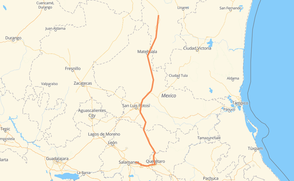
The distance from Juventino Rosas to San Roberto is 582 kilometers by road including 557 kilometers on motorways. Road takes approximately 6 hours and 7 minutes and goes through Celaya, Querétaro, Apaseo el Grande, Santa Rosa Jauregui, Parque Industrial Queretaro, Santa María del Río and Delegación de La Pila.
| Shortest distance by air | 458 km ✈️ |
| Car route length | 582 km 🚗 |
| Driving time | 6 h 7 min |
| Fuel amount | 46.6 L |
| Fuel cost | 91.2 CAD |
| Toll roads cost | 152 + ? MXN |
| Point | Distance | Time | Fuel | |
| Juventino Rosas | 0 km | 00 min | 0.0 L | |
|
MEX 51 24 km, 17 min
|
||||
| Celaya | 24 km | 17 min | 1.7 L | |
|
MEX 45D 13 km, 07 min
|
||||
| Apaseo el Grande | 36 km | 25 min | 2.7 L | |
|
MEX 45D 9 km, 05 min
|
||||
| El Nacimiento | 46 km | 30 min | 3.6 L | |
|
MEX 45D 24 km, 14 min
|
||||
| Querétaro | 70 km | 44 min | 4.9 L | |
|
MEX 57 16 km, 10 min
|
||||
| Santa Rosa Jauregui | 86 km | 55 min | 6.6 L | |
|
MEX 57 11 km, 07 min
|
||||
| Parque Industrial Queretaro | 97 km | 1 h 03 min | 7.5 L | |
|
MEX 57 166 km, 1 h 43 min
|
||||
| Delegación de La Pila | 263 km | 2 h 46 min | 20.0 L | |
|
MEX 57D MEX 57 246 km, 2 h 36 min
|
||||
| San Cayetano de Vacas | 508 km | 5 h 22 min | 38.3 L | |
|
MEX 57 74 km, 44 min
|
||||
| San Roberto | 582 km | 6 h 07 min | 44.6 L | |
Frequently Asked Questions
How many toll booths are there from Juventino Rosas to San Roberto?
There are 3 toll booths between Juventino Rosas and San Roberto: Matehuala Omega, Libramiento Oriente De SLP and Querétaro 6.
How much does the toll booths cost from Juventino Rosas to San Roberto?
Toll roads cost: Querétaro 6 (82 MXN) + Libramiento Oriente De SLP (70 MXN) + Matehuala Omega (?) = 152 + ? MXN
How much does it cost to drive from Juventino Rosas to San Roberto?
Fuel cost: 91.2 CAD
This fuel cost is calculated as: (Route length 582 km / 100 km) * (Fuel consumption 8 L/100 km) * (Fuel price 1.96 CAD / L)
You can adjust fuel consumption and fuel price here.
Toll roads cost: 152 + ? MXN
How long is a car ride from Juventino Rosas to San Roberto?
Driving time: 6 h 7 min
This time is calculated for driving at the maximum permitted speed, taking into account traffic rules restrictions.
- 95 km with a maximum speed 110 km/h = 51 min
- 252 km with a maximum speed 100 km/h = 2 h 31 min
- 175 km with a maximum speed 90 km/h = 1 h 56 min
- 55 km with a maximum speed 80 km/h = 41 min
- 2 km with a maximum speed 60 km/h = 1 min
- 2 km with a maximum speed 50 km/h = 1 min
The calculated driving time does not take into account intermediate stops and traffic jams.
How far is Juventino Rosas to San Roberto by land?
The distance between Juventino Rosas and San Roberto is 582 km by road including 557 km on motorways.
Precise satellite coordinates of highways were used for this calculation. The start and finish points are the centers of Juventino Rosas and San Roberto respectively.
How far is Juventino Rosas to San Roberto by plane?
The shortest distance (air line, as the crow flies) between Juventino Rosas and San Roberto is 458 km.
This distance is calculated using the Haversine formula as a great-circle distance between two points on the surface of a sphere. The start and finish points are the centers of Juventino Rosas and San Roberto respectively. Actual distance between airports may be different.
How many hours is Juventino Rosas from San Roberto by plane?
Boeing 737 airliner needs 34 min to cover the distance of 458 km at a cruising speed of 800 km/h.
Small plane "Cessna 172" needs 2 h 4 min to flight this distance at average speed of 220 km/h.
This time is approximate and do not take into account takeoff and landing times, airport location and other real world factors.
How long is a helicopter ride from Juventino Rosas to San Roberto?
Fast helicopter "Eurocopter AS350" or "Hughes OH-6 Cayuse" need 1 h 54 min to cover the distance of 458 km at a cruising speed of 240 km/h.
Popular "Robinson R44" needs 2 h 10 min to flight this distance at average speed of 210 km/h.
This time is approximate and do not take into account takeoff and landing times, aerodrome location and other real world factors.
What city is halfway between Juventino Rosas and San Roberto?
The halfway point between Juventino Rosas and San Roberto is Delegación de La Pila. It is located about 28 km from the exact midpoint by road.
The distance from Delegación de La Pila to Juventino Rosas is 263 km and driving will take about 2 h 46 min. The road between Delegación de La Pila and San Roberto has length 319 km and will take approximately 3 h 20 min.
The other cities located close to halfway point:
Where is Juventino Rosas in relation to San Roberto?
Juventino Rosas is located 458 km south of San Roberto.
Juventino Rosas has geographic coordinates: latitude 20.64354, longitude -100.99516.
San Roberto has geographic coordinates: latitude 24.71056, longitude -100.30373.
Which highway goes from Juventino Rosas to San Roberto?
The route from Juventino Rosas to San Roberto follows MEX 57.
Other minor sections pass along the road:
- MEX 80: 81 km
- MEX 57D: 47 km
- MEX 45D: 43 km
- QRO 10: 5 km
- QRO 10: 3 km
- MEX 51: 2 km