Distance between Jesús María and Mayo Fuerte
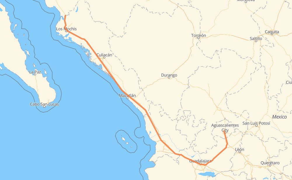
The distance from Jesús María to Mayo Fuerte is 1,177 kilometers by road including 1,113 kilometers on motorways. Road takes approximately 12 hours and 27 minutes and goes through Aguascalientes, Tonalá, Tepic, Dimas (Estación Dimas), Gabriel Leyva Solano and Los Mochis.
| Shortest distance by air | 839 km ✈️ |
| Car route length | 1,177 km 🚗 |
| Driving time | 12 h 27 min |
| Fuel amount | 94.2 L |
| Fuel cost | 184.5 CAD |
| Toll roads cost | 2,001 + ? MXN |
| Point | Distance | Time | Fuel | |
| Jesús María | 0 km | 00 min | 0.0 L | |
|
11 km, 08 min
|
||||
| Aguascalientes | 11 km | 08 min | 0.4 L | |
|
MEX 45 MEX 70 42 km, 27 min
|
||||
| Encarnación de Díaz | 53 km | 36 min | 4.0 L | |
|
MEX 45D MEX 80D 76 km, 44 min
|
||||
| Valle de Guadalupe | 129 km | 1 h 20 min | 10.0 L | |
|
MEX 80D 84 km, 50 min
|
||||
| Tonalá | 213 km | 2 h 10 min | 16.4 L | |
|
MEX 15D 222 km, 2 h 17 min
|
||||
| Tepic | 435 km | 4 h 27 min | 34.2 L | |
|
MEX 15D 333 km, 3 h 22 min
|
||||
| Dimas (Estación Dimas) | 768 km | 7 h 49 min | 60.4 L | |
|
MEX 15D 289 km, 3 h 10 min
|
||||
| Gabriel Leyva Solano | 1,057 km | 10 h 59 min | 83.7 L | |
|
MEX 15D 44 km, 31 min
|
||||
| Los Mochis | 1,101 km | 11 h 31 min | 87.9 L | |
|
MEX 15D 76 km, 56 min
|
||||
| Agiabampo Dos | 1,177 km | 12 h 27 min | 94.1 L | |
Frequently Asked Questions
How many toll booths are there from Jesús María to Mayo Fuerte?
There are 18 toll booths between Jesús María and Mayo Fuerte: San Miguel, Sinaloa, Las Brisas, San Pedro km 197+100, Costa Rica, Marmol, El Rosario, Acaponeta, Ruiz, Trapichillo, Santa Maria del Oro, Encarnacion De Diaz, Jalostotitlan, Tepatitlan, Plan de Barrancas, La Joya, Arenal and El Pisal.
How much does the toll booths cost from Jesús María to Mayo Fuerte?
Toll roads cost: Encarnacion De Diaz (150 MXN) + Jalostotitlan (177 MXN) + Tepatitlan (214 MXN) + La Joya (?) + Arenal (131 MXN) + Plan de Barrancas (195 MXN) + Santa Maria del Oro (115 MXN) + Trapichillo (80 MXN) + Ruiz (?) + Acaponeta (240 MXN) + El Rosario (140 MXN) + Marmol (131 MXN) + Costa Rica (152 MXN) + San Pedro km 197+100 (34 MXN) + El Pisal (73 MXN) + Las Brisas (76 MXN) + Sinaloa (24 MXN) + San Miguel (69 MXN) = 2,001 + ? MXN
How much does it cost to drive from Jesús María to Mayo Fuerte?
Fuel cost: 184.5 CAD
This fuel cost is calculated as: (Route length 1,177 km / 100 km) * (Fuel consumption 8 L/100 km) * (Fuel price 1.96 CAD / L)
You can adjust fuel consumption and fuel price here.
Toll roads cost: 2,001 + ? MXN
How long is a car ride from Jesús María to Mayo Fuerte?
Driving time: 12 h 27 min
This time is calculated for driving at the maximum permitted speed, taking into account traffic rules restrictions.
- 309 km with a maximum speed 110 km/h = 2 h 48 min
- 474 km with a maximum speed 100 km/h = 4 h 44 min
- 60 km with a maximum speed 90 km/h = 39 min
- 312 km with a maximum speed 80 km/h = 3 h 54 min
- 13 km with a maximum speed 70 km/h = 11 min
- 7 km with a maximum speed 60 km/h = 6 min
- 2 km with a maximum speed 50 km/h = 2 min
The calculated driving time does not take into account intermediate stops and traffic jams.
How far is Jesús María to Mayo Fuerte by land?
The distance between Jesús María and Mayo Fuerte is 1,177 km by road including 1,113 km on motorways.
Precise satellite coordinates of highways were used for this calculation. The start and finish points are the centers of Jesús María and Mayo Fuerte respectively.
How far is Jesús María to Mayo Fuerte by plane?
The shortest distance (air line, as the crow flies) between Jesús María and Mayo Fuerte is 839 km.
This distance is calculated using the Haversine formula as a great-circle distance between two points on the surface of a sphere. The start and finish points are the centers of Jesús María and Mayo Fuerte respectively. Actual distance between airports may be different.
How many hours is Jesús María from Mayo Fuerte by plane?
Boeing 737 airliner needs 1 h 2 min to cover the distance of 839 km at a cruising speed of 800 km/h.
Small plane "Cessna 172" needs 3 h 48 min to flight this distance at average speed of 220 km/h.
This time is approximate and do not take into account takeoff and landing times, airport location and other real world factors.
How long is a helicopter ride from Jesús María to Mayo Fuerte?
Fast helicopter "Eurocopter AS350" or "Hughes OH-6 Cayuse" need 3 h 29 min to cover the distance of 839 km at a cruising speed of 240 km/h.
Popular "Robinson R44" needs 3 h 59 min to flight this distance at average speed of 210 km/h.
This time is approximate and do not take into account takeoff and landing times, aerodrome location and other real world factors.
What city is halfway between Jesús María and Mayo Fuerte?
The halfway point between Jesús María and Mayo Fuerte is Ojo de Agua de Palmillas. It is located about 3 km from the exact midpoint by road.
The distance from Ojo de Agua de Palmillas to Jesús María is 586 km and driving will take about 5 h 56 min. The road between Ojo de Agua de Palmillas and Mayo Fuerte has length 591 km and will take approximately 6 h 31 min.
The other cities located close to halfway point:
Where is Jesús María in relation to Mayo Fuerte?
Jesús María is located 839 km south-east of Mayo Fuerte.
Jesús María has geographic coordinates: latitude 21.96208, longitude -102.34417.
Mayo Fuerte has geographic coordinates: latitude 26.40701, longitude -109.02557.
Which highway goes from Jesús María to Mayo Fuerte?
The route from Jesús María to Mayo Fuerte follows MEX 15D, MEX 80D, MEX 70.
Other minor sections pass along the road:
- MEX 90: 33 km
- MEX 45: 28 km
- MEX 45D: 22 km
- MEX 80: 12 km
- MEX 23: 8 km
- MEX 90D: 3 km