Distance between Jacksonville FL and San Diego

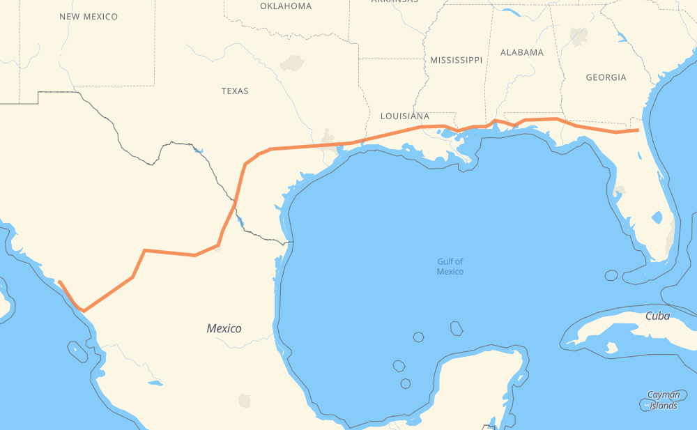
The distance from Jacksonville to San Diego is 3,167 kilometers by road including 2,811 kilometers on motorways. Road takes approximately 31 hours and 1 minute and goes through Tallahassee, Pensacola, Mobile, Biloxi, Gulfport, Denham Springs and Baton Rouge.

There are tolls on the route.
Shortest distance by air 2,615 km ✈️
Car route length 3,167 km 🚗
Driving time 31 h 1 min
Fuel amount 253.3 L
Fuel cost 496.5 CAD
Toll roads cost 1,634 + ? MXN
Click here to load the interactive map
Compare this route in other services:
City
Town
Village
Hamlet
Motorway
Primary
Secondary
Unclassified
Point Distance Time Fuel
Jacksonville 0 km 0:00 00 min 0.0 L
I 10 254 km, 2 h 21 min
Tallahassee 254 km 2:21 2 h 21 min 19.0 L
I 10 400 km, 3 h 40 min
Mobile 654 km 6:02 6 h 02 min 51.5 L
I 10 94 km, 51 min
Biloxi 748 km 6:53 6 h 53 min 59.4 L
I 10 11 km, 06 min
Gulfport 759 km 7:00 7 h 00 min 60.2 L
I 10 I 12 187 km, 1 h 41 min
Denham Springs 946 km 8:42 8 h 42 min 75.3 L
I 12 16 km, 10 min
Baton Rouge 961 km 8:52 8 h 52 min 76.0 L
I 12 I 10 209 km, 2 h 02 min
Lake Charles 1,170 km 10:54 10 h 54 min 93.2 L
I 10 92 km, 51 min
Beaumont 1,262 km 11:46 11 h 46 min 100.6 L
I 10 138 km, 1 h 19 min
Houston 1,400 km 13:06 13 h 06 min 111.5 L
I 10 312 km, 2 h 54 min
San Antonio 1,712 km 16:00 16 h 00 min 136.7 L
I 10 I 35 236 km, 2 h 09 min
Laredo 1,948 km 18:10 18 h 10 min 154.6 L
US 83 16 km, 09 min
Nuevo Laredo 1,964 km 18:19 18 h 19 min 157.0 L
MEX 85 MEX 40D 1,114 km, 11 h 32 min
Dimas (Estación Dimas) 3,077 km 29:52 29 h 52 min 245.1 L
MEX 15D 99 km, 1 h 09 min
San Diego 3,176 km 31:01 31 h 01 min 253.2 L
City
Town
Village
Hamlet
Motorway
Primary
Secondary
Unclassified
Point Distance Time Fuel
Jacksonville 0 km 0:00 00 min 0.0 L
I 10 254 km, 2 h 21 min
Tallahassee 254 km 2:21 2 h 21 min 19.0 L
I 10 28 km, 15 min
Midway 282 km 2:36 2 h 36 min 22.2 L
I 10 14 km, 07 min
Quincy 297 km 2:44 2 h 44 min 23.0 L
I 10 73 km, 39 min
Marianna 370 km 3:24 3 h 24 min 29.0 L
I 10 16 km, 08 min
Chipley 385 km 3:32 3 h 32 min 30.2 L
I 10 111 km, 1 h 00 min
Crestview 497 km 4:33 4 h 33 min 39.3 L
I 10 63 km, 34 min
Ferry Pass 560 km 5:07 5 h 07 min 44.4 L
I 10 9 km, 05 min
Brent 569 km 5:13 5 h 13 min 45.5 L
I 10 64 km, 35 min
Daphne 633 km 5:49 5 h 49 min 49.9 L
I 10 21 km, 12 min
Mobile 654 km 6:01 6 h 01 min 51.5 L
I 10 50 km, 27 min
Moss Point 703 km 6:29 6 h 29 min 56.0 L
I 10 12 km, 06 min
Gautier 715 km 6:36 6 h 36 min 56.6 L
I 10 32 km, 17 min
Biloxi 748 km 6:53 6 h 53 min 59.4 L
I 10 11 km, 06 min
Gulfport 759 km 6:59 6 h 59 min 60.2 L
I 10 40 km, 21 min
Bay Saint Louis 799 km 7:21 7 h 21 min 63.3 L
I 10 29 km, 15 min
New Country Club 828 km 7:37 7 h 37 min 66.1 L
I 12 2 km, 01 min
Hyde Park 830 km 7:38 7 h 38 min 66.4 L
I 12 3 km, 01 min
Woodlawn Acres 833 km 7:40 7 h 40 min 66.4 L
I 12 94 km, 51 min
Livingston 926 km 8:31 8 h 31 min 73.8 L
I 12 19 km, 10 min
Denham Springs 946 km 8:41 8 h 41 min 75.3 L
I 12 16 km, 10 min
Baton Rouge 961 km 8:51 8 h 51 min 76.0 L
I 12 13 km, 08 min
Port Allen 974 km 9:00 9 h 00 min 77.8 L
I 10 20 km, 12 min
Grosse Tete 995 km 9:13 9 h 13 min 79.4 L
I 10 21 km, 13 min
Ramah 1,015 km 9:26 9 h 26 min 80.0 L
I 10 59 km, 35 min
Rayne 1,075 km 10:01 10 h 01 min 84.7 L
I 10 16 km, 08 min
Crowley 1,091 km 10:10 10 h 10 min 87.2 L
I 10 26 km, 14 min
Jennings 1,117 km 10:24 10 h 24 min 89.0 L
I 10 38 km, 20 min
Iowa 1,155 km 10:45 10 h 45 min 91.9 L
I 10 16 km, 09 min
Lake Charles 1,170 km 10:54 10 h 54 min 93.2 L
I 10 10 km, 06 min
Rose Bluff 1,181 km 11:00 11 h 00 min 94.4 L
I 10 8 km, 04 min
Sulphur 1,189 km 11:05 11 h 05 min 94.8 L
I 10 28 km, 15 min
Toomey 1,216 km 11:20 11 h 20 min 97.1 L
I 10 21 km, 11 min
Stark 1,237 km 11:31 11 h 31 min 98.9 L
I 10 11 km, 05 min
Vidor 1,248 km 11:37 11 h 37 min 99.3 L
I 10 8 km, 04 min
Rose City 1,256 km 11:42 11 h 42 min 100.4 L
I 10 6 km, 03 min
Beaumont 1,262 km 11:45 11 h 45 min 100.6 L
I 10 81 km, 46 min
Cove 1,344 km 12:32 12 h 32 min 107.5 L
I 10 43 km, 24 min
Jacinto City 1,386 km 12:56 12 h 56 min 110.8 L
I 10 14 km, 08 min
Houston 1,400 km 13:05 13 h 05 min 111.5 L
I 10 I 10 Toll 12 km, 07 min
Hilshire Village 1,412 km 13:13 13 h 13 min 112.9 L
I 10 Toll 2 km, 01 min
Hedwig Village 1,415 km 13:14 13 h 14 min 113.1 L
I 10 Toll 12 km, 07 min
Addicks 1,426 km 13:21 13 h 21 min 114.1 L
I 10 Toll 4 km, 02 min
Barker 1,430 km 13:24 13 h 24 min 114.4 L
I 10 17 km, 09 min
Katy 1,447 km 13:34 13 h 34 min 115.4 L
I 10 11 km, 06 min
Brookshire 1,458 km 13:40 13 h 40 min 116.5 L
I 10 12 km, 06 min
San Felipe Siding 1,470 km 13:47 13 h 47 min 117.3 L
I 10 31 km, 17 min
Alleyton 1,502 km 14:04 14 h 04 min 119.3 L
I 10 14 km, 07 min
Columbus 1,515 km 14:12 14 h 12 min 121.0 L
I 10 15 km, 08 min
Weimar 1,531 km 14:20 14 h 20 min 121.5 L
I 10 44 km, 23 min
Flatonia 1,575 km 14:44 14 h 44 min 125.6 L
I 10 18 km, 09 min
Waelder 1,593 km 14:54 14 h 54 min 127.0 L
I 10 64 km, 34 min
Seguin 1,656 km 15:28 15 h 28 min 131.5 L
I 10 18 km, 09 min
Cibolo 1,674 km 15:38 15 h 38 min 133.5 L
I 10 7 km, 03 min
Friendly Corner 1,681 km 15:42 15 h 42 min 134.4 L
I 10 31 km, 17 min
San Antonio 1,712 km 15:59 15 h 59 min 136.7 L
I 10 I 35 22 km, 12 min
Von Ormy 1,734 km 16:12 16 h 12 min 138.6 L
I 35 14 km, 07 min
Lytle 1,749 km 16:20 16 h 20 min 139.8 L
I 35 30 km, 16 min
Moore 1,779 km 16:37 16 h 37 min 142.0 L
I 35 29 km, 15 min
Melon 1,808 km 16:52 16 h 52 min 144.1 L
I 35 6 km, 03 min
Derby 1,814 km 16:56 16 h 56 min 145.1 L
I 35 22 km, 11 min
Millett 1,836 km 17:08 17 h 08 min 146.8 L
I 35 8 km, 04 min
Gardendale 1,844 km 17:12 17 h 12 min 146.9 L
I 35 26 km, 14 min
Artesia Wells 1,870 km 17:26 17 h 26 min 149.4 L
I 35 27 km, 14 min
Encinal 1,897 km 17:41 17 h 41 min 151.4 L
I 35 17 km, 09 min
San Ramon 1,914 km 17:50 17 h 50 min 152.8 L
I 35 5 km, 02 min
Callaghan 1,919 km 17:53 17 h 53 min 153.4 L
I 35 9 km, 04 min
Webb 1,928 km 17:57 17 h 57 min 154.2 L
I 35 3 km, 01 min
Botines 1,930 km 17:59 17 h 59 min 154.2 L
I 35 18 km, 10 min
Laredo 1,948 km 18:09 18 h 09 min 154.6 L
US 83 16 km, 09 min
Nuevo Laredo 1,964 km 18:18 18 h 18 min 157.0 L
MEX 85 MEX 85D 218 km, 2 h 10 min
General Escobedo 2,182 km 20:29 20 h 29 min 174.4 L
NL 100D 1610 43 km, 25 min
Rinconada 2,225 km 20:54 20 h 54 min 177.9 L
MEX 40D 89 km, 55 min
Ejido Independencia 2,314 km 21:50 21 h 50 min 184.9 L
MEX 40D 75 km, 42 min
28 de Agosto 2,389 km 22:33 22 h 33 min 190.3 L
MEX 40 23 km, 15 min
El Mimbre 2,412 km 22:48 22 h 48 min 192.3 L
MEX 40 MEX 40D 157 km, 1 h 37 min
La Lomas 2,569 km 24:25 24 h 25 min 204.7 L
MEX 40D 22 km, 11 min
Margarito Machado 2,590 km 24:37 24 h 37 min 206.3 L
MEX 40D 23 km, 12 min
Vista Hermosa 2,614 km 24:50 24 h 50 min 208.3 L
MEX 40D 40 km, 22 min
Yerbanis 2,654 km 25:12 25 h 12 min 211.8 L
MEX 40D 35 km, 18 min
Ignacio Ramirez 2,689 km 25:31 25 h 31 min 214.7 L
MEX 40D 57 km, 30 min
Los Caballeros 2,745 km 26:02 26 h 02 min 219.6 L
MEX 40D 3 km, 01 min
Familia Torrecillas 2,748 km 26:03 26 h 03 min 219.8 L
MEX 40D 87 km, 1 h 02 min
Llano Grande 2,835 km 27:05 27 h 05 min 226.6 L
MEX 40D 23 km, 16 min
El Salto 2,857 km 27:22 27 h 22 min 228.0 L
MEX 40D 10 km, 06 min
Lechería 2,867 km 27:28 27 h 28 min 229.2 L
MEX 40D 5 km, 02 min
Las Adjuntas 2,872 km 27:31 27 h 31 min 229.6 L
MEX 40D 8 km, 05 min
Coscomate 2,880 km 27:36 27 h 36 min 230.3 L
MEX 40D 34 km, 24 min
El Baluarte 2,914 km 28:01 28 h 01 min 233.1 L
MEX 40D 17 km, 12 min
Corte Alto 2,931 km 28:13 28 h 13 min 234.4 L
MEX 40D 1 km, 01 min
Chirimoyos 2,932 km 28:14 28 h 14 min 234.6 L
MEX 40D 2 km, 01 min
Santa Lucia 2,934 km 28:16 28 h 16 min 234.6 L
MEX 40D 7 km, 04 min
Pánuco 2,941 km 28:21 28 h 21 min 235.2 L
MEX 40D 6 km, 04 min
El Naranjito 2,947 km 28:25 28 h 25 min 235.7 L
MEX 40D 6 km, 04 min
Chupaderos 2,953 km 28:30 28 h 30 min 236.1 L
MEX 40D 8 km, 05 min
Zapotillo 2,960 km 28:35 28 h 35 min 236.7 L
MEX 40D 17 km, 12 min
Ejido Caleritas 2,978 km 28:47 28 h 47 min 237.6 L
MEX 40D MEX 15D 100 km, 1 h 02 min
Dimas (Estación Dimas) 3,077 km 29:50 29 h 50 min 245.1 L
MEX 15D 26 km, 18 min
Ceuta 3,103 km 30:08 30 h 08 min 247.9 L
MEX 15D 7 km, 05 min
Abocho (Estación Abocho) 3,110 km 30:13 30 h 13 min 248.5 L
MEX 15D 11 km, 08 min
Tanques 3,121 km 30:21 30 h 21 min 249.2 L
MEX 15D 13 km, 09 min
Ricardo Flores Magón 3,134 km 30:30 30 h 30 min 250.5 L
MEX 15D 11 km, 07 min
Abuya y Ceuta Segunda (Ejido Echeverría) 3,145 km 30:38 30 h 38 min 251.4 L
MEX 15D 31 km, 21 min
San Diego 3,176 km 30:59 30 h 59 min 253.2 L

Frequently Asked Questions

How many toll booths are there from Jacksonville to San Diego?

How much does the toll booths cost from Jacksonville to San Diego?

Toll roads cost: Sabinas (273 MXN) + Lincoln (168 MXN) + Periférico (72 MXN) + Ojo Caliente (?) + Torreon (17 MXN) + Plan de Ayala (139 MXN) + La Cuchilla (79 MXN) + San Pedro km 16+830 (?) + León Guzmán (?) + Cuencame (?) + Yerbanis (?) + Durango (?) + Durango 95 (67 MXN) + Llano Grande (100 MXN) + Coscomate (315 MXN) + Mesillas (166 MXN) + Marmol (131 MXN) + Quila (107 MXN) = 1,634 + ? MXN

How much does it cost to drive from Jacksonville to San Diego?

Fuel cost: 496.5 CAD

This fuel cost is calculated as: (Route length 3,167 km / 100 km) * (Fuel consumption 8 L/100 km) * (Fuel price 1.96 CAD / L)

You can adjust fuel consumption and fuel price here.

Toll roads cost: 1,634 + ? MXN

How long is a car ride from Jacksonville to San Diego?

Driving time: 31 h 1 min

This time is calculated for driving at the maximum permitted speed, taking into account traffic rules restrictions.

  • 2,044 km with a maximum speed 110 km/h = 18 h 34 min
  • 157 km with a maximum speed 105 km/h = 1 h 30 min
  • 296 km with a maximum speed 100 km/h = 2 h 57 min
  • 108 km with a maximum speed 97 km/h = 1 h 7 min
  • 326 km with a maximum speed 90 km/h = 3 h 37 min
  • 19 km with a maximum speed 89 km/h = 12 min
  • 2 km with a maximum speed 80 km/h = 1 min
  • 204 km with a maximum speed 80 km/h = 2 h 33 min
  • 11 km with a maximum speed 60 km/h = 10 min
  • 2 km with a maximum speed 56 km/h = 1 min
  • 3 km with a maximum speed 50 km/h = 3 min
  • 1 km with a maximum speed 20 km/h = 2 min
  • 1 km with a maximum speed 10 km/h = 6 min

The calculated driving time does not take into account intermediate stops and traffic jams.

How far is Jacksonville to San Diego by land?

The distance between Jacksonville and San Diego is 3,167 km by road including 2,811 km on motorways.

Precise satellite coordinates of highways were used for this calculation. The start and finish points are the centers of Jacksonville and San Diego respectively.

How far is Jacksonville to San Diego by plane?

The shortest distance (air line, as the crow flies) between Jacksonville and San Diego is 2,615 km.

This distance is calculated using the Haversine formula as a great-circle distance between two points on the surface of a sphere. The start and finish points are the centers of Jacksonville and San Diego respectively. Actual distance between airports may be different.

How many hours is Jacksonville from San Diego by plane?

Boeing 737 airliner needs 3 h 16 min to cover the distance of 2,615 km at a cruising speed of 800 km/h.

Small plane "Cessna 172" needs 11 h 53 min to flight this distance at average speed of 220 km/h.

This time is approximate and do not take into account takeoff and landing times, airport location and other real world factors.

How long is a helicopter ride from Jacksonville to San Diego?

Fast helicopter "Eurocopter AS350" or "Hughes OH-6 Cayuse" need 10 h 53 min to cover the distance of 2,615 km at a cruising speed of 240 km/h.

Popular "Robinson R44" needs 12 h 27 min to flight this distance at average speed of 210 km/h.

This time is approximate and do not take into account takeoff and landing times, aerodrome location and other real world factors.

What city is halfway between Jacksonville and San Diego?

The halfway point between Jacksonville and San Diego is Flatonia. It is located about 9 km from the exact midpoint by road.

The distance from Flatonia to Jacksonville is 1,575 km and driving will take about 14 h 44 min. The road between Flatonia and San Diego has length 1,592 km and will take approximately 16 h 17 min.

The other cities located close to halfway point:

Where is Jacksonville in relation to San Diego?

Jacksonville is located 2,615 km east of San Diego.

Jacksonville has geographic coordinates: latitude 30.33218, longitude -81.65565.

San Diego has geographic coordinates: latitude 24.38271, longitude -107.33077.

Which highway goes from Jacksonville to San Diego?

The route from Jacksonville to San Diego follows I 10, MEX 40D, I 35, MEX 15D, US 90, I 12, MEX 40, MEX 85D.

Other minor sections pass along the road:

  • MEX 85: 90 km
  • MEX 49D: 85 km
  • TX 130: 53 km
  • 1610: 38 km
  • US 83: 28 km
  • MEX 2: 24 km
  • NL 100D: 22 km
  • I 10 Toll: 19 km
  • NL 100: 15 km
  • Sin 326: 7 km
  • US 87: 6 km
  • US 287: 4 km
  • US 96: 4 km
  • US 69: 4 km
  • US 17: 3 km
  • FL 228: 3 km
  • MEX 40D:MEX 49D: 3 km
  • TX 71: 2 km
  • I 95: 2 km
  • US 23: 1 km
  • I 35-A Business: 1 km
The distance between Jacksonville and San Diego is ranked 38,068th in the ranking popularity.
Have any questions? Contact us!