Distance between Itumirim and Valença
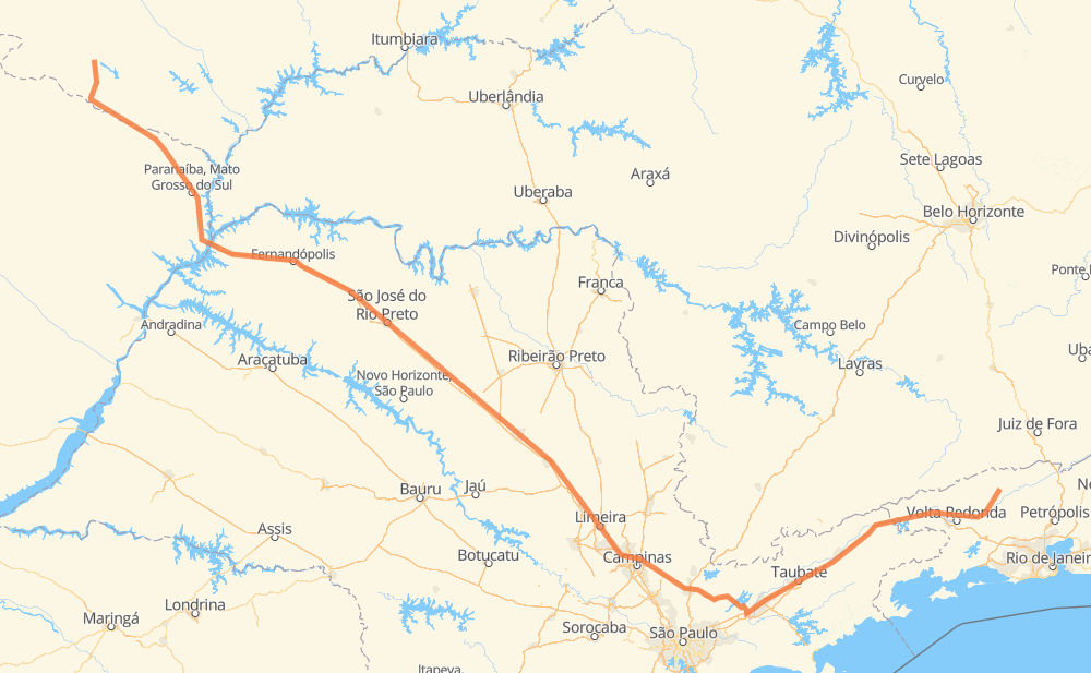
The distance from Itumirim to Valença is 1,236 kilometers by road including 911 kilometers on motorways. Road takes approximately 12 hours and 39 minutes and goes through Rio Claro, Itatiba, Atibaia, Jacareí and Guaratinguetá.
| Shortest distance by air | 968 km ✈️ |
| Car route length | 1,236 km 🚗 |
| Driving time | 12 h 39 min |
| Fuel amount | 98.9 L |
| Fuel cost | 190.8 CAD |
| Point | Distance | Time | Fuel | |
| Itumirim | 0 km | 00 min | 0.0 L | |
|
GO-184 BR-158 341 km, 3 h 37 min
|
||||
| Conjunto Habitacional Antônio Marin | 341 km | 3 h 37 min | 27.1 L | |
|
SP-320 71 km, 38 min
|
||||
| Jardim Santa Mônica | 412 km | 4 h 16 min | 32.9 L | |
|
SP-320 26 km, 14 min
|
||||
| Bairro São Pedro | 438 km | 4 h 30 min | 34.8 L | |
|
SP-310 40 km, 23 min
|
||||
| Distrito Industrial II | 478 km | 4 h 54 min | 37.9 L | |
|
SP-310 238 km, 2 h 19 min
|
||||
| Rio Claro | 716 km | 7 h 14 min | 56.8 L | |
|
SP-310 SP-330 113 km, 1 h 07 min
|
||||
| Itatiba | 829 km | 8 h 22 min | 65.8 L | |
|
SP-065 26 km, 14 min
|
||||
| Atibaia | 855 km | 8 h 36 min | 67.4 L | |
|
SP-065 80 km, 46 min
|
||||
| Jacareí | 935 km | 9 h 23 min | 74.5 L | |
|
SP-060 BR-116 99 km, 58 min
|
||||
| Guaratinguetá | 1,034 km | 10 h 21 min | 82.5 L | |
|
SP-060 BR-116 202 km, 2 h 18 min
|
||||
| -22.24610, -43.69969 | 1,236 km | 12 h 39 min | 98.9 L | |
Frequently Asked Questions
How much does it cost to drive from Itumirim to Valença?
Fuel cost: 190.8 CAD
This fuel cost is calculated as: (Route length 1,236 km / 100 km) * (Fuel consumption 8 L/100 km) * (Fuel price 1.93 CAD / L)
You can adjust fuel consumption and fuel price here.
How long is a car ride from Itumirim to Valença?
Driving time: 12 h 39 min
This time is calculated for driving at the maximum permitted speed, taking into account traffic rules restrictions.
- 652 km with a maximum speed 110 km/h = 5 h 55 min
- 186 km with a maximum speed 100 km/h = 1 h 51 min
- 300 km with a maximum speed 90 km/h = 3 h 19 min
- 45 km with a maximum speed 80 km/h = 33 min
- 23 km with a maximum speed 70 km/h = 20 min
- 9 km with a maximum speed 60 km/h = 9 min
- 8 km with a maximum speed 50 km/h = 9 min
- 13 km with a maximum speed 40 km/h = 19 min
- 1 km with a maximum speed 30 km/h = 1 min
The calculated driving time does not take into account intermediate stops and traffic jams.
How far is Itumirim to Valença by land?
The distance between Itumirim and Valença is 1,236 km by road including 911 km on motorways.
Precise satellite coordinates of highways were used for this calculation. The start and finish points are the centers of Itumirim and Valença respectively.
How far is Itumirim to Valença by plane?
The shortest distance (air line, as the crow flies) between Itumirim and Valença is 968 km.
This distance is calculated using the Haversine formula as a great-circle distance between two points on the surface of a sphere. The start and finish points are the centers of Itumirim and Valença respectively. Actual distance between airports may be different.
How many hours is Itumirim from Valença by plane?
Boeing 737 airliner needs 1 h 12 min to cover the distance of 968 km at a cruising speed of 800 km/h.
Small plane "Cessna 172" needs 4 h 24 min to flight this distance at average speed of 220 km/h.
This time is approximate and do not take into account takeoff and landing times, airport location and other real world factors.
How long is a helicopter ride from Itumirim to Valença?
Fast helicopter "Eurocopter AS350" or "Hughes OH-6 Cayuse" need 4 h 2 min to cover the distance of 968 km at a cruising speed of 240 km/h.
Popular "Robinson R44" needs 4 h 36 min to flight this distance at average speed of 210 km/h.
This time is approximate and do not take into account takeoff and landing times, aerodrome location and other real world factors.
What city is halfway between Itumirim and Valença?
The halfway point between Itumirim and Valença is Jardim Araucária. It is located about 29 km from the exact midpoint by road.
The distance from Jardim Araucária to Itumirim is 647 km and driving will take about 6 h 32 min. The road between Jardim Araucária and Valença has length 588 km and will take approximately 6 h 7 min.
The other cities located close to halfway point:
Where is Itumirim in relation to Valença?
Itumirim is located 968 km north-west of Valença.
Itumirim has geographic coordinates: latitude -18.51876, longitude -52.09285.
Valença has geographic coordinates: latitude -22.2461, longitude -43.69969.
Which highway goes from Itumirim to Valença?
The route from Itumirim to Valença follows SP-310, BR-116, SP-320, SP-060, BR-158, SP-065, BR-364.
Other minor sections pass along the road:
- GO-184: 65 km
- BR-267: 59 km
- BR-050: 49 km
- SP-330: 49 km
- BR-393: 35 km
- RJ-145: 32 km
- GO-302: 27 km
- BR-459: 14 km
- BR-383: 11 km
- BR-436: 2 km
- RJ-157: 1 km