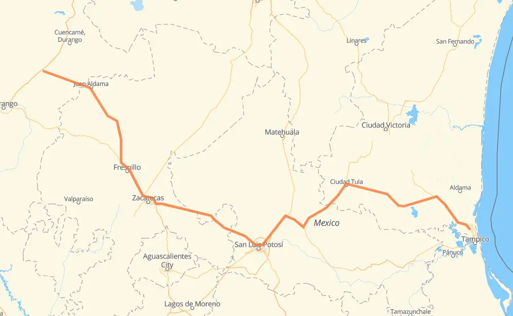
Distance between Ignacio Ramirez and Altamira
The distance from Ignacio Ramirez to Altamira is 909 kilometers by road including 92 kilometers on motorways. Road takes approximately 10 hours and 31 minutes and goes through Fresnillo, Guadalupe, Emiliano Zapata, Cinco de Mayo, Río Grande, Víctor Rosales and Hacienda Nueva.
| Shortest distance by air | 670 km ✈️ |
| Car route length | 909 km 🚗 |
| Driving time | 10 h 31 min |
| Fuel amount | 72.7 L |
| Fuel cost | 144 CAD |
| Toll roads cost | 111 + ? MXN |
| Point | Distance | Time | Fuel | |
| Ignacio Ramirez | 0 km | 00 min | 0.0 L | |
|
MEX 40 42 km, 31 min
|
||||
| Emiliano Zapata | 42 km | 31 min | 1.2 L | |
|
DGO 386 MEX 49 103 km, 1 h 14 min
|
||||
| Río Grande | 145 km | 1 h 45 min | 11.0 L | |
|
MEX 49 80 km, 51 min
|
||||
| Fresnillo | 224 km | 2 h 37 min | 17.2 L | |
|
MEX 45D MEX 45 33 km, 19 min
|
||||
| Víctor Rosales | 257 km | 2 h 57 min | 20.2 L | |
|
MEX 45D MEX 45 18 km, 12 min
|
||||
| Hacienda Nueva | 275 km | 3 h 09 min | 21.8 L | |
|
MEX 45D 27 km, 19 min
|
||||
| Troncoso | 302 km | 3 h 28 min | 23.6 L | |
|
MEX 45 MEX 49 351 km, 3 h 57 min
|
||||
| Ciudad Tula | 654 km | 7 h 26 min | 51.8 L | |
|
MEX 101 TAM 66 60 km, 44 min
|
||||
| Ciudad Ocampo | 714 km | 8 h 10 min | 57.0 L | |
|
TAM 116 MEX 80 195 km, 2 h 20 min
|
||||
| Altamira | 909 km | 10 h 31 min | 72.1 L | |
Hotels of Altamira
Frequently Asked Questions
How many toll booths are there from Ignacio Ramirez to Altamira?
There are 4 toll booths between Ignacio Ramirez and Altamira: Morfín Chávez, Calera, Veta Grande and La Hincada.
How much does the toll booths cost from Ignacio Ramirez to Altamira?
Toll roads cost: Morfín Chávez (40 MXN) + Calera (23 MXN) + Veta Grande (48 MXN) + La Hincada (?) = 111 + ? MXN
How much does it cost to drive from Ignacio Ramirez to Altamira?
Fuel cost: 144 CAD
This fuel cost is calculated as: (Route length 909 km / 100 km) * (Fuel consumption 8 L/100 km) * (Fuel price 1.98 CAD / L)
You can adjust fuel consumption and fuel price here.
Toll roads cost: 111 + ? MXN
How long is a car ride from Ignacio Ramirez to Altamira?
Driving time: 10 h 31 min
This time is calculated for driving at the maximum permitted speed, taking into account traffic rules restrictions.
- 31 km with a maximum speed 110 km/h = 16 min
- 8 km with a maximum speed 100 km/h = 4 min
- 587 km with a maximum speed 90 km/h = 6 h 31 min
- 264 km with a maximum speed 80 km/h = 3 h 17 min
- 3 km with a maximum speed 70 km/h = 2 min
- 15 km with a maximum speed 60 km/h = 14 min
- 2 km with a maximum speed 50 km/h = 2 min
The calculated driving time does not take into account intermediate stops and traffic jams.
How far is Ignacio Ramirez to Altamira by land?
The distance between Ignacio Ramirez and Altamira is 909 km by road including 92 km on motorways.
Precise satellite coordinates of highways were used for this calculation. The start and finish points are the centers of Ignacio Ramirez and Altamira respectively.
How far is Ignacio Ramirez to Altamira by plane?
The shortest distance (air line, as the crow flies) between Ignacio Ramirez and Altamira is 670 km.
This distance is calculated using the Haversine formula as a great-circle distance between two points on the surface of a sphere. The start and finish points are the centers of Ignacio Ramirez and Altamira respectively. Actual distance between airports may be different.
How many hours is Ignacio Ramirez from Altamira by plane?
Boeing 737 airliner needs 50 min to cover the distance of 670 km at a cruising speed of 800 km/h.
Small plane "Cessna 172" needs 3 h 2 min to flight this distance at average speed of 220 km/h.
This time is approximate and do not take into account takeoff and landing times, airport location and other real world factors.
How long is a helicopter ride from Ignacio Ramirez to Altamira?
Fast helicopter "Eurocopter AS350" or "Hughes OH-6 Cayuse" need 2 h 47 min to cover the distance of 670 km at a cruising speed of 240 km/h.
Popular "Robinson R44" needs 3 h 11 min to flight this distance at average speed of 210 km/h.
This time is approximate and do not take into account takeoff and landing times, aerodrome location and other real world factors.
What city is halfway between Ignacio Ramirez and Altamira?
The halfway point between Ignacio Ramirez and Altamira is Rincón del Porvenir. It is located about 33 km from the exact midpoint by road.
The distance from Rincón del Porvenir to Ignacio Ramirez is 421 km and driving will take about 4 h 48 min. The road between Rincón del Porvenir and Altamira has length 488 km and will take approximately 5 h 43 min.
The other cities located close to halfway point:
Where is Ignacio Ramirez in relation to Altamira?
Ignacio Ramirez is located 670 km north-west of Altamira.
Ignacio Ramirez has geographic coordinates: latitude 24.50799, longitude -104.08829.
Altamira has geographic coordinates: latitude 22.40551, longitude -97.93189.
Which highway goes from Ignacio Ramirez to Altamira?
The route from Ignacio Ramirez to Altamira follows MEX 49, MEX 80.
Other minor sections pass along the road:
- TAM 66: 97 km
- DGO 386: 59 km
- MEX 57: 58 km
- MEX 45D: 56 km
- MEX 180: 52 km
- SLP 80CE: 51 km
- MEX 45: 44 km
- MEX 101: 42 km
- SLP 75D: 31 km
- MEX 81: 27 km
- MEX 85: 16 km
- ZAC 386: 11 km
- SLP 32: 11 km
- MEX 40: 5 km
- TAM 116: 3 km
- MEX 54: 1 km