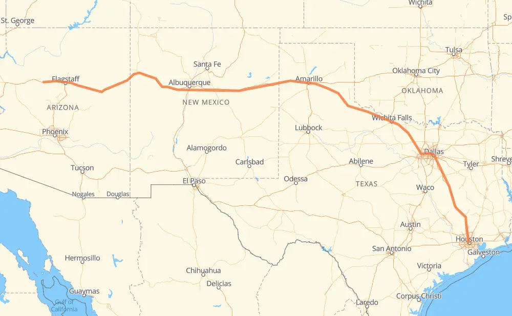
The distance from Houston to Pinaveta is 2,033 kilometers by road including 1,641 kilometers on motorways. Road takes approximately 20 hours and 13 minutes and goes through Dallas, Irving, Amarillo and Flagstaff.
How much does it cost to drive from Houston to Pinaveta?
Fuel cost:
318.7 CAD
This fuel cost is calculated as: (Route length 2,033 km / 100 km) * (Fuel consumption 8 L/100 km) * (Fuel price 1.96 CAD / L)
You can adjust fuel consumption and fuel price here.
How long is a car ride from Houston to Pinaveta?
Driving time:
20 h 13 min
This time is calculated for driving at the maximum permitted speed, taking into account traffic rules restrictions.
1,129 km with a maximum speed 110 km/h = 10 h 15 min
123 km with a maximum speed 105 km/h = 1 h 10 min
214 km with a maximum speed 100 km/h = 2 h 8 min
52 km with a maximum speed 97 km/h = 32 min
239 km with a maximum speed 90 km/h = 2 h 39 min
3 km with a maximum speed 89 km/h = 2 min
270 km with a maximum speed 80 km/h = 3 h 22 min
2 km with a maximum speed 64 km/h = 1 min
The calculated driving time does not take into account intermediate stops and traffic jams.
How far is Houston to Pinaveta by land?
The distance between Houston and Pinaveta is 2,033 km by road including 1,641 km on motorways.
Precise satellite coordinates of highways were used for this calculation. The start and finish points are the centers of Houston and Pinaveta respectively.
How far is Houston to Pinaveta by plane?
The shortest distance (air line, as the crow flies) between Houston and Pinaveta is 1,722 km.
This distance is calculated using the Haversine formula as a great-circle distance between two points on the surface of a sphere. The start and finish points are the centers of Houston and Pinaveta respectively. Actual distance between airports may be different.
How many hours is Houston from Pinaveta by plane?
Boeing 737 airliner needs 2 h 9 min to cover the distance of 1,722 km at a cruising speed of 800 km/h.
Small plane "Cessna 172" needs 7 h 49 min to flight this distance at average speed of 220 km/h.
This time is approximate and do not take into account takeoff and landing times, airport location and other real world factors.
How long is a helicopter ride from Houston to Pinaveta?
Fast helicopter "Eurocopter AS350" or "Hughes OH-6 Cayuse" need 7 h 10 min to cover the distance of 1,722 km at a cruising speed of 240 km/h.
Popular "Robinson R44" needs 8 h 11 min to flight this distance at average speed of 210 km/h.
This time is approximate and do not take into account takeoff and landing times, aerodrome location and other real world factors.
What city is halfway between Houston and Pinaveta?
The halfway point between Houston and Pinaveta is Vega. It is located about 5 km from the exact midpoint by road.
The distance from Vega to Houston is 1,022 km and driving will take about 10 h 59 min. The road between Vega and Pinaveta has length 1,011 km and will take approximately 9 h 14 min.
The other cities located close to halfway point:
Wildorado is in 1,005 km from Houston and 1,028 km from Pinaveta
Landergin is in 1,034 km from Houston and 999 km from Pinaveta
Bushland is in 987 km from Houston and 1,045 km from Pinaveta
Where is Houston in relation to Pinaveta?
Houston is located 1,722 km south-east of Pinaveta.
Houston has geographic coordinates: latitude 29.75894, longitude -95.3677.
Pinaveta has geographic coordinates: latitude 35.22723, longitude -112.57296.
Which highway goes from Houston to Pinaveta?
The route from Houston to Pinaveta follows I 40, US 287, I 45, US 180.