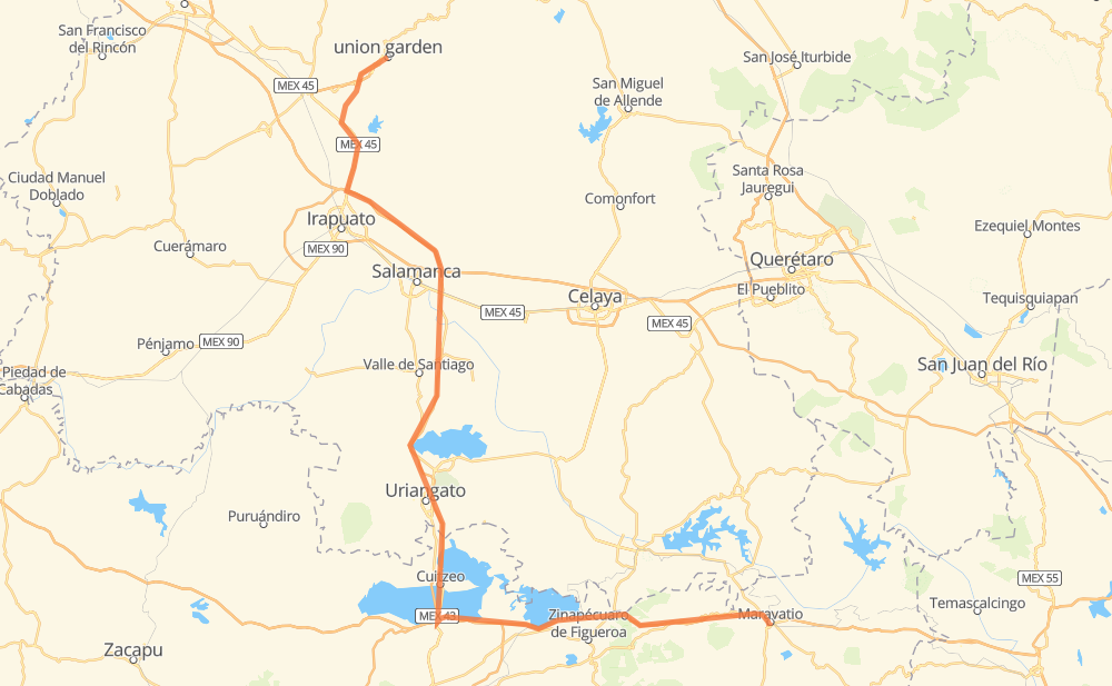
Distance between Guanajuato and Maravatio
The distance from Guanajuato to Maravatio is 231 kilometers by road including 105 kilometers on motorways. Road takes approximately 2 hours and 33 minutes and goes through Mendoza, Santa Teresa and Ex-Hacienda del Copal.
| Shortest distance by air | 151 km ✈️ |
| Car route length | 231 km 🚗 |
| Driving time | 2 h 33 min |
| Fuel amount | 18.4 L |
| Fuel cost | 36.1 CAD |
| Toll roads cost | 214 + ? MXN |
| Point | Distance | Time | Fuel | |
| Guanajuato | 0 km | 00 min | 0.0 L | |
|
MEX 110 13 km, 13 min
|
||||
| Santa Teresa | 13 km | 13 min | 0.9 L | |
|
MEX 110 MEX 45 28 km, 19 min
|
||||
| Ex-Hacienda del Copal | 41 km | 32 min | 3.3 L | |
|
MEX 45 MEX 43D 10 km, 06 min
|
||||
| Mendoza | 51 km | 38 min | 3.3 L | |
|
MEX 43D 182 km, 1 h 54 min
|
||||
| Maravatio | 233 km | 2 h 33 min | 17.8 L | |
Frequently Asked Questions
How many toll booths are there from Guanajuato to Maravatio?
There are 4 toll booths between Guanajuato and Maravatio: Mendoza, Entronque Valtierrilla, La Cinta and Zinapecuaro.
How much does the toll booths cost from Guanajuato to Maravatio?
Toll roads cost: Mendoza (53 MXN) + Entronque Valtierrilla (?) + La Cinta (?) + Zinapecuaro (161 MXN) = 214 + ? MXN
How much does it cost to drive from Guanajuato to Maravatio?
Fuel cost: 36.1 CAD
This fuel cost is calculated as: (Route length 231 km / 100 km) * (Fuel consumption 8 L/100 km) * (Fuel price 1.96 CAD / L)
You can adjust fuel consumption and fuel price here.
Toll roads cost: 214 + ? MXN
How long is a car ride from Guanajuato to Maravatio?
Driving time: 2 h 33 min
This time is calculated for driving at the maximum permitted speed, taking into account traffic rules restrictions.
- 36 km with a maximum speed 110 km/h = 19 min
- 61 km with a maximum speed 100 km/h = 36 min
- 110 km with a maximum speed 90 km/h = 1 h 13 min
- 15 km with a maximum speed 80 km/h = 11 min
- 3 km with a maximum speed 60 km/h = 3 min
- 6 km with a maximum speed 50 km/h = 7 min
- 1 km with a maximum speed 40 km/h = 1 min
The calculated driving time does not take into account intermediate stops and traffic jams.
How far is Guanajuato to Maravatio by land?
The distance between Guanajuato and Maravatio is 231 km by road including 105 km on motorways.
Precise satellite coordinates of highways were used for this calculation. The start and finish points are the centers of Guanajuato and Maravatio respectively.
How far is Guanajuato to Maravatio by plane?
The shortest distance (air line, as the crow flies) between Guanajuato and Maravatio is 151 km.
This distance is calculated using the Haversine formula as a great-circle distance between two points on the surface of a sphere. The start and finish points are the centers of Guanajuato and Maravatio respectively. Actual distance between airports may be different.
How many hours is Guanajuato from Maravatio by plane?
Boeing 737 airliner needs 11 min to cover the distance of 151 km at a cruising speed of 800 km/h.
Small plane "Cessna 172" needs 41 min to flight this distance at average speed of 220 km/h.
This time is approximate and do not take into account takeoff and landing times, airport location and other real world factors.
How long is a helicopter ride from Guanajuato to Maravatio?
Fast helicopter "Eurocopter AS350" or "Hughes OH-6 Cayuse" need 37 min to cover the distance of 151 km at a cruising speed of 240 km/h.
Popular "Robinson R44" needs 43 min to flight this distance at average speed of 210 km/h.
This time is approximate and do not take into account takeoff and landing times, aerodrome location and other real world factors.
Where is Guanajuato in relation to Maravatio?
Guanajuato is located 151 km north-west of Maravatio.
Guanajuato has geographic coordinates: latitude 21.01585, longitude -101.25287.
Maravatio has geographic coordinates: latitude 19.89421, longitude -100.44235.
Which highway goes from Guanajuato to Maravatio?
The route from Guanajuato to Maravatio follows MEX 43D, MEX 15D.
Other minor sections pass along the road:
- MEX 45: 17 km
- MEX 110: 11 km
- MEX 126: 2 km
- MEX 61: 2 km
- MEX 43: 1 km