Distance between Guaíra and Amambai
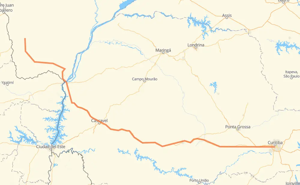
The distance from Guaíra to Amambai is 840 kilometers by road including 136 kilometers on motorways. Road takes approximately 9 hours and 35 minutes and goes through Campo Largo, Cascavel, Mercês, Distrito Industrial, Marechal Candido Rondon, Mundo Novo and Manoel Gomes da Silva.
| Shortest distance by air | 658 km ✈️ |
| Car route length | 840 km 🚗 |
| Driving time | 9 h 35 min |
| Fuel amount | 67.2 L |
| Fuel cost | 133 CAD |
| Point | Distance | Time | Fuel | |
| -25.47004, -49.27524 | 0 km | 00 min | 0.0 L | |
|
6 km, 04 min
|
||||
| Mercês | 6 km | 04 min | 0.8 L | |
|
BR-277 24 km, 15 min
|
||||
| Campo Largo | 30 km | 20 min | 2.3 L | |
|
BR-277 69 km, 48 min
|
||||
| Distrito Industrial | 99 km | 1 h 08 min | 6.2 L | |
|
BR-277 207 km, 2 h 29 min
|
||||
| Lagoa Seca | 306 km | 3 h 38 min | 24.7 L | |
|
BR-277 114 km, 1 h 17 min
|
||||
| São Judas Tadeu | 420 km | 4 h 55 min | 33.5 L | |
|
BR-277 79 km, 52 min
|
||||
| Cascavel | 498 km | 5 h 48 min | 39.8 L | |
|
BR-467 36 km, 19 min
|
||||
| Vista Alegre | 534 km | 6 h 07 min | 43.0 L | |
|
BR-163 43 km, 26 min
|
||||
| Marechal Candido Rondon | 577 km | 6 h 34 min | 46.3 L | |
|
BR-163 90 km, 1 h 02 min
|
||||
| Mundo Novo | 668 km | 7 h 37 min | 53.4 L | |
|
BR-163 36 km, 26 min
|
||||
| Manoel Gomes da Silva | 704 km | 8 h 04 min | 55.7 L | |
|
MS-295 135 km, 1 h 31 min
|
||||
| -23.10827, -55.22849 | 840 km | 9 h 35 min | 67.6 L | |
Frequently Asked Questions
How much does it cost to drive from Guaíra to Amambai?
Fuel cost: 133 CAD
This fuel cost is calculated as: (Route length 840 km / 100 km) * (Fuel consumption 8 L/100 km) * (Fuel price 1.98 CAD / L)
You can adjust fuel consumption and fuel price here.
How long is a car ride from Guaíra to Amambai?
Driving time: 9 h 35 min
This time is calculated for driving at the maximum permitted speed, taking into account traffic rules restrictions.
- 106 km with a maximum speed 110 km/h = 57 min
- 10 km with a maximum speed 100 km/h = 5 min
- 532 km with a maximum speed 90 km/h = 5 h 54 min
- 153 km with a maximum speed 80 km/h = 1 h 54 min
- 31 km with a maximum speed 60 km/h = 31 min
- 7 km with a maximum speed 40 km/h = 10 min
The calculated driving time does not take into account intermediate stops and traffic jams.
How far is Guaíra to Amambai by land?
The distance between Guaíra and Amambai is 840 km by road including 136 km on motorways.
Precise satellite coordinates of highways were used for this calculation. The start and finish points are the centers of Guaíra and Amambai respectively.
How far is Guaíra to Amambai by plane?
The shortest distance (air line, as the crow flies) between Guaíra and Amambai is 658 km.
This distance is calculated using the Haversine formula as a great-circle distance between two points on the surface of a sphere. The start and finish points are the centers of Guaíra and Amambai respectively. Actual distance between airports may be different.
How many hours is Guaíra from Amambai by plane?
Boeing 737 airliner needs 49 min to cover the distance of 658 km at a cruising speed of 800 km/h.
Small plane "Cessna 172" needs 2 h 59 min to flight this distance at average speed of 220 km/h.
This time is approximate and do not take into account takeoff and landing times, airport location and other real world factors.
How long is a helicopter ride from Guaíra to Amambai?
Fast helicopter "Eurocopter AS350" or "Hughes OH-6 Cayuse" need 2 h 44 min to cover the distance of 658 km at a cruising speed of 240 km/h.
Popular "Robinson R44" needs 3 h 8 min to flight this distance at average speed of 210 km/h.
This time is approximate and do not take into account takeoff and landing times, aerodrome location and other real world factors.
What city is halfway between Guaíra and Amambai?
The halfway point between Guaíra and Amambai is São Judas Tadeu.
The distance from São Judas Tadeu to Guaíra is 420 km and driving will take about 4 h 55 min. The road between São Judas Tadeu and Amambai has length 420 km and will take approximately 4 h 39 min.
The other cities located close to halfway point:
Where is Guaíra in relation to Amambai?
Guaíra is located 658 km south-east of Amambai.
Guaíra has geographic coordinates: latitude -25.47004, longitude -49.27524.
Amambai has geographic coordinates: latitude -23.10827, longitude -55.22849.
Which highway goes from Guaíra to Amambai?
The route from Guaíra to Amambai follows BR-277, BR-163, MS-295.
Other minor sections pass along the road:
- BR-467: 83 km
- MS-156: 51 km
- BR-373: 38 km
- PR-182: 5 km
- PR-317: 5 km
- BR-158: 2 km