Distance between Goiabal and Catanduva
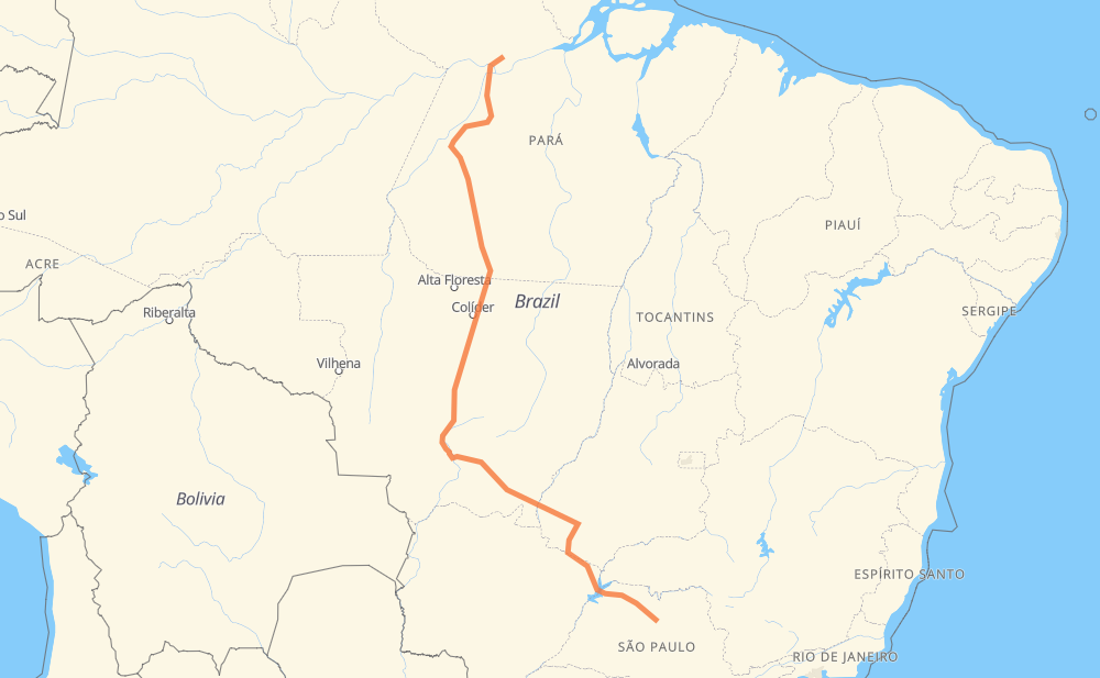
The distance from Goiabal to Catanduva is 3,159 kilometers by road including 261 kilometers on motorways. Road takes approximately 38 hours and 54 minutes and goes through Rurópolis, Castelo dos Sonhos, Sorriso, Mário Raiter, Novo Mundo, Jaciara and Vila Goulart.
| Shortest distance by air | 2,224 km ✈️ |
| Car route length | 3,159 km 🚗 |
| Driving time | 38 h 54 min |
| Fuel amount | 252.7 L |
| Fuel cost | 497.9 CAD |
| Point | Distance | Time | Fuel | |
| -1.84056, -54.35732 | 0 km | 00 min | 0.0 L | |
|
BR-163 392 km, 7 h 42 min
|
||||
| Rurópolis | 392 km | 7 h 42 min | 61.4 L | |
|
BR-163 642 km, 7 h 35 min
|
||||
| Castelo dos Sonhos | 1,034 km | 15 h 17 min | 111.1 L | |
|
BR-163 512 km, 5 h 51 min
|
||||
| Sorriso | 1,546 km | 21 h 08 min | 154.0 L | |
|
BR-163 399 km, 4 h 36 min
|
||||
| Novo Mundo | 1,945 km | 25 h 45 min | 185.8 L | |
|
BR-163 159 km, 1 h 46 min
|
||||
| Jaciara | 2,103 km | 27 h 32 min | 198.6 L | |
|
BR-163 76 km, 53 min
|
||||
| Vila Goulart | 2,180 km | 28 h 25 min | 204.9 L | |
|
BR-364 810 km, 8 h 51 min
|
||||
| Conjunto Habitacional Antônio Marin | 2,989 km | 37 h 17 min | 269.6 L | |
|
SP-320 71 km, 38 min
|
||||
| Jardim Santa Mônica | 3,060 km | 37 h 55 min | 275.4 L | |
|
SP-320 26 km, 14 min
|
||||
| Bairro São Pedro | 3,086 km | 38 h 10 min | 277.3 L | |
|
SP-310 40 km, 23 min
|
||||
| Distrito Industrial II | 3,126 km | 38 h 34 min | 280.4 L | |
|
SP-310 33 km, 19 min
|
||||
| -21.13310, -48.97128 | 3,159 km | 38 h 53 min | 283.4 L | |
Hotels of Catanduva
Frequently Asked Questions
How much does it cost to drive from Goiabal to Catanduva?
Fuel cost: 497.9 CAD
This fuel cost is calculated as: (Route length 3,159 km / 100 km) * (Fuel consumption 8 L/100 km) * (Fuel price 1.97 CAD / L)
You can adjust fuel consumption and fuel price here.
How long is a car ride from Goiabal to Catanduva?
Driving time: 38 h 54 min
This time is calculated for driving at the maximum permitted speed, taking into account traffic rules restrictions.
- 237 km with a maximum speed 110 km/h = 2 h 9 min
- 5 km with a maximum speed 100 km/h = 2 min
- 1,978 km with a maximum speed 90 km/h = 21 h 58 min
- 828 km with a maximum speed 80 km/h = 10 h 20 min
- 1 km with a maximum speed 60 km/h = 1 min
- 34 km with a maximum speed 50 km/h = 40 min
- 6 km with a maximum speed 40 km/h = 8 min
- 71 km with a maximum speed 20 km/h = 3 h 32 min
The calculated driving time does not take into account intermediate stops and traffic jams.
How far is Goiabal to Catanduva by land?
The distance between Goiabal and Catanduva is 3,159 km by road including 261 km on motorways.
Precise satellite coordinates of highways were used for this calculation. The start and finish points are the centers of Goiabal and Catanduva respectively.
How far is Goiabal to Catanduva by plane?
The shortest distance (air line, as the crow flies) between Goiabal and Catanduva is 2,224 km.
This distance is calculated using the Haversine formula as a great-circle distance between two points on the surface of a sphere. The start and finish points are the centers of Goiabal and Catanduva respectively. Actual distance between airports may be different.
How many hours is Goiabal from Catanduva by plane?
Boeing 737 airliner needs 2 h 46 min to cover the distance of 2,224 km at a cruising speed of 800 km/h.
Small plane "Cessna 172" needs 10 h 6 min to flight this distance at average speed of 220 km/h.
This time is approximate and do not take into account takeoff and landing times, airport location and other real world factors.
How long is a helicopter ride from Goiabal to Catanduva?
Fast helicopter "Eurocopter AS350" or "Hughes OH-6 Cayuse" need 9 h 16 min to cover the distance of 2,224 km at a cruising speed of 240 km/h.
Popular "Robinson R44" needs 10 h 35 min to flight this distance at average speed of 210 km/h.
This time is approximate and do not take into account takeoff and landing times, aerodrome location and other real world factors.
What city is halfway between Goiabal and Catanduva?
The halfway point between Goiabal and Catanduva is Sorriso. It is located about 34 km from the exact midpoint by road.
The distance from Sorriso to Goiabal is 1,546 km and driving will take about 21 h 8 min. The road between Sorriso and Catanduva has length 1,613 km and will take approximately 17 h 45 min.
The other cities located close to halfway point:
Where is Goiabal in relation to Catanduva?
Goiabal is located 2,224 km north-west of Catanduva.
Goiabal has geographic coordinates: latitude -1.84056, longitude -54.35732.
Catanduva has geographic coordinates: latitude -21.1331, longitude -48.97128.
Which highway goes from Goiabal to Catanduva?
The route from Goiabal to Catanduva follows BR-163, BR-364, SP-320, GO-184, BR-158, BR-230.
Other minor sections pass along the road:
- BR-070: 82 km
- BR-060: 81 km
- SP-310: 71 km
- PA-254: 39 km
- PA-427: 33 km
- GO-302: 27 km
- MT-407: 16 km
- MT-100: 7 km
- BR-436: 2 km