Distance between Garryowen MT and Lemonweir WI
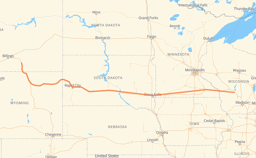
The distance from Garryowen to Lemonweir is 1,622 kilometers by road including 1,615 kilometers on motorways. Road takes approximately 15 hours and goes through Sheridan, Gillette, Spearfish, Rapid City, Box Elder, Mitchell and Sioux Falls.
| Shortest distance by air | 1,387 km ✈️ |
| Car route length | 1,622 km 🚗 |
| Driving time | 15 h |
| Fuel amount | 129.8 L |
| Fuel cost | 254.4 CAD |
| Point | Distance | Time | Fuel | |
| Garryowen | 0 km | 00 min | 0.0 L | |
|
I 90 109 km, 1 h 05 min
|
||||
| Sheridan | 109 km | 1 h 05 min | 7.9 L | |
|
I 90 160 km, 1 h 27 min
|
||||
| Gillette | 270 km | 2 h 32 min | 21.0 L | |
|
I 90 156 km, 1 h 29 min
|
||||
| Spearfish | 425 km | 4 h 01 min | 33.1 L | |
|
I 90 68 km, 37 min
|
||||
| Rapid City | 493 km | 4 h 39 min | 39.2 L | |
|
I 90 18 km, 10 min
|
||||
| Box Elder | 511 km | 4 h 49 min | 40.1 L | |
|
I 90 411 km, 3 h 44 min
|
||||
| Mitchell | 923 km | 8 h 33 min | 72.7 L | |
|
I 90 116 km, 1 h 03 min
|
||||
| Sioux Falls | 1,039 km | 9 h 37 min | 82.8 L | |
|
I 90 11 km, 06 min
|
||||
| Brandon | 1,050 km | 9 h 43 min | 83.7 L | |
|
I 90 572 km, 5 h 16 min
|
||||
| Lemonweir | 1,622 km | 14 h 59 min | 129.6 L | |
Frequently Asked Questions
How much does it cost to drive from Garryowen to Lemonweir?
Fuel cost: 254.4 CAD
This fuel cost is calculated as: (Route length 1,622 km / 100 km) * (Fuel consumption 8 L/100 km) * (Fuel price 1.96 CAD / L)
You can adjust fuel consumption and fuel price here.
How long is a car ride from Garryowen to Lemonweir?
Driving time: 15 h
This time is calculated for driving at the maximum permitted speed, taking into account traffic rules restrictions.
- 1,405 km with a maximum speed 110 km/h = 12 h 46 min
- 41 km with a maximum speed 105 km/h = 23 min
- 117 km with a maximum speed 100 km/h = 1 h 10 min
- 35 km with a maximum speed 97 km/h = 21 min
- 2 km with a maximum speed 90 km/h = 1 min
- 22 km with a maximum speed 80 km/h = 16 min
The calculated driving time does not take into account intermediate stops and traffic jams.
How far is Garryowen to Lemonweir by land?
The distance between Garryowen and Lemonweir is 1,622 km by road including 1,615 km on motorways.
Precise satellite coordinates of highways were used for this calculation. The start and finish points are the centers of Garryowen and Lemonweir respectively.
How far is Garryowen to Lemonweir by plane?
The shortest distance (air line, as the crow flies) between Garryowen and Lemonweir is 1,387 km.
This distance is calculated using the Haversine formula as a great-circle distance between two points on the surface of a sphere. The start and finish points are the centers of Garryowen and Lemonweir respectively. Actual distance between airports may be different.
How many hours is Garryowen from Lemonweir by plane?
Boeing 737 airliner needs 1 h 44 min to cover the distance of 1,387 km at a cruising speed of 800 km/h.
Small plane "Cessna 172" needs 6 h 18 min to flight this distance at average speed of 220 km/h.
This time is approximate and do not take into account takeoff and landing times, airport location and other real world factors.
How long is a helicopter ride from Garryowen to Lemonweir?
Fast helicopter "Eurocopter AS350" or "Hughes OH-6 Cayuse" need 5 h 46 min to cover the distance of 1,387 km at a cruising speed of 240 km/h.
Popular "Robinson R44" needs 6 h 36 min to flight this distance at average speed of 210 km/h.
This time is approximate and do not take into account takeoff and landing times, aerodrome location and other real world factors.
What city is halfway between Garryowen and Lemonweir?
The halfway point between Garryowen and Lemonweir is Oacoma. It is located about 9 km from the exact midpoint by road.
The distance from Oacoma to Garryowen is 820 km and driving will take about 7 h 37 min. The road between Oacoma and Lemonweir has length 802 km and will take approximately 7 h 22 min.
The other cities located close to halfway point:
Where is Garryowen in relation to Lemonweir?
Garryowen is located 1,387 km west of Lemonweir.
Garryowen has geographic coordinates: latitude 45.52679, longitude -107.4166.
Lemonweir has geographic coordinates: latitude 43.78442, longitude -90.01707.
Which highway goes from Garryowen to Lemonweir?
The route from Garryowen to Lemonweir follows I 90, US 14, US 87.
Other minor sections pass along the road:
- SD 79: 50 km
- US 16: 40 km
- I 94: 38 km
- US 83: 31 km
- US 85: 11 km
- SD 63: 11 km
- SD 73: 10 km
- SD 50: 10 km
- SD 34: 9 km
- SD 45: 7 km
- US 61: 7 km
- US 16 Truck: 6 km
- MN 43: 4 km
- US 218: 4 km
- CTH N: 3 km
- SD 37: 2 km
- US 53: 2 km
- US 12: 2 km
- WI 16: 2 km
- WI 82: 1 km