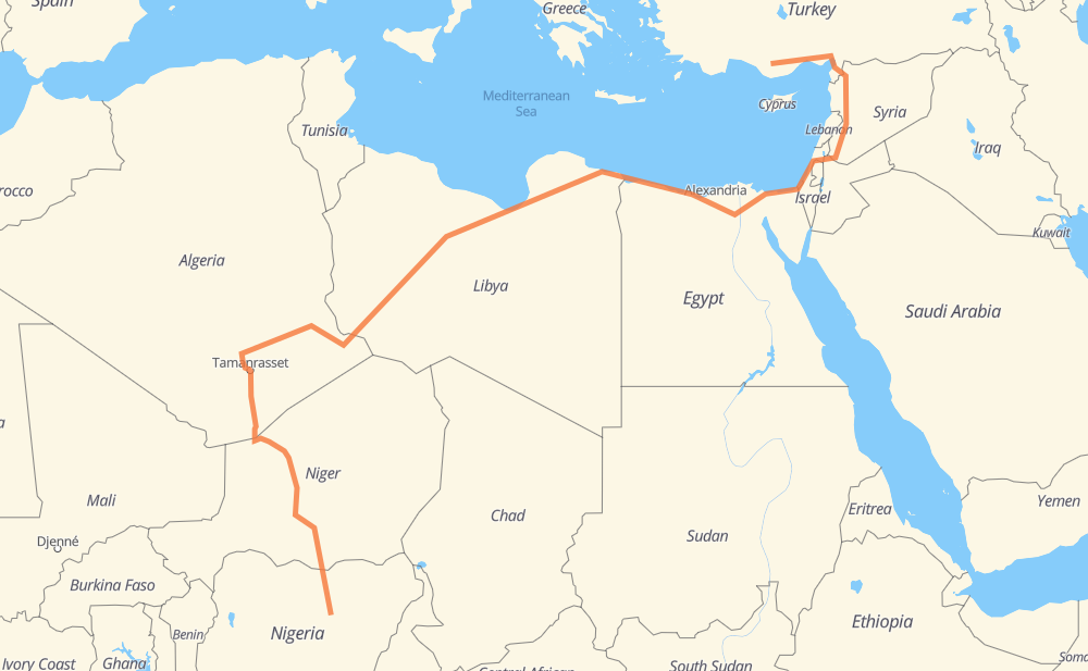
Distance between Güneyyurt and Durum
The distance from Güneyyurt to Durum is 7,099 kilometers by road including 830 kilometers on motorways. Road takes approximately 87 hours and 59 minutes and goes through Idlib, Maarrat al-Nu'man, Homs, Daraa, Irbid, Afula and Rishon LeZion.
| Shortest distance by air | 3,718 km ✈️ |
| Car route length | 7,099 km 🚗 |
| Driving time | 87 h 59 min |
| Fuel amount | 568 L |
| Fuel cost | 1,113.2 CAD |
| Point | Distance | Time | Fuel | |
| Yenimahalle | 0 km | 00 min | 0.0 L | |
|
D340 O-51 554 km, 6 h 22 min
|
||||
| Idlib | 554 km | 6 h 22 min | 43.6 L | |
|
52 km, 35 min
|
||||
| Maarrat al-Nu'man | 606 km | 6 h 58 min | 46.4 L | |
|
M5 108 km, 1 h 10 min
|
||||
| Homs | 714 km | 8 h 09 min | 56.8 L | |
|
M5 273 km, 2 h 38 min
|
||||
| Daraa | 987 km | 10 h 47 min | 78.6 L | |
|
109 25 29 km, 21 min
|
||||
| Irbid | 1,015 km | 11 h 08 min | 80.5 L | |
|
10 71 79 km, 57 min
|
||||
| Afula | 1,095 km | 12 h 05 min | 87.3 L | |
|
65 6 101 km, 1 h 01 min
|
||||
| Rishon LeZion | 1,195 km | 13 h 07 min | 95.2 L | |
|
4 40 km, 25 min
|
||||
| Ashkelon | 1,235 km | 13 h 32 min | 98.6 L | |
|
4 107 km, 1 h 21 min
|
||||
| Al Arish | 1,342 km | 14 h 54 min | 107.1 L | |
|
153 185 km, 2 h 10 min
|
||||
| Al Ismailiya | 1,527 km | 17 h 04 min | 121.1 L | |
|
15 80 km, 54 min
|
||||
| Cairo | 1,607 km | 17 h 58 min | 126.3 L | |
|
15 516 124 km, 1 h 14 min
|
||||
| Sadat City | 1,731 km | 19 h 13 min | 135.1 L | |
|
27 10 477 km, 5 h 13 min
|
||||
| Al Sellum | 2,208 km | 24 h 26 min | 168.2 L | |
|
10 5 631 km, 7 h 12 min
|
||||
| Ajdabiya | 2,839 km | 31 h 38 min | 227.0 L | |
|
14 657 km, 7 h 55 min
|
||||
| Houn | 3,496 km | 39 h 33 min | 278.9 L | |
|
9 538 km, 6 h 34 min
|
||||
| Awbari | 4,035 km | 46 h 08 min | 321.9 L | |
|
379 km, 4 h 42 min
|
||||
| Ghat | 4,414 km | 50 h 50 min | 351.5 L | |
|
RN 1 1,769 km, 23 h 22 min
|
||||
| Arlit | 6,182 km | 74 h 13 min | 494.5 L | |
|
N 25 240 km, 2 h 40 min
|
||||
| Agadez | 6,422 km | 76 h 53 min | 513.6 L | |
|
N 25 N 11 286 km, 3 h 25 min
|
||||
| Tanout | 6,708 km | 80 h 19 min | 536.2 L | |
|
N 11 151 km, 1 h 53 min
|
||||
| Zinder | 6,859 km | 82 h 12 min | 548.6 L | |
|
N 11 81 km, 1 h 00 min
|
||||
| Magaria | 6,940 km | 83 h 12 min | 552.6 L | |
|
N 11 F.244 372 km, 4 h 46 min
|
||||
| Durum | 7,312 km | 87 h 59 min | 580.7 L | |
Frequently Asked Questions
How much does it cost to drive from Güneyyurt to Durum?
Fuel cost: 1,113.2 CAD
This fuel cost is calculated as: (Route length 7,099 km / 100 km) * (Fuel consumption 8 L/100 km) * (Fuel price 1.96 CAD / L)
You can adjust fuel consumption and fuel price here.
How long is a car ride from Güneyyurt to Durum?
Driving time: 87 h 59 min
This time is calculated for driving at the maximum permitted speed, taking into account traffic rules restrictions.
- 552 km with a maximum speed 110 km/h = 5 h 1 min
- 144 km with a maximum speed 100 km/h = 1 h 26 min
- 2,271 km with a maximum speed 90 km/h = 25 h 14 min
- 4,116 km with a maximum speed 80 km/h = 51 h 26 min
- 58 km with a maximum speed 60 km/h = 57 min
- 155 km with a maximum speed 50 km/h = 3 h 6 min
- 15 km with a maximum speed 20 km/h = 45 min
The calculated driving time does not take into account intermediate stops and traffic jams.
How far is Güneyyurt to Durum by land?
The distance between Güneyyurt and Durum is 7,099 km by road including 830 km on motorways.
Precise satellite coordinates of highways were used for this calculation. The start and finish points are the centers of Güneyyurt and Durum respectively.
How far is Güneyyurt to Durum by plane?
The shortest distance (air line, as the crow flies) between Güneyyurt and Durum is 3,718 km.
This distance is calculated using the Haversine formula as a great-circle distance between two points on the surface of a sphere. The start and finish points are the centers of Güneyyurt and Durum respectively. Actual distance between airports may be different.
How many hours is Güneyyurt from Durum by plane?
Boeing 737 airliner needs 4 h 38 min to cover the distance of 3,718 km at a cruising speed of 800 km/h.
Small plane "Cessna 172" needs 16 h 53 min to flight this distance at average speed of 220 km/h.
This time is approximate and do not take into account takeoff and landing times, airport location and other real world factors.
How long is a helicopter ride from Güneyyurt to Durum?
Fast helicopter "Eurocopter AS350" or "Hughes OH-6 Cayuse" need 15 h 29 min to cover the distance of 3,718 km at a cruising speed of 240 km/h.
Popular "Robinson R44" needs 17 h 42 min to flight this distance at average speed of 210 km/h.
This time is approximate and do not take into account takeoff and landing times, aerodrome location and other real world factors.
What city is halfway between Güneyyurt and Durum?
The halfway point between Güneyyurt and Durum is Suknah. It is located about 23 km from the exact midpoint by road.
The distance from Suknah to Güneyyurt is 3,527 km and driving will take about 39 h 54 min. The road between Suknah and Durum has length 3,573 km and will take approximately 48 h 5 min.
The other cities located close to halfway point:
Where is Güneyyurt in relation to Durum?
Güneyyurt is located 3,718 km north-east of Durum.
Güneyyurt has geographic coordinates: latitude 36.68099, longitude 32.80834.
Durum has geographic coordinates: latitude 10.50976, longitude 9.76945.
Which highway goes from Güneyyurt to Durum?
The route from Güneyyurt to Durum follows N 25, N 11, RN 1, 10, M5, 5, RN 55, RN 3A, 9, RN 3, 14, 261, 15.
Other minor sections pass along the road:
- O-51: 99 km
- 2: 93 km
- 27: 85 km
- O-53: 78 km
- 1: 72 km
- D340: 67 km
- 4: 65 km
- D715: 62 km
- D400: 61 km
- O-52: 60 km
- F.244: 49 km
- D827: 47 km
- 6: 47 km
- A237: 43 km
- 65: 37 km
- 71: 30 km
- 516: 25 km
- F.130: 18 km
- D817: 15 km
- 420: 15 km
- 25: 10 km
- 153: 9 km
- 109: 9 km
- 471: 8 km
- M45: 6 km
- F.131: 3 km
- ط و 1: 2 km
- M1: 2 km