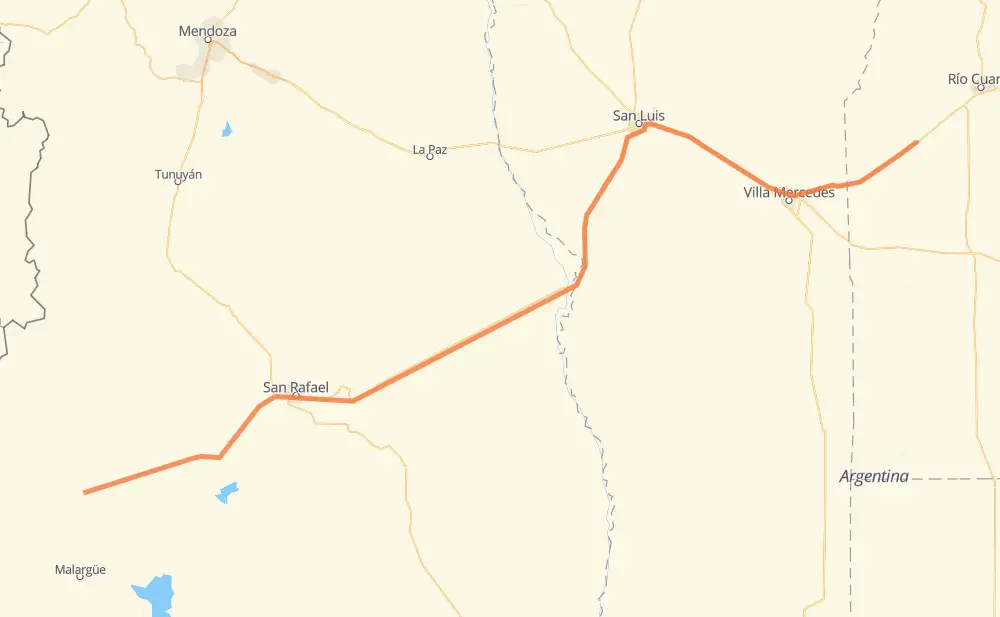
Distance between El Sosneado and Sampacho
The distance from El Sosneado to Sampacho is 580 kilometers by road. Road takes approximately 6 hours and 39 minutes and goes through San Rafael, San Luis, La Llave Nueva, Monte Comán, Beazley, Fraga and Juan Jorba.
| Shortest distance by air | 484 km ✈️ |
| Car route length | 580 km 🚗 |
| Driving time | 6 h 39 min |
| Fuel amount | 46.4 L |
| Fuel cost | 90.9 CAD |
| Point | Distance | Time | Fuel | |
| El Sosneado | 0 km | 00 min | 0.0 L | |
|
RN40 RN144 136 km, 1 h 34 min
|
||||
| San Rafael | 136 km | 1 h 34 min | 10.5 L | |
|
RN146 44 km, 30 min
|
||||
| La Llave Nueva | 181 km | 2 h 04 min | 13.8 L | |
|
RN146 11 km, 07 min
|
||||
| Monte Comán | 191 km | 2 h 12 min | 15.1 L | |
|
RN146 167 km, 1 h 54 min
|
||||
| Beazley | 358 km | 4 h 07 min | 25.0 L | |
|
RN146 52 km, 36 min
|
||||
| San Luis | 410 km | 4 h 43 min | 32.4 L | |
|
RN7 60 km, 40 min
|
||||
| Fraga | 470 km | 5 h 24 min | 36.6 L | |
|
RN7 46 km, 31 min
|
||||
| Juan Jorba | 517 km | 5 h 55 min | 40.9 L | |
|
RN8 31 km, 21 min
|
||||
| Chaján | 548 km | 6 h 17 min | 43.5 L | |
|
RN8 32 km, 21 min
|
||||
| Sampacho | 580 km | 6 h 39 min | 46.3 L | |
Frequently Asked Questions
How much does it cost to drive from El Sosneado to Sampacho?
Fuel cost: 90.9 CAD
This fuel cost is calculated as: (Route length 580 km / 100 km) * (Fuel consumption 8 L/100 km) * (Fuel price 1.96 CAD / L)
You can adjust fuel consumption and fuel price here.
How long is a car ride from El Sosneado to Sampacho?
Driving time: 6 h 39 min
This time is calculated for driving at the maximum permitted speed, taking into account traffic rules restrictions.
- 471 km with a maximum speed 90 km/h = 5 h 14 min
- 96 km with a maximum speed 80 km/h = 1 h 12 min
- 10 km with a maximum speed 60 km/h = 9 min
- 1 km with a maximum speed 50 km/h = 1 min
- 1 km with a maximum speed 40 km/h = 1 min
The calculated driving time does not take into account intermediate stops and traffic jams.
How far is El Sosneado to Sampacho by land?
The distance between El Sosneado and Sampacho is 580 km by road.
Precise satellite coordinates of highways were used for this calculation. The start and finish points are the centers of El Sosneado and Sampacho respectively.
How far is El Sosneado to Sampacho by plane?
The shortest distance (air line, as the crow flies) between El Sosneado and Sampacho is 484 km.
This distance is calculated using the Haversine formula as a great-circle distance between two points on the surface of a sphere. The start and finish points are the centers of El Sosneado and Sampacho respectively. Actual distance between airports may be different.
How many hours is El Sosneado from Sampacho by plane?
Boeing 737 airliner needs 36 min to cover the distance of 484 km at a cruising speed of 800 km/h.
Small plane "Cessna 172" needs 2 h 12 min to flight this distance at average speed of 220 km/h.
This time is approximate and do not take into account takeoff and landing times, airport location and other real world factors.
How long is a helicopter ride from El Sosneado to Sampacho?
Fast helicopter "Eurocopter AS350" or "Hughes OH-6 Cayuse" need 2 h 1 min to cover the distance of 484 km at a cruising speed of 240 km/h.
Popular "Robinson R44" needs 2 h 18 min to flight this distance at average speed of 210 km/h.
This time is approximate and do not take into account takeoff and landing times, aerodrome location and other real world factors.
What city is halfway between El Sosneado and Sampacho?
The halfway point between El Sosneado and Sampacho is Beazley. It is located about 69 km from the exact midpoint by road.
The distance from Beazley to El Sosneado is 358 km and driving will take about 4 h 6 min. The road between Beazley and Sampacho has length 221 km and will take approximately 2 h 32 min.
Where is El Sosneado in relation to Sampacho?
El Sosneado is located 484 km south-west of Sampacho.
El Sosneado has geographic coordinates: latitude -35.07886, longitude -69.56773.
Sampacho has geographic coordinates: latitude -33.38407, longitude -64.72295.
Which highway goes from El Sosneado to Sampacho?
The route from El Sosneado to Sampacho follows RN146, RN144, RN7.
Other minor sections pass along the road:
- RN8: 74 km
- RN40: 10 km
- RN143: 6 km