Distance between El Coyunco and General Cerri
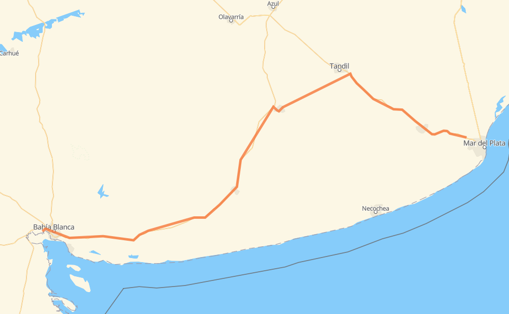
The distance from El Coyunco to General Cerri is 523 kilometers by road. Road takes approximately 6 hours and 3 minutes and goes through Tandil, Bahía Blanca, Benito Juárez, Adolfo Gonzales Chaves, Tres Arroyos, Pago Chico and Grünbein.
| Shortest distance by air | 415 km ✈️ |
| Car route length | 523 km 🚗 |
| Driving time | 6 h 3 min |
| Fuel amount | 41.8 L |
| Fuel cost | 82 CAD |
| Point | Distance | Time | Fuel | |
| El Coyunco | 0 km | 00 min | 0.0 L | |
|
RN226 150 km, 1 h 42 min
|
||||
| Tandil | 150 km | 1 h 42 min | 11.7 L | |
|
RP74 69 km, 46 min
|
||||
| Benito Juárez | 219 km | 2 h 29 min | 17.2 L | |
|
RP86 RN3 73 km, 50 min
|
||||
| Adolfo Gonzales Chaves | 293 km | 3 h 20 min | 21.8 L | |
|
RN3 25 km, 18 min
|
||||
| Tres Arroyos | 318 km | 3 h 38 min | 25.1 L | |
|
RN3 21 km, 15 min
|
||||
| Micaela Cascallares | 339 km | 3 h 54 min | 25.8 L | |
|
RN3 147 km, 1 h 40 min
|
||||
| Pago Chico | 486 km | 5 h 34 min | 38.2 L | |
|
RN3 13 km, 09 min
|
||||
| Grünbein | 499 km | 5 h 44 min | 39.6 L | |
|
RN3 11 km, 09 min
|
||||
| Bahía Blanca | 510 km | 5 h 53 min | 40.2 L | |
|
RN3 13 km, 10 min
|
||||
| General Cerri | 523 km | 6 h 03 min | 41.5 L | |
Frequently Asked Questions
How much does it cost to drive from El Coyunco to General Cerri?
Fuel cost: 82 CAD
This fuel cost is calculated as: (Route length 523 km / 100 km) * (Fuel consumption 8 L/100 km) * (Fuel price 1.96 CAD / L)
You can adjust fuel consumption and fuel price here.
How long is a car ride from El Coyunco to General Cerri?
Driving time: 6 h 3 min
This time is calculated for driving at the maximum permitted speed, taking into account traffic rules restrictions.
- 381 km with a maximum speed 90 km/h = 4 h 13 min
- 129 km with a maximum speed 80 km/h = 1 h 36 min
- 6 km with a maximum speed 65 km/h = 5 min
- 7 km with a maximum speed 60 km/h = 7 min
- 1 km with a maximum speed 40 km/h = 1 min
The calculated driving time does not take into account intermediate stops and traffic jams.
How far is El Coyunco to General Cerri by land?
The distance between El Coyunco and General Cerri is 523 km by road.
Precise satellite coordinates of highways were used for this calculation. The start and finish points are the centers of El Coyunco and General Cerri respectively.
How far is El Coyunco to General Cerri by plane?
The shortest distance (air line, as the crow flies) between El Coyunco and General Cerri is 415 km.
This distance is calculated using the Haversine formula as a great-circle distance between two points on the surface of a sphere. The start and finish points are the centers of El Coyunco and General Cerri respectively. Actual distance between airports may be different.
How many hours is El Coyunco from General Cerri by plane?
Boeing 737 airliner needs 31 min to cover the distance of 415 km at a cruising speed of 800 km/h.
Small plane "Cessna 172" needs 1 h 53 min to flight this distance at average speed of 220 km/h.
This time is approximate and do not take into account takeoff and landing times, airport location and other real world factors.
How long is a helicopter ride from El Coyunco to General Cerri?
Fast helicopter "Eurocopter AS350" or "Hughes OH-6 Cayuse" need 1 h 43 min to cover the distance of 415 km at a cruising speed of 240 km/h.
Popular "Robinson R44" needs 1 h 58 min to flight this distance at average speed of 210 km/h.
This time is approximate and do not take into account takeoff and landing times, aerodrome location and other real world factors.
What city is halfway between El Coyunco and General Cerri?
The halfway point between El Coyunco and General Cerri is Adolfo Gonzales Chaves. It is located about 31 km from the exact midpoint by road.
The distance from Adolfo Gonzales Chaves to El Coyunco is 293 km and driving will take about 3 h 20 min. The road between Adolfo Gonzales Chaves and General Cerri has length 230 km and will take approximately 2 h 43 min.
The other cities located close to halfway point:
Where is El Coyunco in relation to General Cerri?
El Coyunco is located 415 km east of General Cerri.
El Coyunco has geographic coordinates: latitude -37.9135, longitude -57.74316.
General Cerri has geographic coordinates: latitude -38.71933, longitude -62.39125.
Which highway goes from El Coyunco to General Cerri?
The route from El Coyunco to General Cerri follows RN3, RN226.
Other minor sections pass along the road:
- RP74: 79 km
- RP85: 7 km
- RP86: 5 km
- Ex RN3: 3 km