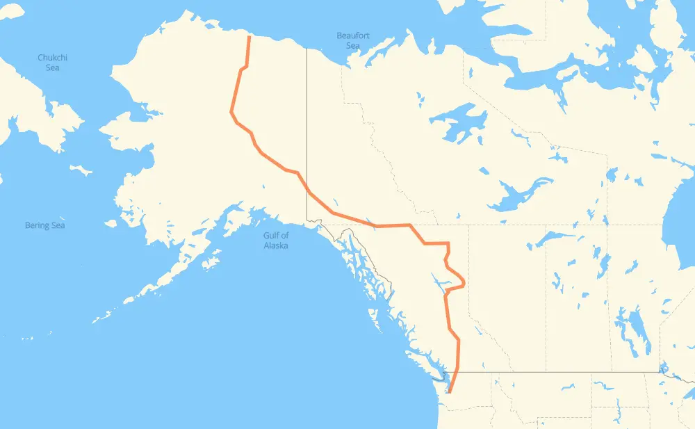
Distance between Deadhorse AK and Lakewood WA
The distance from Deadhorse to Lakewood is 4,467 kilometers by road including 297 kilometers on motorways. Road takes approximately 51 hours and 40 minutes and goes through Whitehorse, Fort St. John, Prince George, Quesnel, Williams Lake, Chilliwack and Abbotsford.
| Shortest distance by air | 2,916 km ✈️ |
| Car route length | 4,467 km 🚗 |
| Driving time | 51 h 40 min |
| Fuel amount | 357.4 L |
| Fuel cost | 707.6 CAD |
| Point | Distance | Time | Fuel | |
| Deadhorse | 0 km | 00 min | 0.0 L | |
|
AK 11 1,743 km, 20 h 27 min
|
||||
| Whitehorse | 1,743 km | 20 h 27 min | 138.9 L | |
|
1 97 1,328 km, 15 h 14 min
|
||||
| Fort St. John | 3,071 km | 35 h 41 min | 245.2 L | |
|
97 433 km, 5 h 06 min
|
||||
| Prince George | 3,503 km | 40 h 47 min | 279.3 L | |
|
97 125 km, 1 h 27 min
|
||||
| Quesnel | 3,628 km | 42 h 15 min | 289.7 L | |
|
97 116 km, 1 h 20 min
|
||||
| Williams Lake | 3,744 km | 43 h 36 min | 298.6 L | |
|
97 1 445 km, 5 h 05 min
|
||||
| Chilliwack | 4,189 km | 48 h 41 min | 333.9 L | |
|
1 25 km, 15 min
|
||||
| Abbotsford | 4,214 km | 48 h 57 min | 336.3 L | |
|
1 WA 9 53 km, 39 min
|
||||
| Bellingham | 4,267 km | 49 h 37 min | 340.5 L | |
|
I 5 93 km, 54 min
|
||||
| Everett | 4,360 km | 50 h 32 min | 348.1 L | |
|
I 5 43 km, 26 min
|
||||
| Seattle | 4,403 km | 50 h 59 min | 351.1 L | |
|
I 5 55 km, 34 min
|
||||
| Tacoma | 4,458 km | 51 h 33 min | 356.2 L | |
|
I 5 9 km, 06 min
|
||||
| Lakewood | 4,468 km | 51 h 40 min | 357.2 L | |
Hotels of Lakewood
Frequently Asked Questions
How much does it cost to drive from Deadhorse to Lakewood?
Fuel cost: 707.6 CAD
This fuel cost is calculated as: (Route length 4,467 km / 100 km) * (Fuel consumption 8 L/100 km) * (Fuel price 1.98 CAD / L)
You can adjust fuel consumption and fuel price here.
How long is a car ride from Deadhorse to Lakewood?
Driving time: 51 h 40 min
This time is calculated for driving at the maximum permitted speed, taking into account traffic rules restrictions.
- 54 km with a maximum speed 110 km/h = 29 min
- 77 km with a maximum speed 100 km/h = 46 min
- 158 km with a maximum speed 97 km/h = 1 h 38 min
- 2,637 km with a maximum speed 90 km/h = 29 h 18 min
- 70 km with a maximum speed 89 km/h = 47 min
- 607 km with a maximum speed 80 km/h = 7 h 32 min
- 775 km with a maximum speed 80 km/h = 9 h 41 min
- 8 km with a maximum speed 72 km/h = 6 min
- 36 km with a maximum speed 70 km/h = 31 min
- 2 km with a maximum speed 64 km/h = 1 min
- 17 km with a maximum speed 60 km/h = 16 min
- 6 km with a maximum speed 56 km/h = 6 min
- 17 km with a maximum speed 50 km/h = 20 min
- 1 km with a maximum speed 40 km/h = 1 min
The calculated driving time does not take into account intermediate stops and traffic jams.
How far is Deadhorse to Lakewood by land?
The distance between Deadhorse and Lakewood is 4,467 km by road including 297 km on motorways.
Precise satellite coordinates of highways were used for this calculation. The start and finish points are the centers of Deadhorse and Lakewood respectively.
How far is Deadhorse to Lakewood by plane?
The shortest distance (air line, as the crow flies) between Deadhorse and Lakewood is 2,916 km.
This distance is calculated using the Haversine formula as a great-circle distance between two points on the surface of a sphere. The start and finish points are the centers of Deadhorse and Lakewood respectively. Actual distance between airports may be different.
How many hours is Deadhorse from Lakewood by plane?
Boeing 737 airliner needs 3 h 38 min to cover the distance of 2,916 km at a cruising speed of 800 km/h.
Small plane "Cessna 172" needs 13 h 15 min to flight this distance at average speed of 220 km/h.
This time is approximate and do not take into account takeoff and landing times, airport location and other real world factors.
How long is a helicopter ride from Deadhorse to Lakewood?
Fast helicopter "Eurocopter AS350" or "Hughes OH-6 Cayuse" need 12 h 9 min to cover the distance of 2,916 km at a cruising speed of 240 km/h.
Popular "Robinson R44" needs 13 h 53 min to flight this distance at average speed of 210 km/h.
This time is approximate and do not take into account takeoff and landing times, aerodrome location and other real world factors.
What city is halfway between Deadhorse and Lakewood?
The halfway point between Deadhorse and Lakewood is Lower Post. It is located about 29 km from the exact midpoint by road.
The distance from Lower Post to Deadhorse is 2,205 km and driving will take about 25 h 46 min. The road between Lower Post and Lakewood has length 2,263 km and will take approximately 25 h 54 min.
The other cities located close to halfway point:
Where is Deadhorse in relation to Lakewood?
Deadhorse is located 2,916 km north-west of Lakewood.
Deadhorse has geographic coordinates: latitude 70.2007, longitude -148.45982.
Lakewood has geographic coordinates: latitude 47.17176, longitude -122.51846.
Which highway goes from Deadhorse to Lakewood?
The route from Deadhorse to Lakewood follows 97, 1, AK 11, AK 2, I 5.
Other minor sections pass along the road:
- 2: 75 km
- WA 9: 12 km
- I 5 Express: 12 km
- WA 542: 8 km
- WA 544: 6 km
- 97C: 4 km
- 11: 4 km
- 29: 3 km