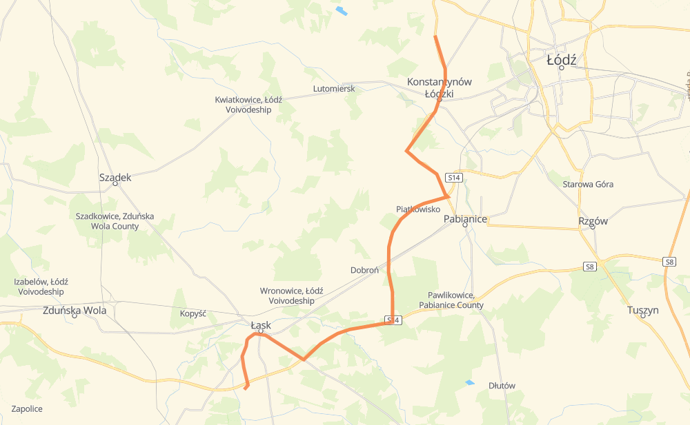
Distance between Dąbrówka and Rąbień
The distance from Dąbrówka to Rąbień is 43 kilometers by road. Road takes approximately 35 minutes and goes through Lask, Konstantynów Łódzki, Aleksandrów Łódzki, Łopatki-Cegielnia, Gorczyn, Łopatki and Teodory-Osiedle.
| Shortest distance by air | 30 km ✈️ |
| Car route length | 43 km 🚗 |
| Driving time | 35 min |
| Fuel amount | 3.5 L |
| Fuel cost | 6.8 CAD |
| Point | Distance | Time | Fuel | |
| Dąbrówka | 0 km | 00 min | 0.0 L | |
|
3 km, 03 min
|
||||
| Łopatki-Cegielnia | 3 km | 03 min | 0.1 L | |
|
481 3 km, 03 min
|
||||
| Lask | 6 km | 06 min | 0.3 L | |
|
473 3 km, 02 min
|
||||
| Teodory-Osiedle | 9 km | 08 min | 0.6 L | |
|
473 S14 18 km, 12 min
|
||||
| Piątkowisko | 26 km | 21 min | 2.0 L | |
|
S14 71 3 km, 01 min
|
||||
| Szynkielew | 29 km | 22 min | 2.3 L | |
|
71 1 km, 00 min
|
||||
| Górka Pabianicka | 30 km | 23 min | 2.3 L | |
|
71 2 km, 01 min
|
||||
| Świątniki | 32 km | 25 min | 2.5 L | |
|
71 5 km, 04 min
|
||||
| Konstantynów Łódzki | 37 km | 29 min | 2.7 L | |
|
71 6 km, 05 min
|
||||
| Rąbień | 43 km | 35 min | 3.4 L | |
Frequently Asked Questions
How much does it cost to drive from Dąbrówka to Rąbień?
Fuel cost: 6.8 CAD
This fuel cost is calculated as: (Route length 43 km / 100 km) * (Fuel consumption 8 L/100 km) * (Fuel price 1.97 CAD / L)
You can adjust fuel consumption and fuel price here.
How long is a car ride from Dąbrówka to Rąbień?
Driving time: 35 min
This time is calculated for driving at the maximum permitted speed, taking into account traffic rules restrictions.
- 19 km with a maximum speed 90 km/h = 12 min
- 12 km with a maximum speed 80 km/h = 8 min
- 2 km with a maximum speed 70 km/h = 1 min
- 9 km with a maximum speed 50 km/h = 11 min
The calculated driving time does not take into account intermediate stops and traffic jams.
How far is Dąbrówka to Rąbień by land?
The distance between Dąbrówka and Rąbień is 43 km by road.
Precise satellite coordinates of highways were used for this calculation. The start and finish points are the centers of Dąbrówka and Rąbień respectively.
What city is halfway between Dąbrówka and Rąbień?
Where is Dąbrówka in relation to Rąbień?
Dąbrówka is located 30 km south-west of Rąbień.
Dąbrówka has geographic coordinates: latitude 51.55358, longitude 19.11565.
Rąbień has geographic coordinates: latitude 51.79028, longitude 19.32132.
Which highway goes from Dąbrówka to Rąbień?
The route from Dąbrówka to Rąbień follows 71.
Other minor sections pass along the road:
- S14: 12 km
- S8: 7 km
- 12: 7 km
- 473: 3 km
- 481: 2 km