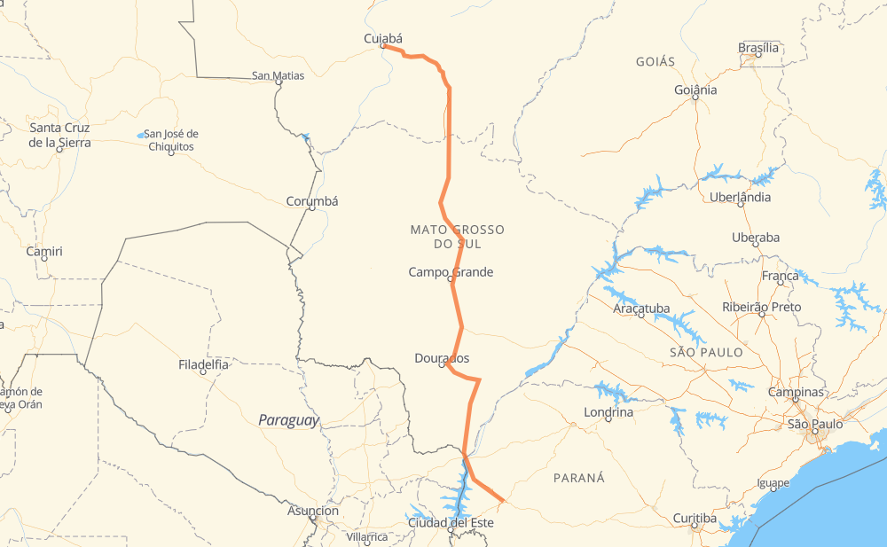
Distance between Cuiabá and Cascavel
The distance from Cuiabá to Cascavel is 1,348 kilometers by road including 186 kilometers on motorways. Road takes approximately 15 hours and 20 minutes and goes through Jaciara, Vila Goulart, Coxim, Rio Verde de Mato Grosso, São Gabriel do Oeste, Nova Lima and Moradia do Sol.
| Shortest distance by air | 1,077 km ✈️ |
| Car route length | 1,348 km 🚗 |
| Driving time | 15 h 20 min |
| Fuel amount | 107.8 L |
| Fuel cost | 211.4 CAD |
| Point | Distance | Time | Fuel | |
| Cuiabá | 0 km | 00 min | 0.0 L | |
|
BR-070 BR-364 144 km, 1 h 37 min
|
||||
| Jaciara | 144 km | 1 h 37 min | 11.1 L | |
|
BR-163 79 km, 55 min
|
||||
| Vila Goulart | 223 km | 2 h 32 min | 17.4 L | |
|
BR-163 215 km, 2 h 20 min
|
||||
| Coxim | 438 km | 4 h 52 min | 33.4 L | |
|
BR-163 68 km, 47 min
|
||||
| Rio Verde de Mato Grosso | 506 km | 5 h 40 min | 39.6 L | |
|
BR-163 66 km, 45 min
|
||||
| São Gabriel do Oeste | 571 km | 6 h 25 min | 45.3 L | |
|
BR-163 125 km, 1 h 27 min
|
||||
| Nova Lima | 696 km | 7 h 53 min | 55.5 L | |
|
BR-163 24 km, 18 min
|
||||
| Moradia do Sol | 721 km | 8 h 11 min | 57.2 L | |
|
BR-163 19 km, 14 min
|
||||
| Chácara das Mansões | 740 km | 8 h 26 min | 58.1 L | |
|
BR-163 612 km, 6 h 54 min
|
||||
| Cascavel | 1,352 km | 15 h 20 min | 107.5 L | |
Hotels of Cascavel
Frequently Asked Questions
How much does it cost to drive from Cuiabá to Cascavel?
Fuel cost: 211.4 CAD
This fuel cost is calculated as: (Route length 1,348 km / 100 km) * (Fuel consumption 8 L/100 km) * (Fuel price 1.96 CAD / L)
You can adjust fuel consumption and fuel price here.
How long is a car ride from Cuiabá to Cascavel?
Driving time: 15 h 20 min
This time is calculated for driving at the maximum permitted speed, taking into account traffic rules restrictions.
- 62 km with a maximum speed 110 km/h = 33 min
- 100 km with a maximum speed 100 km/h = 1 h
- 902 km with a maximum speed 90 km/h = 10 h 1 min
- 266 km with a maximum speed 80 km/h = 3 h 19 min
- 13 km with a maximum speed 60 km/h = 12 min
- 9 km with a maximum speed 40 km/h = 12 min
The calculated driving time does not take into account intermediate stops and traffic jams.
How far is Cuiabá to Cascavel by land?
The distance between Cuiabá and Cascavel is 1,348 km by road including 186 km on motorways.
Precise satellite coordinates of highways were used for this calculation. The start and finish points are the centers of Cuiabá and Cascavel respectively.
How far is Cuiabá to Cascavel by plane?
The shortest distance (air line, as the crow flies) between Cuiabá and Cascavel is 1,077 km.
This distance is calculated using the Haversine formula as a great-circle distance between two points on the surface of a sphere. The start and finish points are the centers of Cuiabá and Cascavel respectively. Actual distance between airports may be different.
How many hours is Cuiabá from Cascavel by plane?
Boeing 737 airliner needs 1 h 20 min to cover the distance of 1,077 km at a cruising speed of 800 km/h.
Small plane "Cessna 172" needs 4 h 53 min to flight this distance at average speed of 220 km/h.
This time is approximate and do not take into account takeoff and landing times, airport location and other real world factors.
How long is a helicopter ride from Cuiabá to Cascavel?
Fast helicopter "Eurocopter AS350" or "Hughes OH-6 Cayuse" need 4 h 29 min to cover the distance of 1,077 km at a cruising speed of 240 km/h.
Popular "Robinson R44" needs 5 h 7 min to flight this distance at average speed of 210 km/h.
This time is approximate and do not take into account takeoff and landing times, aerodrome location and other real world factors.
What city is halfway between Cuiabá and Cascavel?
The halfway point between Cuiabá and Cascavel is Nova Lima. It is located about 22 km from the exact midpoint by road.
The distance from Nova Lima to Cuiabá is 696 km and driving will take about 7 h 53 min. The road between Nova Lima and Cascavel has length 652 km and will take approximately 7 h 27 min.
The other cities located close to halfway point:
Where is Cuiabá in relation to Cascavel?
Cuiabá is located 1,077 km north-west of Cascavel.
Cuiabá has geographic coordinates: latitude -15.59867, longitude -56.09913.
Cascavel has geographic coordinates: latitude -24.9555, longitude -53.45605.
Which highway goes from Cuiabá to Cascavel?
The route from Cuiabá to Cascavel follows BR-163, BR-364, BR-060.
Other minor sections pass along the road:
- BR-070: 81 km
- BR-467: 76 km
- MS-141: 75 km
- BR-376: 59 km
- BR-267: 36 km
- MS-475: 30 km
- BR-262: 15 km
- BR-487: 14 km
- MS-147: 5 km
- PR-182: 5 km
- PR-317: 5 km