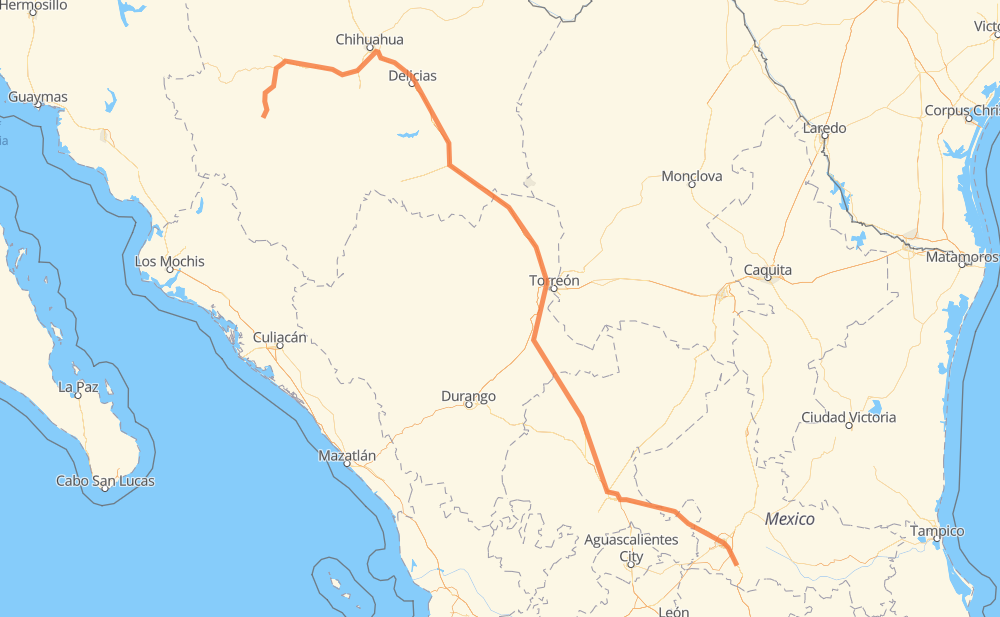
Distance between Creel and El Toro
The distance from Creel to El Toro is 1,317 kilometers by road including 478 kilometers on motorways. Road takes approximately 14 hours and 29 minutes and goes through Cuauhtémoc, Delicias, Camargo, Jiménez, Fresnillo, Guadalupe and San Luis Potosi.
| Shortest distance by air | 953 km ✈️ |
| Car route length | 1,317 km 🚗 |
| Driving time | 14 h 29 min |
| Fuel amount | 105.3 L |
| Fuel cost | 206.4 CAD |
| Toll roads cost | 803 + ? MXN |
| Point | Distance | Time | Fuel | |
| Creel | 0 km | 00 min | 0.0 L | |
|
CHIH 25 37 km, 31 min
|
||||
| San Juanito | 37 km | 31 min | 2.2 L | |
|
CHIH 25 91 km, 1 h 06 min
|
||||
| Páramo de Morelos | 128 km | 1 h 38 min | 9.3 L | |
|
MEX 16 27 km, 18 min
|
||||
| Cuauhtémoc | 156 km | 1 h 57 min | 11.9 L | |
|
MEX 16 183 km, 2 h 06 min
|
||||
| Delicias | 339 km | 4 h 03 min | 26.7 L | |
|
MEX 45 MEX 45D 69 km, 40 min
|
||||
| Camargo | 408 km | 4 h 43 min | 32.2 L | |
|
CHIH 187 MEX 45D 45 km, 28 min
|
||||
| Jiménez | 453 km | 5 h 12 min | 33.6 L | |
|
MEX 45D MEX 49D 576 km, 6 h 01 min
|
||||
| Fresnillo | 1,029 km | 11 h 13 min | 81.5 L | |
|
MEX 45D MEX 49 245 km, 2 h 44 min
|
||||
| San Luis Potosi | 1,274 km | 13 h 58 min | 101.4 L | |
|
MEX 57 42 km, 30 min
|
||||
| El Toro | 1,317 km | 14 h 29 min | 105.3 L | |
Frequently Asked Questions
How many toll booths are there from Creel to El Toro?
There are 12 toll booths between Creel and El Toro: Cuauhtémoc, Saucillo, Camargo, Jimenez, Savalza, León Guzmán, Ceballos, Bermejillo, Cuencame, Morfín Chávez, Calera and Veta Grande.
How much does the toll booths cost from Creel to El Toro?
Toll roads cost: Cuauhtémoc (110 MXN) + Saucillo (71 MXN) + Camargo (71 MXN) + Jimenez (97 MXN) + Savalza (71 MXN) + Ceballos (145 MXN) + Bermejillo (127 MXN) + León Guzmán (?) + Cuencame (?) + Morfín Chávez (40 MXN) + Calera (23 MXN) + Veta Grande (48 MXN) = 803 + ? MXN
How much does it cost to drive from Creel to El Toro?
Fuel cost: 206.4 CAD
This fuel cost is calculated as: (Route length 1,317 km / 100 km) * (Fuel consumption 8 L/100 km) * (Fuel price 1.96 CAD / L)
You can adjust fuel consumption and fuel price here.
Toll roads cost: 803 + ? MXN
How long is a car ride from Creel to El Toro?
Driving time: 14 h 29 min
This time is calculated for driving at the maximum permitted speed, taking into account traffic rules restrictions.
- 167 km with a maximum speed 110 km/h = 1 h 31 min
- 268 km with a maximum speed 100 km/h = 2 h 40 min
- 651 km with a maximum speed 90 km/h = 7 h 14 min
- 204 km with a maximum speed 80 km/h = 2 h 32 min
- 17 km with a maximum speed 60 km/h = 16 min
- 3 km with a maximum speed 50 km/h = 3 min
- 6 km with a maximum speed 40 km/h = 9 min
- 1 km with a maximum speed 30 km/h = 1 min
The calculated driving time does not take into account intermediate stops and traffic jams.
How far is Creel to El Toro by land?
The distance between Creel and El Toro is 1,317 km by road including 478 km on motorways.
Precise satellite coordinates of highways were used for this calculation. The start and finish points are the centers of Creel and El Toro respectively.
How far is Creel to El Toro by plane?
The shortest distance (air line, as the crow flies) between Creel and El Toro is 953 km.
This distance is calculated using the Haversine formula as a great-circle distance between two points on the surface of a sphere. The start and finish points are the centers of Creel and El Toro respectively. Actual distance between airports may be different.
How many hours is Creel from El Toro by plane?
Boeing 737 airliner needs 1 h 11 min to cover the distance of 953 km at a cruising speed of 800 km/h.
Small plane "Cessna 172" needs 4 h 19 min to flight this distance at average speed of 220 km/h.
This time is approximate and do not take into account takeoff and landing times, airport location and other real world factors.
How long is a helicopter ride from Creel to El Toro?
Fast helicopter "Eurocopter AS350" or "Hughes OH-6 Cayuse" need 3 h 58 min to cover the distance of 953 km at a cruising speed of 240 km/h.
Popular "Robinson R44" needs 4 h 32 min to flight this distance at average speed of 210 km/h.
This time is approximate and do not take into account takeoff and landing times, aerodrome location and other real world factors.
What city is halfway between Creel and El Toro?
Where is Creel in relation to El Toro?
Creel is located 953 km north-west of El Toro.
Creel has geographic coordinates: latitude 27.75302, longitude -107.63435.
El Toro has geographic coordinates: latitude 21.86619, longitude -100.76414.
Which highway goes from Creel to El Toro?
The route from Creel to El Toro follows MEX 49, MEX 49D, MEX 45D, MEX 16, MEX 45.
Other minor sections pass along the road:
- CHIH 25: 91 km
- MEX 40D: 85 km
- MEX 57: 41 km
- MEX 40: 9 km
- CHIH 187: 6 km
- MEX 40D:MEX 49D: 3 km
- MEX 80: 2 km
- MEX 54: 1 km
- CHIH 69: 1 km