Distance between Compton QC and Los Angeles CA
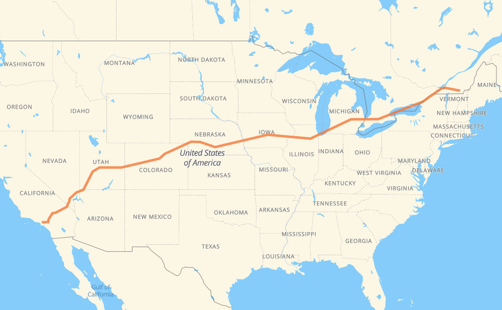
The distance from Compton to Los Angeles is 4,734 kilometers by road including 4,699 kilometers on motorways. Road takes approximately 45 hours and 4 minutes and goes through Montreal, Cornwall, Brockville, Kingston, Belleville, Oshawa and Ajax.
| Shortest distance by air | 4,103 km ✈️ |
| Car route length | 4,734 km 🚗 |
| Driving time | 45 h 4 min |
| Fuel amount | 378.7 L |
| Fuel cost | 719.6 CAD |
| Point | Distance | Time | Fuel | |
| Compton | 0 km | 00 min | 0.0 L | |
|
147 10 159 km, 1 h 46 min
|
||||
| Montreal | 159 km | 1 h 46 min | 12.0 L | |
|
20 103 km, 1 h 05 min
|
||||
| Cornwall | 262 km | 2 h 52 min | 20.6 L | |
|
401 92 km, 55 min
|
||||
| Brockville | 354 km | 3 h 47 min | 27.8 L | |
|
401 79 km, 47 min
|
||||
| Kingston | 432 km | 4 h 34 min | 33.1 L | |
|
401 77 km, 45 min
|
||||
| Belleville | 509 km | 5 h 20 min | 39.8 L | |
|
401 126 km, 1 h 15 min
|
||||
| Oshawa | 635 km | 6 h 36 min | 50.4 L | |
|
401 15 km, 08 min
|
||||
| Ajax | 649 km | 6 h 44 min | 51.7 L | |
|
401 32 km, 19 min
|
||||
| Toronto | 681 km | 7 h 04 min | 52.8 L | |
|
401 31 km, 18 min
|
||||
| Mississauga | 712 km | 7 h 22 min | 56.2 L | |
|
401 66 km, 39 min
|
||||
| Kitchener | 778 km | 8 h 02 min | 61.9 L | |
|
401 42 km, 25 min
|
||||
| Woodstock | 820 km | 8 h 27 min | 65.2 L | |
|
401 402 140 km, 1 h 19 min
|
||||
| Sarnia | 960 km | 9 h 46 min | 76.1 L | |
|
402 I 69 122 km, 1 h 12 min
|
||||
| Flint | 1,082 km | 10 h 59 min | 86.2 L | |
|
I 69 99 km, 53 min
|
||||
| Lansing | 1,181 km | 11 h 53 min | 94.3 L | |
|
I 69 102 km, 55 min
|
||||
| Kalamazoo | 1,282 km | 12 h 49 min | 102.4 L | |
|
I 94 249 km, 2 h 23 min
|
||||
| Joliet | 1,531 km | 15 h 12 min | 122.2 L | |
|
I 80 95 km, 52 min
|
||||
| Peru | 1,627 km | 16 h 05 min | 129.9 L | |
|
I 80 138 km, 1 h 15 min
|
||||
| Davenport | 1,765 km | 17 h 21 min | 140.5 L | |
|
I 280 I 80 79 km, 43 min
|
||||
| Iowa City | 1,844 km | 18 h 05 min | 147.2 L | |
|
I 80 403 km, 3 h 43 min
|
||||
| Omaha | 2,247 km | 21 h 48 min | 179.0 L | |
|
I 80 78 km, 43 min
|
||||
| Lincoln | 2,324 km | 22 h 32 min | 185.3 L | |
|
I 80 371 km, 3 h 22 min
|
||||
| North Platte | 2,695 km | 25 h 55 min | 214.1 L | |
|
I 80 I 76 407 km, 3 h 42 min
|
||||
| Denver | 3,102 km | 29 h 37 min | 248.1 L | |
|
I 76 I 70 153 km, 1 h 32 min
|
||||
| Vail | 3,255 km | 31 h 10 min | 260.2 L | |
|
I 70 862 km, 8 h 07 min
|
||||
| St. George | 4,117 km | 39 h 17 min | 328.7 L | |
|
I 15 172 km, 1 h 36 min
|
||||
| North Las Vegas | 4,289 km | 40 h 54 min | 342.2 L | |
|
I 15 14 km, 07 min
|
||||
| Las Vegas | 4,303 km | 41 h 02 min | 344.0 L | |
|
I 15 304 km, 2 h 46 min
|
||||
| Victorville | 4,607 km | 43 h 48 min | 367.5 L | |
|
I 15 45 km, 24 min
|
||||
| Fontana | 4,651 km | 44 h 13 min | 372.1 L | |
|
I 15 8 km, 04 min
|
||||
| Rancho Cucamonga | 4,659 km | 44 h 17 min | 372.1 L | |
|
I 15 15 km, 08 min
|
||||
| Ontario | 4,675 km | 44 h 26 min | 373.4 L | |
|
I 10 15 km, 08 min
|
||||
| Pomona | 4,689 km | 44 h 34 min | 374.8 L | |
|
I 10 13 km, 07 min
|
||||
| West Covina | 4,703 km | 44 h 42 min | 375.8 L | |
|
I 10 12 km, 06 min
|
||||
| El Monte | 4,714 km | 44 h 49 min | 377.0 L | |
|
I 10 I 10S 5 km, 03 min
|
||||
| Rosemead | 4,720 km | 44 h 52 min | 377.5 L | |
|
I 10S 2 km, 01 min
|
||||
| San Gabriel | 4,721 km | 44 h 53 min | 377.7 L | |
|
I 10S 3 km, 02 min
|
||||
| Alhambra | 4,725 km | 44 h 55 min | 377.7 L | |
|
I 10S 11 km, 08 min
|
||||
| Los Angeles | 4,735 km | 45 h 03 min | 378.2 L | |
Hotels of Los Angeles
Frequently Asked Questions
How much does it cost to drive from Compton to Los Angeles?
Fuel cost: 719.6 CAD
This fuel cost is calculated as: (Route length 4,734 km / 100 km) * (Fuel consumption 8 L/100 km) * (Fuel price 1.9 CAD / L)
You can adjust fuel consumption and fuel price here.
How long is a car ride from Compton to Los Angeles?
Driving time: 45 h 4 min
This time is calculated for driving at the maximum permitted speed, taking into account traffic rules restrictions.
- 3,059 km with a maximum speed 110 km/h = 27 h 48 min
- 370 km with a maximum speed 105 km/h = 3 h 32 min
- 1,021 km with a maximum speed 100 km/h = 10 h 12 min
- 33 km with a maximum speed 97 km/h = 20 min
- 10 km with a maximum speed 90 km/h = 6 min
- 86 km with a maximum speed 89 km/h = 58 min
- 9 km with a maximum speed 80 km/h = 6 min
- 115 km with a maximum speed 80 km/h = 1 h 25 min
- 16 km with a maximum speed 70 km/h = 13 min
- 1 km with a maximum speed 65 km/h = 1 min
- 15 km with a maximum speed 50 km/h = 17 min
The calculated driving time does not take into account intermediate stops and traffic jams.
How far is Compton to Los Angeles by land?
The distance between Compton and Los Angeles is 4,734 km by road including 4,699 km on motorways.
Precise satellite coordinates of highways were used for this calculation. The start and finish points are the centers of Compton and Los Angeles respectively.
How far is Compton to Los Angeles by plane?
The shortest distance (air line, as the crow flies) between Compton and Los Angeles is 4,103 km.
This distance is calculated using the Haversine formula as a great-circle distance between two points on the surface of a sphere. The start and finish points are the centers of Compton and Los Angeles respectively. Actual distance between airports may be different.
How many hours is Compton from Los Angeles by plane?
Boeing 737 airliner needs 5 h 7 min to cover the distance of 4,103 km at a cruising speed of 800 km/h.
Small plane "Cessna 172" needs 18 h 39 min to flight this distance at average speed of 220 km/h.
This time is approximate and do not take into account takeoff and landing times, airport location and other real world factors.
How long is a helicopter ride from Compton to Los Angeles?
Fast helicopter "Eurocopter AS350" or "Hughes OH-6 Cayuse" need 17 h 5 min to cover the distance of 4,103 km at a cruising speed of 240 km/h.
Popular "Robinson R44" needs 19 h 32 min to flight this distance at average speed of 210 km/h.
This time is approximate and do not take into account takeoff and landing times, aerodrome location and other real world factors.
What city is halfway between Compton and Los Angeles?
The halfway point between Compton and Los Angeles is York. It is located about 28 km from the exact midpoint by road.
The distance from York to Compton is 2,395 km and driving will take about 23 h 9 min. The road between York and Los Angeles has length 2,340 km and will take approximately 21 h 54 min.
The other cities located close to halfway point:
Where is Compton in relation to Los Angeles?
Compton is located 4,103 km east of Los Angeles.
Compton has geographic coordinates: latitude 45.24323, longitude -71.82793.
Los Angeles has geographic coordinates: latitude 34.05494, longitude -118.24448.
Which highway goes from Compton to Los Angeles?
The route from Compton to Los Angeles follows I 80, I 70, I 15, US 6, 401, I 76, US 50, I 69, I 94, 10, 402.
Other minor sections pass along the road:
- 20: 78 km
- US 89: 52 km
- I 10: 48 km
- I 280: 44 km
- US 191: 38 km
- US 93: 33 km
- CO 52: 22 km
- I 35: 22 km
- US 40: 21 km
- I 10S: 17 km
- I 74: 15 km
- US 34: 14 km
- US 77: 12 km
- 108: 12 km
- I 294: 11 km
- US 61: 9 km
- 15: 9 km
- I 96: 8 km
- US 31: 5 km
- 55: 5 km
- CO 9: 4 km
- US 85: 4 km
- CA 18: 4 km
- I 29: 4 km
- 143: 3 km
- US 65: 2 km
- 201: 2 km
- US 41: 1 km