Distance between Comiso and Schisò
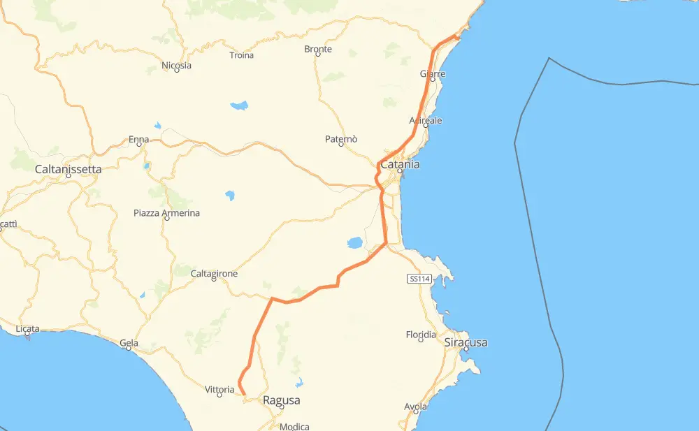
The distance from Comiso to Schisò is 141 kilometers by road including 69 kilometers on motorways. Road takes approximately 1 hour and 38 minutes and goes through Catania, Vittoria, Francofonte, Lentini, Carlentini, Misterbianco and Gravina di Catania.
| Shortest distance by air | 113 km ✈️ |
| Car route length | 141 km 🚗 |
| Driving time | 1 h 38 min |
| Fuel amount | 11.2 L |
| Fuel cost | 22 CAD |
| Point | Distance | Time | Fuel | |
| Comiso | 0 km | 00 min | 0.0 L | |
|
SP5 SS514 54 km, 42 min
|
||||
| Lentini | 54 km | 42 min | 3.2 L | |
|
SS194 18 km, 13 min
|
||||
| Carlentini | 72 km | 56 min | 5.5 L | |
|
SS114dir 26 km, 16 min
|
||||
| Catania | 98 km | 1 h 12 min | 6.1 L | |
|
RA15 23 km, 13 min
|
||||
| Gravina di Catania | 121 km | 1 h 26 min | 9.7 L | |
|
RA15 2 km, 01 min
|
||||
| San Giovanni la Punta | 123 km | 1 h 27 min | 9.8 L | |
|
RA15 1 km, 01 min
|
||||
| San Gregorio di Catania | 125 km | 1 h 28 min | 9.9 L | |
|
A18 4 km, 02 min
|
||||
| Aci Sant'Antonio | 128 km | 1 h 30 min | 10.0 L | |
|
A18 6 km, 03 min
|
||||
| Acireale | 135 km | 1 h 34 min | 10.5 L | |
|
A18 27 km, 16 min
|
||||
| Schisò | 162 km | 1 h 51 min | 12.9 L | |
Frequently Asked Questions
How much does it cost to drive from Comiso to Schisò?
Fuel cost: 22 CAD
This fuel cost is calculated as: (Route length 141 km / 100 km) * (Fuel consumption 8 L/100 km) * (Fuel price 1.96 CAD / L)
You can adjust fuel consumption and fuel price here.
How long is a car ride from Comiso to Schisò?
Driving time: 1 h 38 min
This time is calculated for driving at the maximum permitted speed, taking into account traffic rules restrictions.
- 45 km with a maximum speed 110 km/h = 24 min
- 16 km with a maximum speed 100 km/h = 9 min
- 37 km with a maximum speed 90 km/h = 24 min
- 23 km with a maximum speed 80 km/h = 17 min
- 6 km with a maximum speed 70 km/h = 5 min
- 9 km with a maximum speed 50 km/h = 11 min
- 4 km with a maximum speed 40 km/h = 5 min
The calculated driving time does not take into account intermediate stops and traffic jams.
How far is Comiso to Schisò by land?
The distance between Comiso and Schisò is 141 km by road including 69 km on motorways.
Precise satellite coordinates of highways were used for this calculation. The start and finish points are the centers of Comiso and Schisò respectively.
How far is Comiso to Schisò by plane?
The shortest distance (air line, as the crow flies) between Comiso and Schisò is 113 km.
This distance is calculated using the Haversine formula as a great-circle distance between two points on the surface of a sphere. The start and finish points are the centers of Comiso and Schisò respectively. Actual distance between airports may be different.
How many hours is Comiso from Schisò by plane?
Boeing 737 airliner needs 8 min to cover the distance of 113 km at a cruising speed of 800 km/h.
Small plane "Cessna 172" needs 30 min to flight this distance at average speed of 220 km/h.
This time is approximate and do not take into account takeoff and landing times, airport location and other real world factors.
How long is a helicopter ride from Comiso to Schisò?
Fast helicopter "Eurocopter AS350" or "Hughes OH-6 Cayuse" need 28 min to cover the distance of 113 km at a cruising speed of 240 km/h.
Popular "Robinson R44" needs 32 min to flight this distance at average speed of 210 km/h.
This time is approximate and do not take into account takeoff and landing times, aerodrome location and other real world factors.
What city is halfway between Comiso and Schisò?
The halfway point between Comiso and Schisò is Carlentini. It is located about 2 km from the exact midpoint by road.
The distance from Carlentini to Comiso is 72 km and driving will take about 55 min. The road between Carlentini and Schisò has length 69 km and will take approximately 42 min.
The other cities located close to halfway point:
Where is Comiso in relation to Schisò?
Comiso is located 113 km south-west of Schisò.
Comiso has geographic coordinates: latitude 36.95073, longitude 14.60746.
Schisò has geographic coordinates: latitude 37.82429, longitude 15.27084.