Distance between Charlotte NC and Huntingburg IN
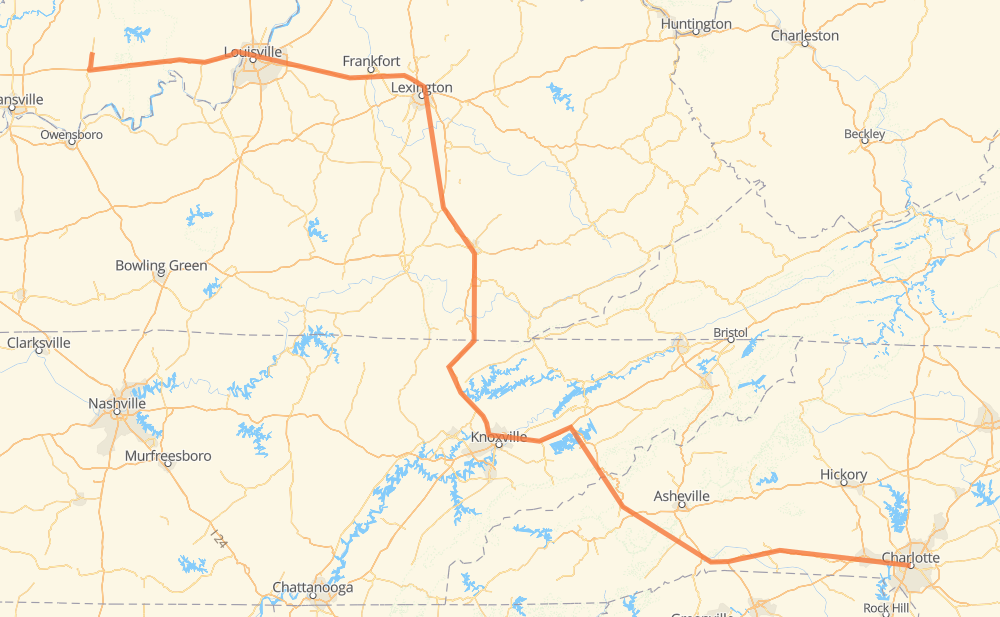
The distance from Charlotte to Huntingburg is 889 kilometers by road including 847 kilometers on motorways. Road takes approximately 8 hours and 36 minutes and goes through Asheville, Knoxville, Frankfort and Louisville.
| Shortest distance by air | 643 km ✈️ |
| Car route length | 889 km 🚗 |
| Driving time | 8 h 36 min |
| Fuel amount | 71.1 L |
| Fuel cost | 139.3 CAD |
| Point | Distance | Time | Fuel | |
| Charlotte | 0 km | 00 min | 0.0 L | |
|
NC 27 I 85 51 km, 31 min
|
||||
| Kings Mountain | 51 km | 31 min | 3.7 L | |
|
US 74 19 km, 12 min
|
||||
| Shelby | 71 km | 44 min | 5.0 L | |
|
US 74 116 km, 1 h 08 min
|
||||
| Asheville | 187 km | 1 h 52 min | 13.9 L | |
|
US 64 Truck I 40 105 km, 1 h 06 min
|
||||
| Newport Housing Authority | 292 km | 2 h 59 min | 23.1 L | |
|
I 40 46 km, 25 min
|
||||
| Sevierville | 338 km | 3 h 25 min | 26.6 L | |
|
I 40 30 km, 17 min
|
||||
| Knoxville | 368 km | 3 h 42 min | 29.4 L | |
|
I 75 316 km, 2 h 55 min
|
||||
| Frankfort | 684 km | 6 h 38 min | 54.6 L | |
|
I 64 64 km, 36 min
|
||||
| Louisville | 748 km | 7 h 15 min | 58.3 L | |
|
I 64 140 km, 1 h 21 min
|
||||
| Huntingburg | 889 km | 8 h 36 min | 70.8 L | |
Hotels of Huntingburg
Frequently Asked Questions
How much does it cost to drive from Charlotte to Huntingburg?
Fuel cost: 139.3 CAD
This fuel cost is calculated as: (Route length 889 km / 100 km) * (Fuel consumption 8 L/100 km) * (Fuel price 1.96 CAD / L)
You can adjust fuel consumption and fuel price here.
How long is a car ride from Charlotte to Huntingburg?
Driving time: 8 h 36 min
This time is calculated for driving at the maximum permitted speed, taking into account traffic rules restrictions.
- 504 km with a maximum speed 110 km/h = 4 h 34 min
- 136 km with a maximum speed 105 km/h = 1 h 17 min
- 7 km with a maximum speed 100 km/h = 4 min
- 95 km with a maximum speed 97 km/h = 59 min
- 8 km with a maximum speed 90 km/h = 5 min
- 125 km with a maximum speed 89 km/h = 1 h 24 min
- 2 km with a maximum speed 80 km/h = 1 min
- 11 km with a maximum speed 80 km/h = 7 min
- 2 km with a maximum speed 72 km/h = 1 min
The calculated driving time does not take into account intermediate stops and traffic jams.
How far is Charlotte to Huntingburg by land?
The distance between Charlotte and Huntingburg is 889 km by road including 847 km on motorways.
Precise satellite coordinates of highways were used for this calculation. The start and finish points are the centers of Charlotte and Huntingburg respectively.
How far is Charlotte to Huntingburg by plane?
The shortest distance (air line, as the crow flies) between Charlotte and Huntingburg is 643 km.
This distance is calculated using the Haversine formula as a great-circle distance between two points on the surface of a sphere. The start and finish points are the centers of Charlotte and Huntingburg respectively. Actual distance between airports may be different.
How many hours is Charlotte from Huntingburg by plane?
Boeing 737 airliner needs 48 min to cover the distance of 643 km at a cruising speed of 800 km/h.
Small plane "Cessna 172" needs 2 h 55 min to flight this distance at average speed of 220 km/h.
This time is approximate and do not take into account takeoff and landing times, airport location and other real world factors.
How long is a helicopter ride from Charlotte to Huntingburg?
Fast helicopter "Eurocopter AS350" or "Hughes OH-6 Cayuse" need 2 h 40 min to cover the distance of 643 km at a cruising speed of 240 km/h.
Popular "Robinson R44" needs 3 h 3 min to flight this distance at average speed of 210 km/h.
This time is approximate and do not take into account takeoff and landing times, aerodrome location and other real world factors.
What city is halfway between Charlotte and Huntingburg?
The halfway point between Charlotte and Huntingburg is Mountain Ash. It is located about 24 km from the exact midpoint by road.
The distance from Mountain Ash to Charlotte is 468 km and driving will take about 4 h 40 min. The road between Mountain Ash and Huntingburg has length 420 km and will take approximately 3 h 56 min.
The other cities located close to halfway point:
Where is Charlotte in relation to Huntingburg?
Charlotte is located 643 km south-east of Huntingburg.
Charlotte has geographic coordinates: latitude 35.22708, longitude -80.84313.
Huntingburg has geographic coordinates: latitude 38.29894, longitude -86.955.
Which highway goes from Charlotte to Huntingburg?
The route from Charlotte to Huntingburg follows I 75, I 64, I 40, US 74.
Other minor sections pass along the road:
- US 64 Truck: 58 km
- I 26: 55 km
- I 85: 37 km
- US 25: 18 km
- US 231: 12 km
- US 150: 10 km
- SR 63: 10 km
- US 25W: 9 km
- SR 62: 5 km
- I 275: 5 km
- NC 27: 5 km
- NC 226: 5 km
- NC 108 Truck: 2 km
- US 74 Bypass: 2 km
- US 421: 2 km
- US 29: 2 km
- US 74 Business: 1 km