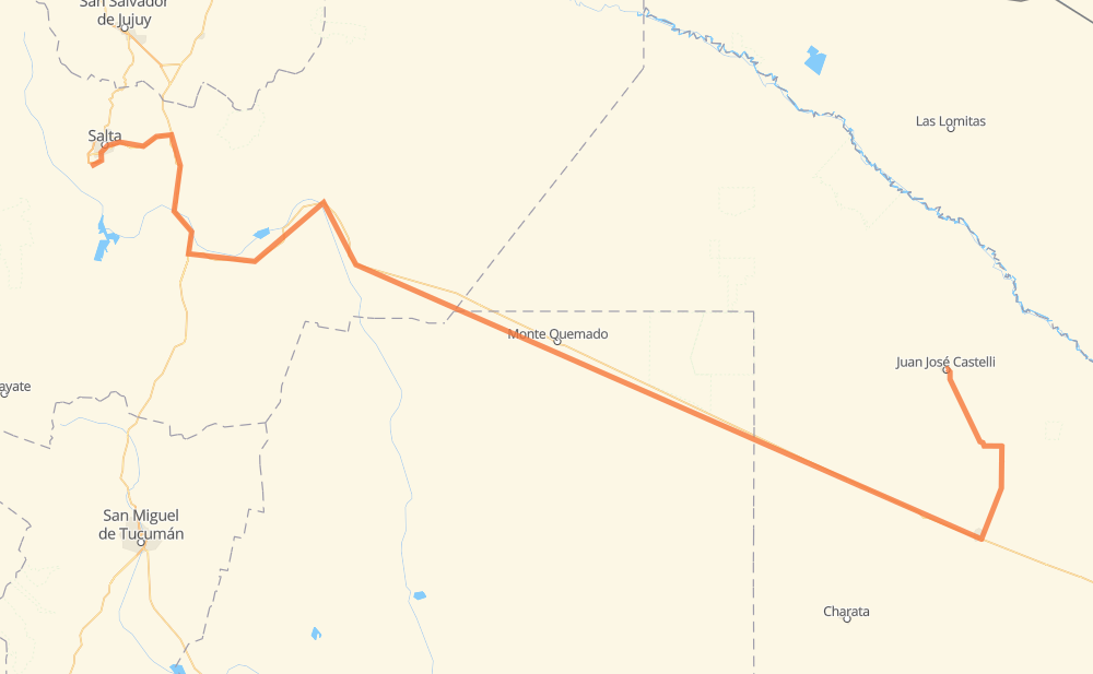
Distance between Cerrillos and Juan José Castelli
The distance from Cerrillos to Juan José Castelli is 783 kilometers by road including 10 kilometers on motorways. Road takes approximately 9 hours and 26 minutes and goes through Salta, Presidencia Roque Sáenz Peña, Joaquín V. González, Monte Quemado, Pampa del Infierno and Tres Isletas.
| Shortest distance by air | 503 km ✈️ |
| Car route length | 783 km 🚗 |
| Driving time | 9 h 26 min |
| Fuel amount | 62.6 L |
| Fuel cost | 122.8 CAD |
| Point | Distance | Time | Fuel | |
| Cerrillos | 0 km | 00 min | 0.0 L | |
|
RN68 RP21 19 km, 14 min
|
||||
| Salta | 19 km | 14 min | 1.0 L | |
|
RN9 43 km, 28 min
|
||||
| Torzalito | 61 km | 43 min | 4.5 L | |
|
RN9 101 km, 1 h 08 min
|
||||
| La Armonía | 163 km | 1 h 52 min | 12.2 L | |
|
RN16 38 km, 28 min
|
||||
| El Tunal | 201 km | 2 h 20 min | 13.8 L | |
|
RN16 46 km, 34 min
|
||||
| Joaquín V. González | 247 km | 2 h 55 min | 18.3 L | |
|
RN16 184 km, 2 h 17 min
|
||||
| Monte Quemado | 431 km | 5 h 13 min | 28.2 L | |
|
RN16 156 km, 1 h 52 min
|
||||
| Pampa del Infierno | 587 km | 7 h 05 min | 45.3 L | |
|
RN16 75 km, 55 min
|
||||
| Presidencia Roque Sáenz Peña | 662 km | 8 h 01 min | 50.9 L | |
|
RN16 RN95 121 km, 1 h 25 min
|
||||
| Juan José Castelli | 783 km | 9 h 26 min | 61.8 L | |
Frequently Asked Questions
How much does it cost to drive from Cerrillos to Juan José Castelli?
Fuel cost: 122.8 CAD
This fuel cost is calculated as: (Route length 783 km / 100 km) * (Fuel consumption 8 L/100 km) * (Fuel price 1.96 CAD / L)
You can adjust fuel consumption and fuel price here.
How long is a car ride from Cerrillos to Juan José Castelli?
Driving time: 9 h 26 min
This time is calculated for driving at the maximum permitted speed, taking into account traffic rules restrictions.
- 2 km with a maximum speed 100 km/h = 1 min
- 277 km with a maximum speed 90 km/h = 3 h 4 min
- 495 km with a maximum speed 80 km/h = 6 h 11 min
- 5 km with a maximum speed 60 km/h = 5 min
- 3 km with a maximum speed 50 km/h = 3 min
The calculated driving time does not take into account intermediate stops and traffic jams.
How far is Cerrillos to Juan José Castelli by land?
The distance between Cerrillos and Juan José Castelli is 783 km by road including 10 km on motorways.
Precise satellite coordinates of highways were used for this calculation. The start and finish points are the centers of Cerrillos and Juan José Castelli respectively.
How far is Cerrillos to Juan José Castelli by plane?
The shortest distance (air line, as the crow flies) between Cerrillos and Juan José Castelli is 503 km.
This distance is calculated using the Haversine formula as a great-circle distance between two points on the surface of a sphere. The start and finish points are the centers of Cerrillos and Juan José Castelli respectively. Actual distance between airports may be different.
How many hours is Cerrillos from Juan José Castelli by plane?
Boeing 737 airliner needs 37 min to cover the distance of 503 km at a cruising speed of 800 km/h.
Small plane "Cessna 172" needs 2 h 17 min to flight this distance at average speed of 220 km/h.
This time is approximate and do not take into account takeoff and landing times, airport location and other real world factors.
How long is a helicopter ride from Cerrillos to Juan José Castelli?
Fast helicopter "Eurocopter AS350" or "Hughes OH-6 Cayuse" need 2 h 5 min to cover the distance of 503 km at a cruising speed of 240 km/h.
Popular "Robinson R44" needs 2 h 23 min to flight this distance at average speed of 210 km/h.
This time is approximate and do not take into account takeoff and landing times, aerodrome location and other real world factors.
What city is halfway between Cerrillos and Juan José Castelli?
The halfway point between Cerrillos and Juan José Castelli is Monte Quemado. It is located about 39 km from the exact midpoint by road.
The distance from Monte Quemado to Cerrillos is 431 km and driving will take about 5 h 13 min. The road between Monte Quemado and Juan José Castelli has length 352 km and will take approximately 4 h 13 min.
The other cities located close to halfway point:
Where is Cerrillos in relation to Juan José Castelli?
Cerrillos is located 503 km west of Juan José Castelli.
Cerrillos has geographic coordinates: latitude -24.90147, longitude -65.48755.
Juan José Castelli has geographic coordinates: latitude -25.94671, longitude -60.62002.
Which highway goes from Cerrillos to Juan José Castelli?
The route from Cerrillos to Juan José Castelli follows RN16, RN9, RN95.
Other minor sections pass along the road:
- RN34: 77 km
- RP21: 4 km
- RN68: 4 km