Distance between Cabo San Lucas and José María Morelos (San José)
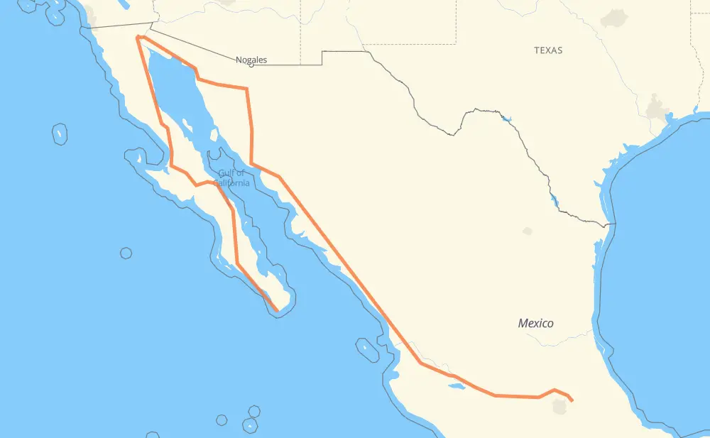
The distance from Cabo San Lucas to José María Morelos (San José) is 4,090 kilometers by road including 2,053 kilometers on motorways. Road takes approximately 48 hours and 15 minutes and goes through La Paz, Heroica Caborca, Hermosillo, Navojoa, Los Mochis, Gabriel Leyva Solano and Dimas (Estación Dimas).
| Shortest distance by air | 1,227 km ✈️ |
| Car route length | 4,090 km 🚗 |
| Driving time | 48 h 15 min |
| Fuel amount | 327.2 L |
| Fuel cost | 641.2 CAD |
| Toll roads cost | 2,316 + ? MXN |
| Point | Distance | Time | Fuel | |
| Cabo San Lucas | 0 km | 00 min | 0.0 L | |
|
MEX 19 153 km, 1 h 45 min
|
||||
| La Paz | 153 km | 1 h 45 min | 11.8 L | |
|
MEX 1 1,745 km, 22 h 26 min
|
||||
| Heroica Caborca | 1,898 km | 24 h 12 min | 151.2 L | |
|
MEX 2 MEX 15D 272 km, 2 h 49 min
|
||||
| Hermosillo | 2,171 km | 27 h 01 min | 173.4 L | |
|
MEX 15 MEX 15D 323 km, 3 h 29 min
|
||||
| Navojoa | 2,493 km | 30 h 30 min | 199.0 L | |
|
MEX 15D 159 km, 1 h 55 min
|
||||
| Los Mochis | 2,652 km | 32 h 26 min | 212.0 L | |
|
MEX 15D 44 km, 31 min
|
||||
| Gabriel Leyva Solano | 2,696 km | 32 h 58 min | 214.7 L | |
|
MEX 15D 289 km, 3 h 09 min
|
||||
| Dimas (Estación Dimas) | 2,985 km | 36 h 08 min | 237.7 L | |
|
MEX 15D 334 km, 3 h 38 min
|
||||
| Tepic | 3,319 km | 39 h 46 min | 264.8 L | |
|
MEX 15D 222 km, 2 h 16 min
|
||||
| Tonalá | 3,540 km | 42 h 03 min | 282.6 L | |
|
MEX 15D 564 km, 6 h 11 min
|
||||
| José María Morelos (San José) | 4,104 km | 48 h 15 min | 328.3 L | |
Frequently Asked Questions
How many toll booths are there from Cabo San Lucas to José María Morelos (San José)?
There are 28 toll booths between Cabo San Lucas and José María Morelos (San José): Santa Ana, Hermosillo, Guaymas, Libramiento Cd Obregon, Fundicion, Estacion Don La Jaula, San Miguel, Sinaloa, Las Brisas, San Pedro km 197+100, Costa Rica, Marmol, El Rosario, Ruiz, Trapichillo, Santa Maria del Oro, Plan de Barrancas, La Joya, Ocotlán, Zinapecuaro, Contepec, Panindicuaro, Ecuandureo, Ciudad Sahagun, Atlacomulco — Maravatio, Atlacomulco 2, Arenal and El Pisal.
How much does the toll booths cost from Cabo San Lucas to José María Morelos (San José)?
Toll roads cost: Santa Ana (120 MXN) + Hermosillo (90 MXN) + Guaymas (38 MXN) + Libramiento Cd Obregon (?) + Fundicion (90 MXN) + Estacion Don La Jaula (90 MXN) + San Miguel (69 MXN) + Sinaloa (24 MXN) + Las Brisas (76 MXN) + El Pisal (73 MXN) + San Pedro km 197+100 (34 MXN) + Costa Rica (152 MXN) + Marmol (131 MXN) + El Rosario (140 MXN) + Ruiz (120 MXN) + Trapichillo (80 MXN) + Santa Maria del Oro (115 MXN) + Plan de Barrancas (195 MXN) + Arenal (131 MXN) + La Joya (?) + Ocotlán (226 MXN) + Ecuandureo (111 MXN) + Panindicuaro (?) + Zinapecuaro (161 MXN) + Contepec (?) + Atlacomulco — Maravatio (50 MXN) + Atlacomulco 2 (?) + Ciudad Sahagun (?) = 2,316 + ? MXN
How much does it cost to drive from Cabo San Lucas to José María Morelos (San José)?
Fuel cost: 641.2 CAD
This fuel cost is calculated as: (Route length 4,090 km / 100 km) * (Fuel consumption 8 L/100 km) * (Fuel price 1.96 CAD / L)
You can adjust fuel consumption and fuel price here.
Toll roads cost: 2,316 + ? MXN
How long is a car ride from Cabo San Lucas to José María Morelos (San José)?
Driving time: 48 h 15 min
This time is calculated for driving at the maximum permitted speed, taking into account traffic rules restrictions.
- 430 km with a maximum speed 110 km/h = 3 h 54 min
- 848 km with a maximum speed 100 km/h = 8 h 28 min
- 1,278 km with a maximum speed 90 km/h = 14 h 11 min
- 1,326 km with a maximum speed 80 km/h = 16 h 34 min
- 113 km with a maximum speed 70 km/h = 1 h 36 min
- 52 km with a maximum speed 60 km/h = 51 min
- 8 km with a maximum speed 50 km/h = 9 min
- 2 km with a maximum speed 40 km/h = 3 min
- 46 km with a maximum speed 20 km/h = 2 h 18 min
- 1 km with a maximum speed 10 km/h = 6 min
The calculated driving time does not take into account intermediate stops and traffic jams.
How far is Cabo San Lucas to José María Morelos (San José) by land?
The distance between Cabo San Lucas and José María Morelos (San José) is 4,090 km by road including 2,053 km on motorways.
Precise satellite coordinates of highways were used for this calculation. The start and finish points are the centers of Cabo San Lucas and José María Morelos (San José) respectively.
How far is Cabo San Lucas to José María Morelos (San José) by plane?
The shortest distance (air line, as the crow flies) between Cabo San Lucas and José María Morelos (San José) is 1,227 km.
This distance is calculated using the Haversine formula as a great-circle distance between two points on the surface of a sphere. The start and finish points are the centers of Cabo San Lucas and José María Morelos (San José) respectively. Actual distance between airports may be different.
How many hours is Cabo San Lucas from José María Morelos (San José) by plane?
Boeing 737 airliner needs 1 h 32 min to cover the distance of 1,227 km at a cruising speed of 800 km/h.
Small plane "Cessna 172" needs 5 h 34 min to flight this distance at average speed of 220 km/h.
This time is approximate and do not take into account takeoff and landing times, airport location and other real world factors.
How long is a helicopter ride from Cabo San Lucas to José María Morelos (San José)?
Fast helicopter "Eurocopter AS350" or "Hughes OH-6 Cayuse" need 5 h 6 min to cover the distance of 1,227 km at a cruising speed of 240 km/h.
Popular "Robinson R44" needs 5 h 50 min to flight this distance at average speed of 210 km/h.
This time is approximate and do not take into account takeoff and landing times, aerodrome location and other real world factors.
What city is halfway between Cabo San Lucas and José María Morelos (San José)?
The halfway point between Cabo San Lucas and José María Morelos (San José) is San Fernando. It is located about 2 km from the exact midpoint by road.
The distance from San Fernando to Cabo San Lucas is 2,043 km and driving will take about 25 h 46 min. The road between San Fernando and José María Morelos (San José) has length 2,046 km and will take approximately 22 h 29 min.
The other cities located close to halfway point:
Where is Cabo San Lucas in relation to José María Morelos (San José)?
Cabo San Lucas is located 1,227 km north-west of José María Morelos (San José).
Cabo San Lucas has geographic coordinates: latitude 22.89381, longitude -109.91113.
José María Morelos (San José) has geographic coordinates: latitude 19.68083, longitude -98.57639.
Which highway goes from Cabo San Lucas to José María Morelos (San José)?
The route from Cabo San Lucas to José María Morelos (San José) follows MEX 15D, MEX 1, MEX 5, SON 003, MEX M40D, BCS 53, BC 5, MEX 19, SON 3.
Other minor sections pass along the road:
- MEX 2D: 75 km
- SON 44: 61 km
- MEX 15: 36 km
- MEX 90: 31 km
- MEX 70: 31 km
- MEX 2: 29 km
- BC 4: 27 km
- MEX 80D: 18 km
- MEX 80: 11 km
- MEX 23: 8 km
- BC 41: 7 km
- MEX 115: 7 km
- MEX 040D: 6 km
- SON 34: 3 km
- MEX 15d: 3 km