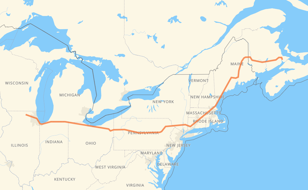
The distance from Belvidere to Memramcook is 2,583 kilometers by road including 2,569 kilometers on motorways. Road takes approximately 24 hours and 37 minutes and goes through Chicago, South Bend, Toledo, Elyria, Scranton, Waterbury and Hartford.
How much does it cost to drive from Belvidere to Memramcook?
Fuel cost:
405 CAD
This fuel cost is calculated as: (Route length 2,583 km / 100 km) * (Fuel consumption 8 L/100 km) * (Fuel price 1.96 CAD / L)
You can adjust fuel consumption and fuel price here.
How long is a car ride from Belvidere to Memramcook?
Driving time:
24 h 37 min
This time is calculated for driving at the maximum permitted speed, taking into account traffic rules restrictions.
1,746 km with a maximum speed 110 km/h = 15 h 52 min
496 km with a maximum speed 105 km/h = 4 h 44 min
64 km with a maximum speed 100 km/h = 38 min
10 km with a maximum speed 97 km/h = 6 min
105 km with a maximum speed 89 km/h = 1 h 11 min
17 km with a maximum speed 80 km/h = 12 min
122 km with a maximum speed 80 km/h = 1 h 31 min
16 km with a maximum speed 72 km/h = 12 min
1 km with a maximum speed 64 km/h = 1 min
2 km with a maximum speed 56 km/h = 2 min
1 km with a maximum speed 50 km/h = 1 min
The calculated driving time does not take into account intermediate stops and traffic jams.
How far is Belvidere to Memramcook by land?
The distance between Belvidere and Memramcook is 2,583 km by road including 2,569 km on motorways.
Precise satellite coordinates of highways were used for this calculation. The start and finish points are the centers of Belvidere and Memramcook respectively.
How far is Belvidere to Memramcook by plane?
The shortest distance (air line, as the crow flies) between Belvidere and Memramcook is 1,974 km.
This distance is calculated using the Haversine formula as a great-circle distance between two points on the surface of a sphere. The start and finish points are the centers of Belvidere and Memramcook respectively. Actual distance between airports may be different.
How many hours is Belvidere from Memramcook by plane?
Boeing 737 airliner needs 2 h 28 min to cover the distance of 1,974 km at a cruising speed of 800 km/h.
Small plane "Cessna 172" needs 8 h 58 min to flight this distance at average speed of 220 km/h.
This time is approximate and do not take into account takeoff and landing times, airport location and other real world factors.
How long is a helicopter ride from Belvidere to Memramcook?
Fast helicopter "Eurocopter AS350" or "Hughes OH-6 Cayuse" need 8 h 13 min to cover the distance of 1,974 km at a cruising speed of 240 km/h.
Popular "Robinson R44" needs 9 h 24 min to flight this distance at average speed of 210 km/h.
This time is approximate and do not take into account takeoff and landing times, aerodrome location and other real world factors.
What city is halfway between Belvidere and Memramcook?
The halfway point between Belvidere and Memramcook is Blooming Grove.
The distance from Blooming Grove to Belvidere is 1,291 km and driving will take about 12 h 4 min. The road between Blooming Grove and Memramcook has length 1,292 km and will take approximately 12 h 33 min.
The other cities located close to halfway point:
Dunmore is in 1,247 km from Belvidere and 1,336 km from Memramcook
Scranton is in 1,240 km from Belvidere and 1,343 km from Memramcook
Dupont is in 1,229 km from Belvidere and 1,354 km from Memramcook
Where is Belvidere in relation to Memramcook?
Belvidere is located 1,974 km west of Memramcook.
Belvidere has geographic coordinates: latitude 42.258, longitude -88.84173.
Memramcook has geographic coordinates: latitude 45.97637, longitude -64.56696.
Which highway goes from Belvidere to Memramcook?
The route from Belvidere to Memramcook follows I 80, I 90, I 95, I 84, 2.