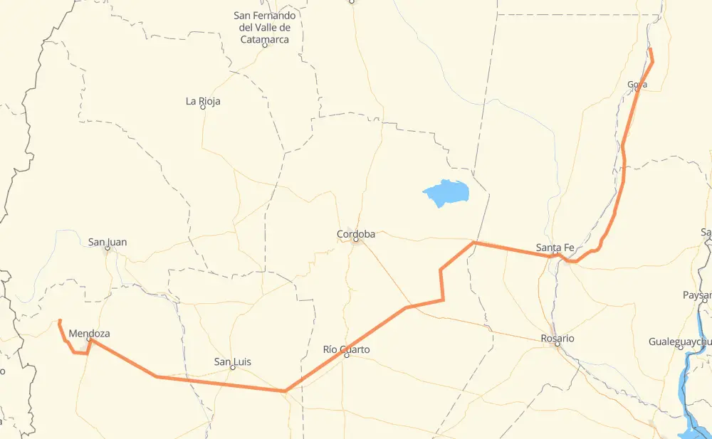
Distance between Bella Vista and Uspallata
The distance from Bella Vista to Uspallata is 1,517 kilometers by road including 82 kilometers on motorways. Road takes approximately 17 hours and 46 minutes and goes through Paraná, Villa María, Río Cuarto and San Luis.
| Shortest distance by air | 1,086 km ✈️ |
| Car route length | 1,517 km 🚗 |
| Driving time | 17 h 46 min |
| Fuel amount | 121.3 L |
| Fuel cost | 237.8 CAD |
| Point | Distance | Time | Fuel | |
| Bella Vista | 0 km | 00 min | 0.0 L | |
|
RP27 98 km, 1 h 10 min
|
||||
| Goya | 98 km | 1 h 10 min | 6.0 L | |
|
RN12 89 km, 1 h 05 min
|
||||
| Esquina | 187 km | 2 h 15 min | 13.1 L | |
|
RN12 248 km, 2 h 52 min
|
||||
| Paraná | 435 km | 5 h 08 min | 34.4 L | |
|
RN168 25 km, 17 min
|
||||
| Candioti Norte | 459 km | 5 h 25 min | 36.7 L | |
|
RN19 220 km, 2 h 28 min
|
||||
| Las Varillas | 679 km | 7 h 54 min | 53.5 L | |
|
RP13 RP2 113 km, 1 h 18 min
|
||||
| Villa María | 792 km | 9 h 12 min | 63.3 L | |
|
RP2 RN158 140 km, 1 h 51 min
|
||||
| Río Cuarto | 932 km | 11 h 04 min | 73.9 L | |
|
RN8 212 km, 2 h 25 min
|
||||
| San Luis | 1,144 km | 13 h 30 min | 91.0 L | |
|
RN7 373 km, 4 h 15 min
|
||||
| Uspallata | 1,517 km | 17 h 45 min | 120.8 L | |
Hotels of Uspallata
Frequently Asked Questions
How much does it cost to drive from Bella Vista to Uspallata?
Fuel cost: 237.8 CAD
This fuel cost is calculated as: (Route length 1,517 km / 100 km) * (Fuel consumption 8 L/100 km) * (Fuel price 1.96 CAD / L)
You can adjust fuel consumption and fuel price here.
How long is a car ride from Bella Vista to Uspallata?
Driving time: 17 h 46 min
This time is calculated for driving at the maximum permitted speed, taking into account traffic rules restrictions.
- 40 km with a maximum speed 110 km/h = 21 min
- 4 km with a maximum speed 100 km/h = 2 min
- 1,124 km with a maximum speed 90 km/h = 12 h 29 min
- 273 km with a maximum speed 80 km/h = 3 h 24 min
- 48 km with a maximum speed 60 km/h = 48 min
- 4 km with a maximum speed 50 km/h = 4 min
- 2 km with a maximum speed 45 km/h = 2 min
- 19 km with a maximum speed 40 km/h = 28 min
- 1 km with a maximum speed 30 km/h = 1 min
The calculated driving time does not take into account intermediate stops and traffic jams.
How far is Bella Vista to Uspallata by land?
The distance between Bella Vista and Uspallata is 1,517 km by road including 82 km on motorways.
Precise satellite coordinates of highways were used for this calculation. The start and finish points are the centers of Bella Vista and Uspallata respectively.
How far is Bella Vista to Uspallata by plane?
The shortest distance (air line, as the crow flies) between Bella Vista and Uspallata is 1,086 km.
This distance is calculated using the Haversine formula as a great-circle distance between two points on the surface of a sphere. The start and finish points are the centers of Bella Vista and Uspallata respectively. Actual distance between airports may be different.
How many hours is Bella Vista from Uspallata by plane?
Boeing 737 airliner needs 1 h 21 min to cover the distance of 1,086 km at a cruising speed of 800 km/h.
Small plane "Cessna 172" needs 4 h 56 min to flight this distance at average speed of 220 km/h.
This time is approximate and do not take into account takeoff and landing times, airport location and other real world factors.
How long is a helicopter ride from Bella Vista to Uspallata?
Fast helicopter "Eurocopter AS350" or "Hughes OH-6 Cayuse" need 4 h 31 min to cover the distance of 1,086 km at a cruising speed of 240 km/h.
Popular "Robinson R44" needs 5 h 10 min to flight this distance at average speed of 210 km/h.
This time is approximate and do not take into account takeoff and landing times, aerodrome location and other real world factors.
What city is halfway between Bella Vista and Uspallata?
The halfway point between Bella Vista and Uspallata is Alto Alegre. It is located about 2 km from the exact midpoint by road.
The distance from Alto Alegre to Bella Vista is 761 km and driving will take about 8 h 49 min. The road between Alto Alegre and Uspallata has length 756 km and will take approximately 8 h 56 min.
The other cities located close to halfway point:
Where is Bella Vista in relation to Uspallata?
Bella Vista is located 1,086 km north-east of Uspallata.
Bella Vista has geographic coordinates: latitude -28.50737, longitude -59.04523.
Uspallata has geographic coordinates: latitude -32.59081, longitude -69.34655.
Which highway goes from Bella Vista to Uspallata?
The route from Bella Vista to Uspallata follows RN7, RN12, RN158, RN19, RN8.
Other minor sections pass along the road:
- RP27: 79 km
- RP2: 61 km
- RP3: 48 km
- RN168: 35 km
- RN40: 21 km
- RP13: 12 km
- AP01: 10 km
- RN40 RN7: 2 km