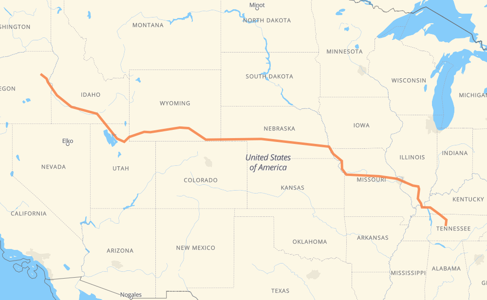
The distance from Baker City to Franklin is 3,325 kilometers by road including 3,229 kilometers on motorways. Road takes approximately 31 hours and 6 minutes and goes through Ogden, Rock Springs, Laramie, Cheyenne, North Platte, Lincoln and Kansas City.
How much does it cost to drive from Baker City to Franklin?
Fuel cost:
521.4 CAD
This fuel cost is calculated as: (Route length 3,325 km / 100 km) * (Fuel consumption 8 L/100 km) * (Fuel price 1.96 CAD / L)
You can adjust fuel consumption and fuel price here.
How long is a car ride from Baker City to Franklin?
Driving time:
31 h 6 min
This time is calculated for driving at the maximum permitted speed, taking into account traffic rules restrictions.
2,788 km with a maximum speed 110 km/h = 25 h 20 min
134 km with a maximum speed 105 km/h = 1 h 16 min
116 km with a maximum speed 100 km/h = 1 h 9 min
56 km with a maximum speed 97 km/h = 34 min
66 km with a maximum speed 90 km/h = 44 min
64 km with a maximum speed 89 km/h = 43 min
87 km with a maximum speed 80 km/h = 1 h 5 min
11 km with a maximum speed 72 km/h = 9 min
The calculated driving time does not take into account intermediate stops and traffic jams.
How far is Baker City to Franklin by land?
The distance between Baker City and Franklin is 3,325 km by road including 3,229 km on motorways.
Precise satellite coordinates of highways were used for this calculation. The start and finish points are the centers of Baker City and Franklin respectively.
How far is Baker City to Franklin by plane?
The shortest distance (air line, as the crow flies) between Baker City and Franklin is 2,783 km.
This distance is calculated using the Haversine formula as a great-circle distance between two points on the surface of a sphere. The start and finish points are the centers of Baker City and Franklin respectively. Actual distance between airports may be different.
How many hours is Baker City from Franklin by plane?
Boeing 737 airliner needs 3 h 28 min to cover the distance of 2,783 km at a cruising speed of 800 km/h.
Small plane "Cessna 172" needs 12 h 39 min to flight this distance at average speed of 220 km/h.
This time is approximate and do not take into account takeoff and landing times, airport location and other real world factors.
How long is a helicopter ride from Baker City to Franklin?
Fast helicopter "Eurocopter AS350" or "Hughes OH-6 Cayuse" need 11 h 35 min to cover the distance of 2,783 km at a cruising speed of 240 km/h.
Popular "Robinson R44" needs 13 h 15 min to flight this distance at average speed of 210 km/h.
This time is approximate and do not take into account takeoff and landing times, aerodrome location and other real world factors.
What city is halfway between Baker City and Franklin?
The halfway point between Baker City and Franklin is Ogallala. It is located about 3 km from the exact midpoint by road.
The distance from Ogallala to Baker City is 1,659 km and driving will take about 15 h 23 min. The road between Ogallala and Franklin has length 1,666 km and will take approximately 15 h 43 min.
The other cities located close to halfway point:
North Platte is in 1,721 km from Baker City and 1,604 km from Franklin
Sidney is in 1,555 km from Baker City and 1,770 km from Franklin
Pine Bluffs is in 1,447 km from Baker City and 1,878 km from Franklin
Where is Baker City in relation to Franklin?
Baker City is located 2,783 km north-west of Franklin.
Baker City has geographic coordinates: latitude 44.77487, longitude -117.83438.
Franklin has geographic coordinates: latitude 35.92519, longitude -86.86894.
Which highway goes from Baker City to Franklin?
The route from Baker City to Franklin follows I 80, I 84, US 30, I 70, I 24, US 40, I 29, US 26, I 64.