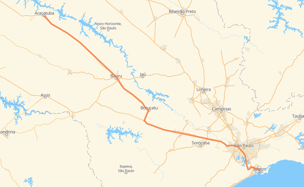
Distance between Araçatuba and Santos
The distance from Araçatuba to Santos is 589 kilometers by road including 567 kilometers on motorways. Road takes approximately 6 hours and goes through Barueri, Distrito Industrial II, Vila São José, Jardim da Represa, Capivari, Imigrantes and Cota 200.
| Shortest distance by air | 521 km ✈️ |
| Car route length | 589 km 🚗 |
| Driving time | 6 h |
| Fuel amount | 47.1 L |
| Fuel cost | 92.3 CAD |
| Point | Distance | Time | Fuel | |
| -21.20799, -50.43902 | 0 km | 00 min | 0.0 L | |
|
SP-300 229 km, 2 h 13 min
|
||||
| Distrito Industrial II | 229 km | 2 h 13 min | 35.7 L | |
|
SP-300 SP-280 262 km, 2 h 37 min
|
||||
| Barueri | 491 km | 4 h 51 min | 56.6 L | |
|
SP-280 SPM-280 E 10 km, 06 min
|
||||
| Vila São José | 501 km | 4 h 57 min | 57.8 L | |
|
BR-374 SP-160 38 km, 28 min
|
||||
| Jardim da Represa | 539 km | 5 h 26 min | 60.9 L | |
|
SP-160 9 km, 05 min
|
||||
| Capivari | 549 km | 5 h 31 min | 61.6 L | |
|
SP-160 11 km, 07 min
|
||||
| Imigrantes | 559 km | 5 h 39 min | 61.9 L | |
|
SP-160 10 km, 07 min
|
||||
| Cota 200 | 569 km | 5 h 46 min | 63.3 L | |
|
SP-160 7 km, 04 min
|
||||
| Jardim Casqueiro | 576 km | 5 h 51 min | 63.9 L | |
|
SP-150 12 km, 08 min
|
||||
| Santos | 589 km | 6 h 00 min | 64.9 L | |
Hotels of Santos
Frequently Asked Questions
How much does it cost to drive from Araçatuba to Santos?
Fuel cost: 92.3 CAD
This fuel cost is calculated as: (Route length 589 km / 100 km) * (Fuel consumption 8 L/100 km) * (Fuel price 1.96 CAD / L)
You can adjust fuel consumption and fuel price here.
How long is a car ride from Araçatuba to Santos?
Driving time: 6 h
This time is calculated for driving at the maximum permitted speed, taking into account traffic rules restrictions.
- 417 km with a maximum speed 110 km/h = 3 h 47 min
- 43 km with a maximum speed 100 km/h = 25 min
- 17 km with a maximum speed 90 km/h = 11 min
- 88 km with a maximum speed 80 km/h = 1 h 5 min
- 6 km with a maximum speed 60 km/h = 5 min
- 10 km with a maximum speed 50 km/h = 12 min
- 8 km with a maximum speed 40 km/h = 11 min
The calculated driving time does not take into account intermediate stops and traffic jams.
How far is Araçatuba to Santos by land?
The distance between Araçatuba and Santos is 589 km by road including 567 km on motorways.
Precise satellite coordinates of highways were used for this calculation. The start and finish points are the centers of Araçatuba and Santos respectively.
How far is Araçatuba to Santos by plane?
The shortest distance (air line, as the crow flies) between Araçatuba and Santos is 521 km.
This distance is calculated using the Haversine formula as a great-circle distance between two points on the surface of a sphere. The start and finish points are the centers of Araçatuba and Santos respectively. Actual distance between airports may be different.
How many hours is Araçatuba from Santos by plane?
Boeing 737 airliner needs 39 min to cover the distance of 521 km at a cruising speed of 800 km/h.
Small plane "Cessna 172" needs 2 h 22 min to flight this distance at average speed of 220 km/h.
This time is approximate and do not take into account takeoff and landing times, airport location and other real world factors.
How long is a helicopter ride from Araçatuba to Santos?
Fast helicopter "Eurocopter AS350" or "Hughes OH-6 Cayuse" need 2 h 10 min to cover the distance of 521 km at a cruising speed of 240 km/h.
Popular "Robinson R44" needs 2 h 28 min to flight this distance at average speed of 210 km/h.
This time is approximate and do not take into account takeoff and landing times, aerodrome location and other real world factors.
What city is halfway between Araçatuba and Santos?
The halfway point between Araçatuba and Santos is Distrito Industrial II. It is located about 66 km from the exact midpoint by road.
The distance from Distrito Industrial II to Araçatuba is 229 km and driving will take about 2 h 13 min. The road between Distrito Industrial II and Santos has length 360 km and will take approximately 3 h 46 min.
Where is Araçatuba in relation to Santos?
Araçatuba is located 521 km north-west of Santos.
Araçatuba has geographic coordinates: latitude -21.20799, longitude -50.43902.
Santos has geographic coordinates: latitude -23.96083, longitude -46.33389.
Which highway goes from Araçatuba to Santos?
The route from Araçatuba to Santos follows SP-300, SP-280, BR-374.
Other minor sections pass along the road:
- BR-267: 50 km
- SP-160: 49 km
- SP-209: 20 km
- SP-015: 9 km
- SPM-280 E: 6 km
- SP-150: 6 km
- BR-050: 6 km
- BR-116: 4 km
- SPI-059/150: 3 km