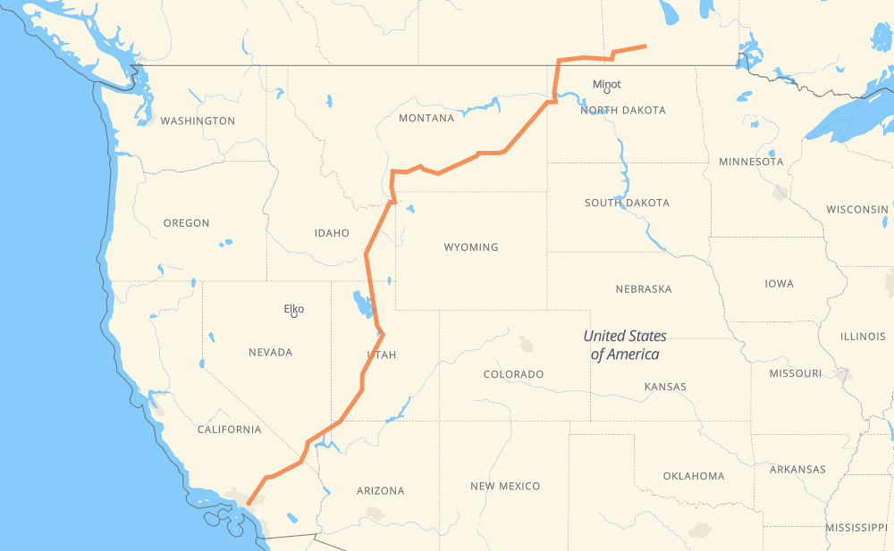
Distance between Anaheim CA and Stockton MB
The distance from Anaheim to Stockton is 2,965 kilometers by road including 2,059 kilometers on motorways. Road takes approximately 30 hours and 14 minutes and goes through Placentia, Fullerton, Brea, Chino Hills, Pomona, Chino and Ontario.
| Shortest distance by air | 2,315 km ✈️ |
| Car route length | 2,965 km 🚗 |
| Driving time | 30 h 14 min |
| Fuel amount | 237.2 L |
| Fuel cost | 467.3 CAD |
| Point | Distance | Time | Fuel | |
| Anaheim | 0 km | 00 min | 0.0 L | |
|
5 km, 04 min
|
||||
| Placentia | 5 km | 04 min | 0.3 L | |
|
CA 57 3 km, 01 min
|
||||
| Fullerton | 9 km | 06 min | 0.5 L | |
|
CA 57 5 km, 02 min
|
||||
| Brea | 14 km | 09 min | 0.9 L | |
|
CA 57 17 km, 10 min
|
||||
| Pomona | 31 km | 20 min | 2.2 L | |
|
CA 60 6 km, 04 min
|
||||
| Chino | 37 km | 24 min | 2.7 L | |
|
CA 60 12 km, 08 min
|
||||
| Ontario | 49 km | 32 min | 3.2 L | |
|
CA 60 16 km, 09 min
|
||||
| Rancho Cucamonga | 65 km | 42 min | 4.5 L | |
|
I 15 8 km, 04 min
|
||||
| Fontana | 73 km | 47 min | 5.8 L | |
|
I 15 44 km, 24 min
|
||||
| Victorville | 117 km | 1 h 11 min | 8.3 L | |
|
I 15 303 km, 2 h 45 min
|
||||
| Las Vegas | 420 km | 3 h 57 min | 33.2 L | |
|
I 15 15 km, 08 min
|
||||
| North Las Vegas | 435 km | 4 h 05 min | 33.9 L | |
|
I 15 173 km, 1 h 37 min
|
||||
| St. George | 608 km | 5 h 43 min | 47.9 L | |
|
I 15 416 km, 3 h 46 min
|
||||
| Provo | 1,023 km | 9 h 29 min | 81.2 L | |
|
I 15 74 km, 40 min
|
||||
| Salt Lake City | 1,097 km | 10 h 10 min | 87.3 L | |
|
I 15 53 km, 29 min
|
||||
| Ogden | 1,151 km | 10 h 39 min | 91.8 L | |
|
I 15 208 km, 2 h 00 min
|
||||
| Pocatello | 1,359 km | 12 h 40 min | 107.7 L | |
|
I 15 77 km, 49 min
|
||||
| Idaho Falls | 1,436 km | 13 h 29 min | 114.4 L | |
|
US 20 315 km, 3 h 37 min
|
||||
| Bozeman | 1,751 km | 17 h 07 min | 139.9 L | |
|
US 191 I 90 225 km, 2 h 09 min
|
||||
| Billings | 1,976 km | 19 h 16 min | 157.4 L | |
|
I 90 I 94 526 km, 5 h 40 min
|
||||
| Williston | 2,502 km | 24 h 57 min | 199.5 L | |
|
US 2 US 85 149 km, 1 h 40 min
|
||||
| Estevan | 2,650 km | 26 h 37 min | 211.0 L | |
|
18 314 km, 3 h 36 min
|
||||
| Stockton | 2,965 km | 30 h 14 min | 236.6 L | |
Frequently Asked Questions
How much does it cost to drive from Anaheim to Stockton?
Fuel cost: 467.3 CAD
This fuel cost is calculated as: (Route length 2,965 km / 100 km) * (Fuel consumption 8 L/100 km) * (Fuel price 1.97 CAD / L)
You can adjust fuel consumption and fuel price here.
How long is a car ride from Anaheim to Stockton?
Driving time: 30 h 14 min
This time is calculated for driving at the maximum permitted speed, taking into account traffic rules restrictions.
- 1,311 km with a maximum speed 110 km/h = 11 h 55 min
- 97 km with a maximum speed 105 km/h = 55 min
- 465 km with a maximum speed 100 km/h = 4 h 39 min
- 6 km with a maximum speed 97 km/h = 3 min
- 672 km with a maximum speed 90 km/h = 7 h 27 min
- 71 km with a maximum speed 89 km/h = 48 min
- 319 km with a maximum speed 80 km/h = 3 h 59 min
- 7 km with a maximum speed 72 km/h = 6 min
- 2 km with a maximum speed 64 km/h = 1 min
- 9 km with a maximum speed 50 km/h = 10 min
- 2 km with a maximum speed 40 km/h = 2 min
- 2 km with a maximum speed 40 km/h = 2 min
The calculated driving time does not take into account intermediate stops and traffic jams.
How far is Anaheim to Stockton by land?
The distance between Anaheim and Stockton is 2,965 km by road including 2,059 km on motorways.
Precise satellite coordinates of highways were used for this calculation. The start and finish points are the centers of Anaheim and Stockton respectively.
How far is Anaheim to Stockton by plane?
The shortest distance (air line, as the crow flies) between Anaheim and Stockton is 2,315 km.
This distance is calculated using the Haversine formula as a great-circle distance between two points on the surface of a sphere. The start and finish points are the centers of Anaheim and Stockton respectively. Actual distance between airports may be different.
How many hours is Anaheim from Stockton by plane?
Boeing 737 airliner needs 2 h 53 min to cover the distance of 2,315 km at a cruising speed of 800 km/h.
Small plane "Cessna 172" needs 10 h 31 min to flight this distance at average speed of 220 km/h.
This time is approximate and do not take into account takeoff and landing times, airport location and other real world factors.
How long is a helicopter ride from Anaheim to Stockton?
Fast helicopter "Eurocopter AS350" or "Hughes OH-6 Cayuse" need 9 h 38 min to cover the distance of 2,315 km at a cruising speed of 240 km/h.
Popular "Robinson R44" needs 11 h 1 min to flight this distance at average speed of 210 km/h.
This time is approximate and do not take into account takeoff and landing times, aerodrome location and other real world factors.
What city is halfway between Anaheim and Stockton?
The halfway point between Anaheim and Stockton is Rexburg. It is located about 3 km from the exact midpoint by road.
The distance from Rexburg to Anaheim is 1,479 km and driving will take about 13 h 58 min. The road between Rexburg and Stockton has length 1,485 km and will take approximately 16 h 16 min.
The other cities located close to halfway point:
Where is Anaheim in relation to Stockton?
Anaheim is located 2,315 km south-west of Stockton.
Anaheim has geographic coordinates: latitude 33.83475, longitude -117.91173.
Stockton has geographic coordinates: latitude 49.58333, longitude -99.45.
Which highway goes from Anaheim to Stockton?
The route from Anaheim to Stockton follows I 15, I 94, I 90, US 191, US 20, 18, US 85.
Other minor sections pass along the road:
- MT 16: 83 km
- US 12: 76 km
- I 84: 62 km
- US 91: 49 km
- PTH 2: 38 km
- US 26: 37 km
- PTH 23: 36 km
- PTH 3: 35 km
- US 212: 35 km
- US 89: 33 km
- US 93: 33 km
- PR 345: 33 km
- US 30: 30 km
- ND 200: 30 km
- PTH 83: 29 km
- US 2: 28 km
- CA 60: 25 km
- CA 57: 19 km
- US 6: 19 km
- MT 200: 19 km
- PTH 10: 17 km
- 350: 16 km
- US 50: 15 km
- MT 84: 11 km
- ND 42: 10 km
- ND 5: 10 km
- UT 30: 8 km
- US 191 US 287: 7 km
- US 287: 6 km
- 39: 6 km
- US 87: 5 km
- ND 1804: 5 km
- PTH 21: 5 km
- MT 200: 4 km
- I 80: 4 km
- CA 18: 4 km
- 39A: 3 km
- I 90 Business: 2 km
- 9: 2 km