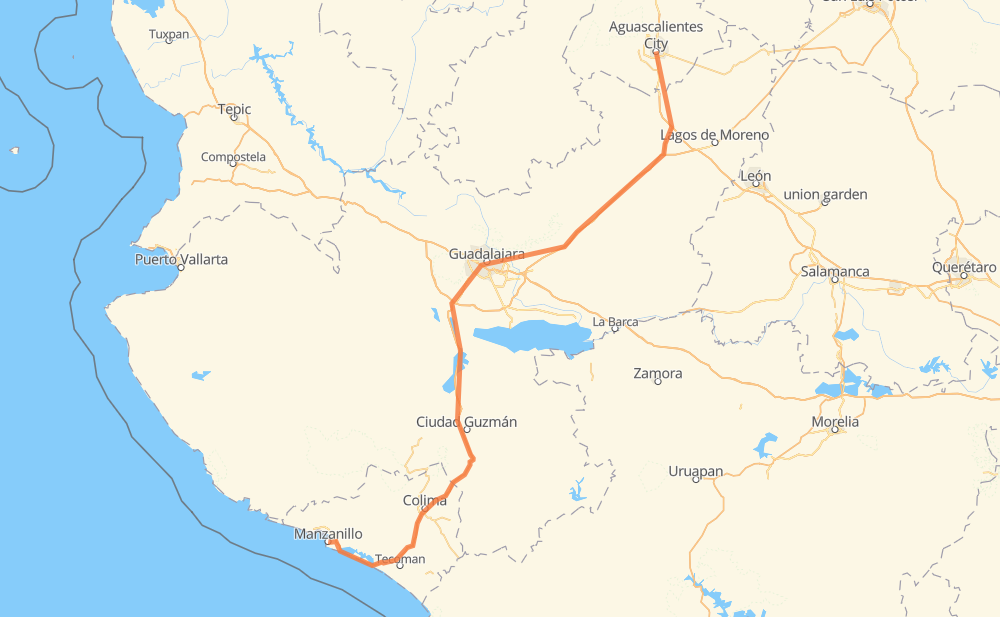
Distance between Aguascalientes and Manzanillo
The distance from Aguascalientes to Manzanillo is 505 kilometers by road including 427 kilometers on motorways. Road takes approximately 5 hours and 23 minutes and goes through Tonalá, Colima, Encarnación de Díaz, Valle de Guadalupe, Pegueros, Lomas de Santa Anita and Cuauhtémoc.
| Shortest distance by air | 379 km ✈️ |
| Car route length | 505 km 🚗 |
| Driving time | 5 h 23 min |
| Fuel amount | 40.4 L |
| Fuel cost | 79.7 CAD |
| Toll roads cost | 541 + ? MXN |
| Point | Distance | Time | Fuel | |
| Aguascalientes | 0 km | 00 min | 0.0 L | |
|
MEX 45 MEX 70 43 km, 27 min
|
||||
| Encarnación de Díaz | 43 km | 27 min | 3.2 L | |
|
MEX 45D MEX 80D 76 km, 44 min
|
||||
| Valle de Guadalupe | 119 km | 1 h 11 min | 9.2 L | |
|
MEX 80D 11 km, 05 min
|
||||
| Pegueros | 129 km | 1 h 17 min | 9.8 L | |
|
MEX 80D 74 km, 44 min
|
||||
| Tonalá | 203 km | 2 h 01 min | 15.6 L | |
|
MEX 15D MEX 80 40 km, 29 min
|
||||
| Lomas de Santa Anita | 243 km | 2 h 31 min | 19.0 L | |
|
MEX 15 MEX 54D 149 km, 1 h 32 min
|
||||
| Cuauhtémoc | 392 km | 4 h 04 min | 30.7 L | |
|
MEX 54D 17 km, 11 min
|
||||
| Colima | 410 km | 4 h 15 min | 32.6 L | |
|
MEX 54D MEX 110D 52 km, 35 min
|
||||
| Ciudad de Armería | 462 km | 4 h 50 min | 36.5 L | |
|
MEX 200D 44 km, 32 min
|
||||
| Manzanillo | 505 km | 5 h 23 min | 40.2 L | |
Hotels of Manzanillo
Frequently Asked Questions
How many toll booths are there from Aguascalientes to Manzanillo?
There are 6 toll booths between Aguascalientes and Manzanillo: Encarnacion De Diaz, Jalostotitlan, Tepatitlan, Sayula, La Joya and Cuyutlan.
How much does the toll booths cost from Aguascalientes to Manzanillo?
Toll roads cost: Encarnacion De Diaz (150 MXN) + Jalostotitlan (177 MXN) + Tepatitlan (214 MXN) + La Joya (?) + Sayula (?) + Cuyutlan (?) = 541 + ? MXN
How much does it cost to drive from Aguascalientes to Manzanillo?
Fuel cost: 79.7 CAD
This fuel cost is calculated as: (Route length 505 km / 100 km) * (Fuel consumption 8 L/100 km) * (Fuel price 1.97 CAD / L)
You can adjust fuel consumption and fuel price here.
Toll roads cost: 541 + ? MXN
How long is a car ride from Aguascalientes to Manzanillo?
Driving time: 5 h 23 min
This time is calculated for driving at the maximum permitted speed, taking into account traffic rules restrictions.
- 119 km with a maximum speed 110 km/h = 1 h 4 min
- 197 km with a maximum speed 100 km/h = 1 h 58 min
- 60 km with a maximum speed 90 km/h = 39 min
- 116 km with a maximum speed 80 km/h = 1 h 26 min
- 8 km with a maximum speed 70 km/h = 6 min
- 2 km with a maximum speed 60 km/h = 1 min
- 5 km with a maximum speed 50 km/h = 5 min
The calculated driving time does not take into account intermediate stops and traffic jams.
How far is Aguascalientes to Manzanillo by land?
The distance between Aguascalientes and Manzanillo is 505 km by road including 427 km on motorways.
Precise satellite coordinates of highways were used for this calculation. The start and finish points are the centers of Aguascalientes and Manzanillo respectively.
How far is Aguascalientes to Manzanillo by plane?
The shortest distance (air line, as the crow flies) between Aguascalientes and Manzanillo is 379 km.
This distance is calculated using the Haversine formula as a great-circle distance between two points on the surface of a sphere. The start and finish points are the centers of Aguascalientes and Manzanillo respectively. Actual distance between airports may be different.
How many hours is Aguascalientes from Manzanillo by plane?
Boeing 737 airliner needs 28 min to cover the distance of 379 km at a cruising speed of 800 km/h.
Small plane "Cessna 172" needs 1 h 43 min to flight this distance at average speed of 220 km/h.
This time is approximate and do not take into account takeoff and landing times, airport location and other real world factors.
How long is a helicopter ride from Aguascalientes to Manzanillo?
Fast helicopter "Eurocopter AS350" or "Hughes OH-6 Cayuse" need 1 h 34 min to cover the distance of 379 km at a cruising speed of 240 km/h.
Popular "Robinson R44" needs 1 h 48 min to flight this distance at average speed of 210 km/h.
This time is approximate and do not take into account takeoff and landing times, aerodrome location and other real world factors.
What city is halfway between Aguascalientes and Manzanillo?
The halfway point between Aguascalientes and Manzanillo is Buenavista. It is located about 1 km from the exact midpoint by road.
The distance from Buenavista to Aguascalientes is 251 km and driving will take about 2 h 37 min. The road between Buenavista and Manzanillo has length 254 km and will take approximately 2 h 45 min.
The other cities located close to halfway point:
Where is Aguascalientes in relation to Manzanillo?
Aguascalientes is located 379 km north-east of Manzanillo.
Aguascalientes has geographic coordinates: latitude 21.88066, longitude -102.29613.
Manzanillo has geographic coordinates: latitude 19.05063, longitude -104.316.
Which highway goes from Aguascalientes to Manzanillo?
The route from Aguascalientes to Manzanillo follows MEX 54D, MEX 80D.
Other minor sections pass along the road:
- MEX 70: 75 km
- MEX 200D: 47 km
- MEX 110D: 40 km
- MEX 80: 36 km
- MEX 45: 28 km
- MEX 15D: 26 km
- MEX 15: 26 km
- MEX 45D: 22 km
- MEX 90: 9 km
- MEX 200: 5 km
- MEX 23: 5 km
- MEX 90D: 3 km