Distance between Agualeguas and Ojo Caliente
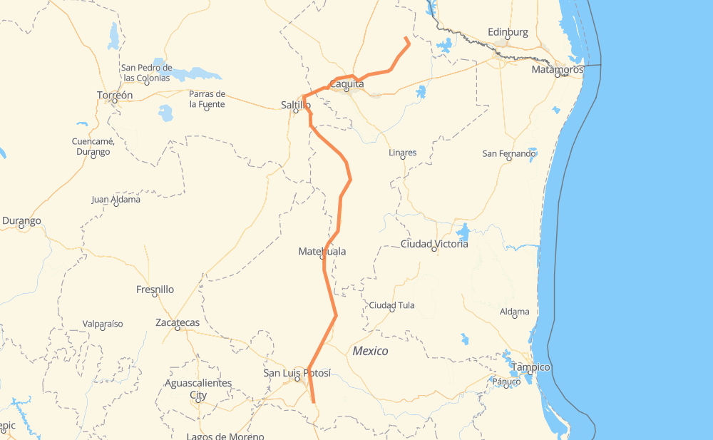
The distance from Agualeguas to Ojo Caliente is 667 kilometers by road including 563 kilometers on motorways. Road takes approximately 7 hours and 2 minutes and goes through General Treviño, Cerralvo, Doctor Gonzalez, Marín, Apodaca, General Escobedo and Rinconada.
| Shortest distance by air | 512 km ✈️ |
| Car route length | 667 km 🚗 |
| Driving time | 7 h 2 min |
| Fuel amount | 53.4 L |
| Fuel cost | 104.6 CAD |
| Toll roads cost | 549 + ? MXN |
| Point | Distance | Time | Fuel | |
| Agualeguas | 0 km | 00 min | 0.0 L | |
|
16 km, 13 min
|
||||
| General Treviño | 16 km | 13 min | 0.2 L | |
|
MEX 54 19 km, 14 min
|
||||
| Cerralvo | 35 km | 28 min | 2.4 L | |
|
MEX 54 43 km, 30 min
|
||||
| Doctor Gonzalez | 78 km | 58 min | 6.0 L | |
|
MEX 54 8 km, 05 min
|
||||
| Marín | 86 km | 1 h 03 min | 6.5 L | |
|
MEX 54 20 km, 13 min
|
||||
| Apodaca | 106 km | 1 h 17 min | 8.2 L | |
|
1610 NL 100D 18 km, 10 min
|
||||
| General Escobedo | 124 km | 1 h 27 min | 9.7 L | |
|
NL 100D 1610 43 km, 25 min
|
||||
| Rinconada | 167 km | 1 h 53 min | 13.2 L | |
|
MEX 40D 38 km, 22 min
|
||||
| Arteaga | 205 km | 2 h 15 min | 16.1 L | |
|
MEX 57D MEX 57 462 km, 4 h 47 min
|
||||
| Huizache | 667 km | 7 h 02 min | 53.3 L | |
Frequently Asked Questions
How many toll booths are there from Agualeguas to Ojo Caliente?
There are 7 toll booths between Agualeguas and Ojo Caliente: La Carbonera, Periférico, Lincoln, Apodaca, Los Chorros, Matehuala Omega and Libramiento Oriente De SLP.
How much does the toll booths cost from Agualeguas to Ojo Caliente?
Toll roads cost: Apodaca (131 MXN) + Lincoln (168 MXN) + Periférico (72 MXN) + La Carbonera (42 MXN) + Los Chorros (66 MXN) + Matehuala Omega (?) + Libramiento Oriente De SLP (70 MXN) = 549 + ? MXN
How much does it cost to drive from Agualeguas to Ojo Caliente?
Fuel cost: 104.6 CAD
This fuel cost is calculated as: (Route length 667 km / 100 km) * (Fuel consumption 8 L/100 km) * (Fuel price 1.96 CAD / L)
You can adjust fuel consumption and fuel price here.
Toll roads cost: 549 + ? MXN
How long is a car ride from Agualeguas to Ojo Caliente?
Driving time: 7 h 2 min
This time is calculated for driving at the maximum permitted speed, taking into account traffic rules restrictions.
- 131 km with a maximum speed 110 km/h = 1 h 11 min
- 230 km with a maximum speed 100 km/h = 2 h 18 min
- 219 km with a maximum speed 90 km/h = 2 h 25 min
- 81 km with a maximum speed 80 km/h = 1 h
- 5 km with a maximum speed 50 km/h = 6 min
The calculated driving time does not take into account intermediate stops and traffic jams.
How far is Agualeguas to Ojo Caliente by land?
The distance between Agualeguas and Ojo Caliente is 667 km by road including 563 km on motorways.
Precise satellite coordinates of highways were used for this calculation. The start and finish points are the centers of Agualeguas and Ojo Caliente respectively.
How far is Agualeguas to Ojo Caliente by plane?
The shortest distance (air line, as the crow flies) between Agualeguas and Ojo Caliente is 512 km.
This distance is calculated using the Haversine formula as a great-circle distance between two points on the surface of a sphere. The start and finish points are the centers of Agualeguas and Ojo Caliente respectively. Actual distance between airports may be different.
How many hours is Agualeguas from Ojo Caliente by plane?
Boeing 737 airliner needs 38 min to cover the distance of 512 km at a cruising speed of 800 km/h.
Small plane "Cessna 172" needs 2 h 19 min to flight this distance at average speed of 220 km/h.
This time is approximate and do not take into account takeoff and landing times, airport location and other real world factors.
How long is a helicopter ride from Agualeguas to Ojo Caliente?
Fast helicopter "Eurocopter AS350" or "Hughes OH-6 Cayuse" need 2 h 8 min to cover the distance of 512 km at a cruising speed of 240 km/h.
Popular "Robinson R44" needs 2 h 26 min to flight this distance at average speed of 210 km/h.
This time is approximate and do not take into account takeoff and landing times, aerodrome location and other real world factors.
What city is halfway between Agualeguas and Ojo Caliente?
The halfway point between Agualeguas and Ojo Caliente is Refugio de los Ibarra. It is located about 14 km from the exact midpoint by road.
The distance from Refugio de los Ibarra to Agualeguas is 347 km and driving will take about 3 h 40 min. The road between Refugio de los Ibarra and Ojo Caliente has length 320 km and will take approximately 3 h 22 min.
The other cities located close to halfway point:
Where is Agualeguas in relation to Ojo Caliente?
Agualeguas is located 512 km north-east of Ojo Caliente.
Agualeguas has geographic coordinates: latitude 26.31262, longitude -99.53748.
Ojo Caliente has geographic coordinates: latitude 21.84712, longitude -100.7541.
Which highway goes from Agualeguas to Ojo Caliente?
The route from Agualeguas to Ojo Caliente follows MEX 57, MEX 57D.
Other minor sections pass along the road:
- MEX 54: 85 km
- MEX 80: 82 km
- 1610: 49 km
- NL 100D: 34 km
- MEX 40D: 28 km
- NL 100: 15 km
- MEX 40: 6 km