Distance between Añatuya and Goya
The distance from Añatuya to Goya is 766 kilometers by road. Road takes approximately 9 hours and 16 minutes and goes through Presidencia Roque Sáenz Peña, Resistencia, Corrientes, Quimilí, General Pinedo, Las Breñas and Corzuela.
| Shortest distance by air | 356 km ✈️ |
| Car route length | 766 km 🚗 |
| Driving time | 9 h 16 min |
| Fuel amount | 61.2 L |
| Fuel cost | 121.3 CAD |
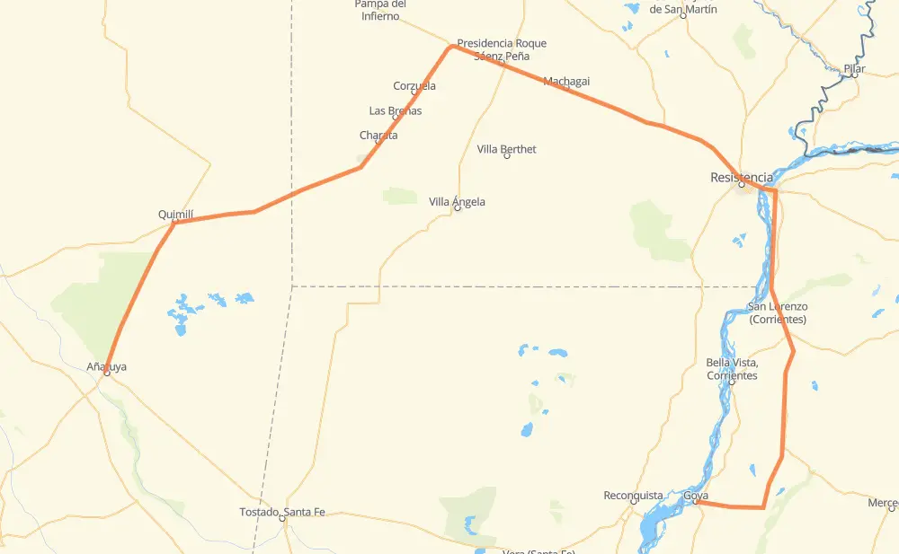
| Point | Distance | Time | Fuel | |
| Añatuya | 0 km | 00 min | 0.0 L | |
|
111 km, 1 h 23 min
|
||||
| Quimilí | 111 km | 1 h 23 min | 0.1 L | |
|
RN89 122 km, 1 h 31 min
|
||||
| General Pinedo | 233 km | 2 h 54 min | 17.6 L | |
|
RN89 47 km, 35 min
|
||||
| Las Breñas | 280 km | 3 h 29 min | 20.2 L | |
|
RN89 RN16 67 km, 51 min
|
||||
| Presidencia Roque Sáenz Peña | 348 km | 4 h 20 min | 25.0 L | |
|
RN16 36 km, 26 min
|
||||
| Machagai | 383 km | 4 h 47 min | 30.6 L | |
|
RN16 31 km, 21 min
|
||||
| Presidencia de la Plaza | 414 km | 5 h 09 min | 30.7 L | |
|
RN16 87 km, 1 h 00 min
|
||||
| Resistencia | 501 km | 6 h 09 min | 39.0 L | |
|
RN16 21 km, 16 min
|
||||
| Corrientes | 522 km | 6 h 26 min | 41.6 L | |
|
RP5 RN12 244 km, 2 h 50 min
|
||||
| Goya | 766 km | 9 h 16 min | 60.6 L | |
Hotels of Goya
Frequently Asked Questions
How much does it cost to drive from Añatuya to Goya?
Fuel cost: 121.3 CAD
This fuel cost is calculated as: (Route length 766 km / 100 km) * (Fuel consumption 8 L/100 km) * (Fuel price 1.98 CAD / L)
You can adjust fuel consumption and fuel price here.
How long is a car ride from Añatuya to Goya?
Driving time: 9 h 16 min
This time is calculated for driving at the maximum permitted speed, taking into account traffic rules restrictions.
- 293 km with a maximum speed 90 km/h = 3 h 15 min
- 449 km with a maximum speed 80 km/h = 5 h 37 min
- 19 km with a maximum speed 60 km/h = 18 min
- 3 km with a maximum speed 50 km/h = 3 min
The calculated driving time does not take into account intermediate stops and traffic jams.
How far is Añatuya to Goya by land?
The distance between Añatuya and Goya is 766 km by road.
Precise satellite coordinates of highways were used for this calculation. The start and finish points are the centers of Añatuya and Goya respectively.
How far is Añatuya to Goya by plane?
The shortest distance (air line, as the crow flies) between Añatuya and Goya is 356 km.
This distance is calculated using the Haversine formula as a great-circle distance between two points on the surface of a sphere. The start and finish points are the centers of Añatuya and Goya respectively. Actual distance between airports may be different.
How many hours is Añatuya from Goya by plane?
Boeing 737 airliner needs 26 min to cover the distance of 356 km at a cruising speed of 800 km/h.
Small plane "Cessna 172" needs 1 h 37 min to flight this distance at average speed of 220 km/h.
This time is approximate and do not take into account takeoff and landing times, airport location and other real world factors.
How long is a helicopter ride from Añatuya to Goya?
Fast helicopter "Eurocopter AS350" or "Hughes OH-6 Cayuse" need 1 h 29 min to cover the distance of 356 km at a cruising speed of 240 km/h.
Popular "Robinson R44" needs 1 h 41 min to flight this distance at average speed of 210 km/h.
This time is approximate and do not take into account takeoff and landing times, aerodrome location and other real world factors.
What city is halfway between Añatuya and Goya?
Where is Añatuya in relation to Goya?
Añatuya is located 356 km west of Goya.
Añatuya has geographic coordinates: latitude -28.45937, longitude -62.83595.
Goya has geographic coordinates: latitude -29.14423, longitude -59.26521.
Which highway goes from Añatuya to Goya?
The route from Añatuya to Goya follows RN12, RN16, RN89.
Other minor sections pass along the road:
- RP92: 98 km