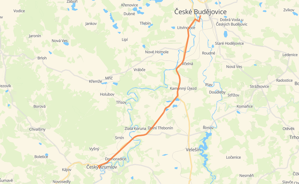
Distance between České Budějovice and Böhmisch Krumau
The distance from České Budějovice to Böhmisch Krumau is 25 kilometers by road. Road takes approximately 20 minutes and goes through Latrán, Litvínovice, Plan, Včelná, Boršov nad Vltavou, Kamenný Újezd and Kosov.
| Shortest distance by air | 22 km ✈️ |
| Car route length | 25 km 🚗 |
| Driving time | 20 min |
| Fuel amount | 2 L |
| Fuel cost | 3.9 CAD |
| Point | Distance | Time | Fuel | |
| České Budějovice | 0 km | 00 min | 0.0 L | |
|
3 3 km, 03 min
|
||||
| Litvínovice | 3 km | 03 min | 0.2 L | |
|
3 2 km, 01 min
|
||||
| Plan | 5 km | 05 min | 0.3 L | |
|
3 2 km, 01 min
|
||||
| Včelná | 7 km | 06 min | 0.5 L | |
|
3 1 km, 00 min
|
||||
| Boršov nad Vltavou | 8 km | 07 min | 0.6 L | |
|
3 2 km, 01 min
|
||||
| Kamenný Újezd | 10 km | 08 min | 0.6 L | |
|
3 39 4 km, 02 min
|
||||
| Kosov | 13 km | 10 min | 0.9 L | |
|
39 5 km, 03 min
|
||||
| Goldenkron | 18 km | 14 min | 1.4 L | |
|
39 2 km, 01 min
|
||||
| Přísečná | 21 km | 15 min | 1.6 L | |
|
39 4 km, 04 min
|
||||
| Böhmisch Krumau | 25 km | 20 min | 1.7 L | |
Hotels of Böhmisch Krumau
Frequently Asked Questions
How much does it cost to drive from České Budějovice to Böhmisch Krumau?
Fuel cost: 3.9 CAD
This fuel cost is calculated as: (Route length 25 km / 100 km) * (Fuel consumption 8 L/100 km) * (Fuel price 1.96 CAD / L)
You can adjust fuel consumption and fuel price here.
How long is a car ride from České Budějovice to Böhmisch Krumau?
Driving time: 20 min
This time is calculated for driving at the maximum permitted speed, taking into account traffic rules restrictions.
- 16 km with a maximum speed 90 km/h = 10 min
- 2 km with a maximum speed 70 km/h = 1 min
- 6 km with a maximum speed 50 km/h = 6 min
The calculated driving time does not take into account intermediate stops and traffic jams.
How far is České Budějovice to Böhmisch Krumau by land?
The distance between České Budějovice and Böhmisch Krumau is 25 km by road.
Precise satellite coordinates of highways were used for this calculation. The start and finish points are the centers of České Budějovice and Böhmisch Krumau respectively.
What city is halfway between České Budějovice and Böhmisch Krumau?
The halfway point between České Budějovice and Böhmisch Krumau is Kosov. It is located about 1 km from the exact midpoint by road.
The distance from Kosov to České Budějovice is 13 km and driving will take about 10 min. The road between Kosov and Böhmisch Krumau has length 11 km and will take approximately 9 min.
The other cities located close to halfway point:
Where is České Budějovice in relation to Böhmisch Krumau?
České Budějovice is located 22 km north-east of Böhmisch Krumau.
České Budějovice has geographic coordinates: latitude 48.97474, longitude 14.47429.
Böhmisch Krumau has geographic coordinates: latitude 48.81117, longitude 14.31515.
Which highway goes from České Budějovice to Böhmisch Krumau?
The route from České Budějovice to Böhmisch Krumau follows 39, 3.