Distance between Sudbury ON and Penticton BC
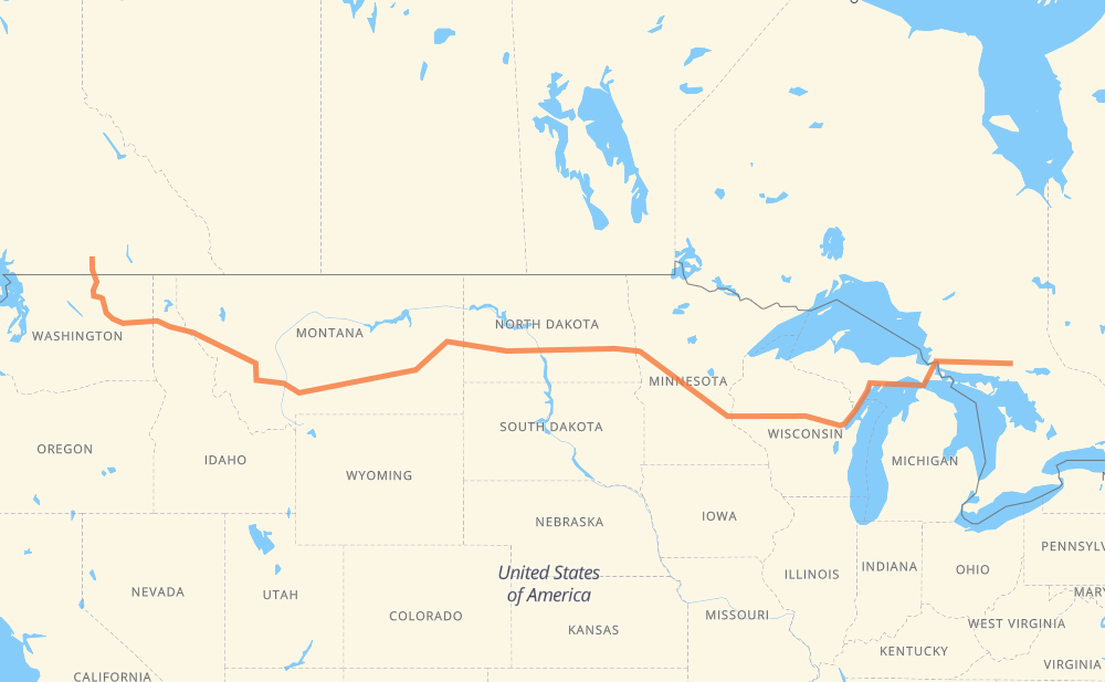
The distance from Sudbury to Penticton is 3,788 kilometers by road including 2,603 kilometers on motorways. Road takes approximately 59 hours and 30 minutes and goes through Sault Ste. Marie, Escanaba, Fargo, West Fargo, Bismarck, Mandan and Dickinson.
| Shortest distance by air | 2,861 km ✈️ |
| Car route length | 3,788 km 🚗 |
| Driving time | 59 h 30 min |
| Fuel amount | 1,113.6 L |
| Fuel cost | 8,006.8 CAD |
| Point | Distance | Time | Fuel | |
| Sudbury | 0 km | 00 min | 0.0 L | |
|
55 17 306 km, 5 h 24 min
|
||||
| Sault Ste. Marie | 306 km | 5 h 24 min | 88.1 L | |
|
17 US 2 313 km, 5 h 19 min
|
||||
| Escanaba | 618 km | 10 h 44 min | 181.1 L | |
|
M 35 I 94 967 km, 15 h 12 min
|
||||
| Fargo | 1,586 km | 25 h 57 min | 465.5 L | |
|
I 94 7 km, 06 min
|
||||
| West Fargo | 1,593 km | 26 h 03 min | 466.9 L | |
|
I 94 296 km, 4 h 21 min
|
||||
| Bismarck | 1,889 km | 30 h 24 min | 552.5 L | |
|
I 94 29 km, 25 min
|
||||
| Mandan | 1,918 km | 30 h 50 min | 558.3 L | |
|
I 94 127 km, 1 h 52 min
|
||||
| Dickinson | 2,045 km | 32 h 42 min | 598.6 L | |
|
I 94 518 km, 7 h 36 min
|
||||
| Billings | 2,563 km | 40 h 19 min | 751.0 L | |
|
I 90 363 km, 5 h 20 min
|
||||
| Butte | 2,926 km | 45 h 39 min | 853.2 L | |
|
I 90 185 km, 2 h 42 min
|
||||
| Missoula | 3,111 km | 48 h 22 min | 913.7 L | |
|
I 90 265 km, 3 h 54 min
|
||||
| Coeur d'Alene | 3,376 km | 52 h 16 min | 990.8 L | |
|
I 90 54 km, 47 min
|
||||
| Spokane | 3,430 km | 53 h 04 min | 1,006.0 L | |
|
US 2 226 km, 4 h 02 min
|
||||
| Omak | 3,656 km | 57 h 06 min | 1,072.7 L | |
|
WA 20 US 97 133 km, 2 h 24 min
|
||||
| Penticton | 3,788 km | 59 h 30 min | 1,112.1 L | |
Hotels of Penticton
Frequently Asked Questions
How much does it cost to drive from Sudbury to Penticton?
Fuel cost: 8,006.8 CAD
This fuel cost is calculated as: (Route length 3,788 km / 100 km) * (Fuel consumption 29.40 L/100 km) * (Fuel price 7.19 CAD / L)
You can adjust fuel consumption and fuel price here.
How long is a car ride from Sudbury to Penticton?
Driving time: 59 h 30 min
This time is calculated for driving at the maximum permitted speed, taking into account traffic rules restrictions.
- 2,603 km with a maximum speed 68 km/h = 38 h 16 min
- 1,162 km with a maximum speed 56 km/h = 20 h 44 min
- 12 km with a maximum speed 50 km/h = 14 min
- 8 km with a maximum speed 48 km/h = 10 min
- 3 km with a maximum speed 40 km/h = 3 min
The calculated driving time does not take into account intermediate stops and traffic jams.
How far is Sudbury to Penticton by land?
The distance between Sudbury and Penticton is 3,788 km by road including 2,603 km on motorways.
Precise satellite coordinates of highways were used for this calculation. The start and finish points are the centers of Sudbury and Penticton respectively.
How far is Sudbury to Penticton by plane?
The shortest distance (air line, as the crow flies) between Sudbury and Penticton is 2,861 km.
This distance is calculated using the Haversine formula as a great-circle distance between two points on the surface of a sphere. The start and finish points are the centers of Sudbury and Penticton respectively. Actual distance between airports may be different.
How many hours is Sudbury from Penticton by plane?
Boeing 737 airliner needs 3 h 34 min to cover the distance of 2,861 km at a cruising speed of 800 km/h.
Small plane "Cessna 172" needs 13 h to flight this distance at average speed of 220 km/h.
This time is approximate and do not take into account takeoff and landing times, airport location and other real world factors.
How long is a helicopter ride from Sudbury to Penticton?
Fast helicopter "Eurocopter AS350" or "Hughes OH-6 Cayuse" need 11 h 55 min to cover the distance of 2,861 km at a cruising speed of 240 km/h.
Popular "Robinson R44" needs 13 h 37 min to flight this distance at average speed of 210 km/h.
This time is approximate and do not take into account takeoff and landing times, aerodrome location and other real world factors.
What city is halfway between Sudbury and Penticton?
The halfway point between Sudbury and Penticton is Bismarck. It is located about 5 km from the exact midpoint by road.
The distance from Bismarck to Sudbury is 1,889 km and driving will take about 30 h 23 min. The road between Bismarck and Penticton has length 1,899 km and will take approximately 29 h 7 min.
The other cities located close to halfway point:
Where is Sudbury in relation to Penticton?
Sudbury is located 2,861 km east of Penticton.
Sudbury has geographic coordinates: latitude 46.49272, longitude -80.99121.
Penticton has geographic coordinates: latitude 49.49489, longitude -119.59442.
Which highway goes from Sudbury to Penticton?
The route from Sudbury to Penticton follows I 94, I 90, US 2, WI 29, 17, US 12, US 52.
Other minor sections pass along the road:
- M 35: 98 km
- US 191: 92 km
- US 41: 91 km
- WA 155: 87 km
- I 75: 83 km
- US 97: 73 km
- 97: 63 km
- I 694: 46 km
- WA 20: 38 km
- US 83: 36 km
- US 212: 34 km
- WA 174: 30 km
- WI 55: 23 km
- MT 200: 22 km
- US 59: 17 km
- WI 73: 15 km
- CTH S: 15 km
- 55: 13 km
- I 15: 12 km
- ND 3: 12 km
- US 89: 11 km
- WI 47: 10 km
- ND 1: 8 km
- US 93: 8 km
- MN 95: 7 km
- US 141: 6 km
- WI 160: 5 km
- MN 210: 5 km
- US 51: 5 km
- WI 32: 5 km
- US 10: 5 km
- WA 231: 5 km
- US 87: 4 km
- US 395: 4 km
- WI 35: 4 km
- ND 22 Bypass: 4 km
- CTH E: 3 km
- US 45: 3 km
- US 52 Truck: 3 km
- CTH D: 3 km
- US 281 Truck: 2 km