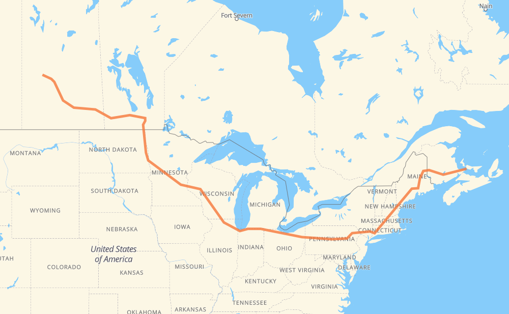
Distance between Borden PE and Ruddell SK
The distance from Borden to Ruddell is 4,862 kilometers by road including 3,786 kilometers on motorways. Road takes approximately 48 hours and 19 minutes and goes through Moncton, Fredericton, Bangor, Waterville, Augusta, Portland and Lowell.
| Shortest distance by air | 3,218 km ✈️ |
| Car route length | 4,862 km 🚗 |
| Driving time | 48 h 19 min |
| Fuel amount | 389 L |
| Fuel cost | 521.2 CAD |
| Point | Distance | Time | Fuel | |
| Borden | 0 km | 00 min | 0.0 L | |
|
Trans Canada Highway 15 110 km, 1 h 10 min
|
||||
| Moncton | 110 km | 1 h 10 min | 8.1 L | |
|
2 170 km, 1 h 32 min
|
||||
| Fredericton | 280 km | 2 h 43 min | 22.0 L | |
|
2 I 95 305 km, 2 h 56 min
|
||||
| Bangor | 585 km | 5 h 39 min | 45.8 L | |
|
I 95 101 km, 55 min
|
||||
| Waterville | 686 km | 6 h 35 min | 53.7 L | |
|
I 95 20 km, 11 min
|
||||
| Augusta | 706 km | 6 h 46 min | 56.1 L | |
|
I 95 I 295 88 km, 49 min
|
||||
| Portland | 794 km | 7 h 36 min | 63.3 L | |
|
I 295 I 95 155 km, 1 h 29 min
|
||||
| Lowell | 949 km | 9 h 05 min | 75.8 L | |
|
I 495 I 84 179 km, 1 h 46 min
|
||||
| Hartford | 1,128 km | 10 h 52 min | 89.9 L | |
|
I 84 43 km, 26 min
|
||||
| Waterbury | 1,171 km | 11 h 19 min | 93.2 L | |
|
I 84 261 km, 2 h 34 min
|
||||
| Scranton | 1,432 km | 13 h 54 min | 114.3 L | |
|
I 81 I 80 615 km, 5 h 41 min
|
||||
| Elyria | 2,048 km | 19 h 35 min | 163.6 L | |
|
I 80 137 km, 1 h 14 min
|
||||
| Toledo | 2,185 km | 20 h 49 min | 174.5 L | |
|
I 80 234 km, 2 h 07 min
|
||||
| South Bend | 2,419 km | 22 h 57 min | 193.0 L | |
|
I 80 I 90 315 km, 3 h 02 min
|
||||
| Janesville | 2,734 km | 26 h 00 min | 218.4 L | |
|
I 39 56 km, 30 min
|
||||
| Madison | 2,790 km | 26 h 31 min | 222.5 L | |
|
I 39 I 94 282 km, 2 h 34 min
|
||||
| Eau Claire | 3,072 km | 29 h 05 min | 244.9 L | |
|
I 94 526 km, 4 h 52 min
|
||||
| Fargo | 3,598 km | 33 h 58 min | 287.1 L | |
|
I 29 102 km, 1 h 10 min
|
||||
| Grand Forks | 3,700 km | 35 h 08 min | 294.0 L | |
|
I 29 243 km, 2 h 47 min
|
||||
| Winnipeg | 3,943 km | 37 h 55 min | 314.5 L | |
|
PTH 100 PTH 1 88 km, 59 min
|
||||
| Portage la Prairie | 4,031 km | 38 h 55 min | 321.9 L | |
|
PTH 1 123 km, 1 h 22 min
|
||||
| Brandon | 4,154 km | 40 h 17 min | 332.0 L | |
|
PTH 1 1 362 km, 4 h 07 min
|
||||
| Regina | 4,515 km | 44 h 24 min | 360.9 L | |
|
46 11 253 km, 2 h 49 min
|
||||
| Saskatoon | 4,769 km | 47 h 14 min | 380.8 L | |
|
11 16 104 km, 1 h 10 min
|
||||
| Ruddell | 4,872 km | 48 h 25 min | 389.8 L | |
Frequently Asked Questions
How much does it cost to drive from Borden to Ruddell?
Fuel cost: 521.2 CAD
This fuel cost is calculated as: (Route length 4,862 km / 100 km) * (Fuel consumption 8.00 L/100 km) * (Fuel price 1.34 CAD / L)
You can adjust fuel consumption and fuel price here.
How long is a car ride from Borden to Ruddell?
Driving time: 48 h 19 min
This time is calculated for driving at the maximum permitted speed, taking into account traffic rules restrictions.
- 2,617 km with a maximum speed 110 km/h = 23 h 47 min
- 537 km with a maximum speed 105 km/h = 5 h 7 min
- 199 km with a maximum speed 100 km/h = 1 h 59 min
- 59 km with a maximum speed 97 km/h = 36 min
- 932 km with a maximum speed 90 km/h = 10 h 21 min
- 99 km with a maximum speed 89 km/h = 1 h 6 min
- 15 km with a maximum speed 80 km/h = 10 min
- 387 km with a maximum speed 80 km/h = 4 h 50 min
- 5 km with a maximum speed 72 km/h = 4 min
- 4 km with a maximum speed 70 km/h = 3 min
- 3 km with a maximum speed 60 km/h = 3 min
- 6 km with a maximum speed 50 km/h = 6 min
The calculated driving time does not take into account intermediate stops and traffic jams.
How far is Borden to Ruddell by land?
The distance between Borden and Ruddell is 4,862 km by road including 3,786 km on motorways.
Precise satellite coordinates of highways were used for this calculation. The start and finish points are the centers of Borden and Ruddell respectively.
How far is Borden to Ruddell by plane?
The shortest distance (air line, as the crow flies) between Borden and Ruddell is 3,218 km.
This distance is calculated using the Haversine formula as a great-circle distance between two points on the surface of a sphere. The start and finish points are the centers of Borden and Ruddell respectively. Actual distance between airports may be different.
How many hours is Borden from Ruddell by plane?
Boeing 737 airliner needs 4 h 1 min to cover the distance of 3,218 km at a cruising speed of 800 km/h.
Small plane "Cessna 172" needs 14 h 37 min to flight this distance at average speed of 220 km/h.
This time is approximate and do not take into account takeoff and landing times, airport location and other real world factors.
How long is a helicopter ride from Borden to Ruddell?
Fast helicopter "Eurocopter AS350" or "Hughes OH-6 Cayuse" need 13 h 24 min to cover the distance of 3,218 km at a cruising speed of 240 km/h.
Popular "Robinson R44" needs 15 h 19 min to flight this distance at average speed of 210 km/h.
This time is approximate and do not take into account takeoff and landing times, aerodrome location and other real world factors.
What city is halfway between Borden and Ruddell?
The halfway point between Borden and Ruddell is South Bend. It is located about 12 km from the exact midpoint by road.
The distance from South Bend to Borden is 2,419 km and driving will take about 22 h 56 min. The road between South Bend and Ruddell has length 2,444 km and will take approximately 25 h 23 min.
The other cities located close to halfway point:
Where is Borden in relation to Ruddell?
Borden is located 3,218 km east of Ruddell.
Borden has geographic coordinates: latitude 46.25336, longitude -63.69644.
Ruddell has geographic coordinates: latitude 52.60327, longitude -107.85234.
Which highway goes from Borden to Ruddell?
The route from Borden to Ruddell follows I 80, I 90, I 94, I 95, I 84, PTH 1, 2, 11, I 29, 1, US 81, I 39, 16, I 495.
Other minor sections pass along the road:
- PTH 75: 94 km
- I 295: 86 km
- 15: 59 km
- I 81: 56 km
- I 694: 46 km
- US 6: 37 km
- US 51: 30 km
- US 220: 26 km
- 46: 22 km
- US 41: 22 km
- PTH 100: 19 km
- US 59: 17 km
- 95: 14 km
- Trans Canada Highway: 13 km
- 7: 11 km
- NY 52: 11 km
- US 12: 9 km
- 11A: 9 km
- 47: 8 km
- PTH 83: 7 km
- MN 95: 7 km
- SR 11: 6 km
- 105: 6 km
- US 1: 6 km
- PA 66: 6 km
- US 7: 6 km
- PA 309: 6 km
- I 380: 5 km
- US 202: 5 km
- PR 254: 5 km
- MN 210: 5 km
- US 220 Alternate: 5 km
- US 10: 5 km
- ME 15: 4 km
- US 52: 4 km
- PR 241: 4 km
- WI 35: 4 km
- PA 28 Truck: 4 km
- PR 250: 4 km
- 6: 3 km
- US 20: 3 km
- WI 11: 3 km
- Route 42: 3 km
- TCH: 3 km
- PR 427: 2 km
- PR 334: 2 km
- 12: 2 km
- PTH 10: 2 km
- 8: 1 km